
New City Landscape – Seoul
Seoul is the capital and largest city of South Korea. A megacity with a population of over 10 million, it is one of the largest cities in the world. Seoul proper is noted for its population density, which is almost twice as concentrated as New York and eight times greater than Rome, though slightly less than that of Paris. The use of technology in everyday live is very integrated, even more so than in western cities that only are discovering the connectedness. In this sense the number of tweets being sent from Seoul is very high, with a high percentage of location based tweets.
The Seoul New City Landscape (NCL) map is generated purely from geolocated tweets, sent over the period of one week using the devices GPS information. This is virtual landscape generated from tweet density sent from within a 30 km radius of the Seoul region. NCL is an ongoing project and we have covered cities worldwide. An overview can be found HERE.
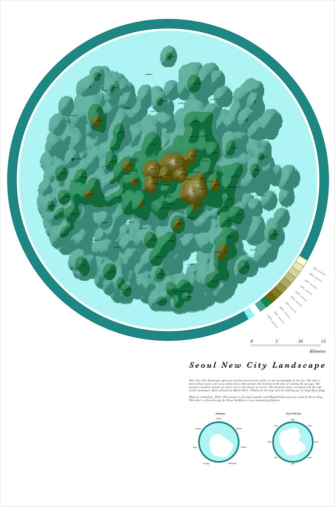
Image by urbanTick for NCL / Seoul New City Landscape map generated from location based tweets collected over the period of one week. The area covered is within a 30 km radius of Seoul.
In terms of the morphology, the Seoul NCL is a type with more than one centre. There are two main centres with additional smaller centres of high activity. Even though it is not visible, the river dividing the two main centres can be imagined from the landscape. The smaller centres dotted around belong to ‘new towns’ built around 1980 with predominately residential usage.
The main area to the West is the ‘old centre’ of Seoul with the formal institutions, the palace and the main tourist destinations. There is also business, mainly baking and shopping. The main area to the East is the ‘new centre’ with a sort of London Soho touch. This includes again shopping and business.
Regarding the airport, wich is usually a very active spot on the NCL maps, in Soul the International airport is outside the covered area, but the old Seoul airport for domestic flights is on there to the West of the centre. However, it is not very active and only shows as a small hill.
Seoul New City Landscape
Image by urbanTick using the GMap Image Cutter / Seoul New City Landscape -Use the Google Maps style zoom function in the top right corner to zoom into the map and explore it in detail. Explore areas you know close up and find new locations you have never heard of. Click HERE for a full screen view. The maps were created using our CASA Tweet-O-Meter, in association with DigitalUrban and coded by Steven Gray, this New City Landscape represents location based twitter activity. Thanks for the help with the labeling to Sung-Hyun Jang from AR+GIS.
The temporal usage of twitter in Seoul is indeed different from the European and American cities. There is on the week day rose a clear preference for mid week activity. The weekend is not very active also Monday is very slow. On the 24 hours scale Seoul shows the typical dip in the early morning hours around 3-4 o’clock, but other than that it does not relate to the kidney shape of western cities. It has some four peaks, one in the morning one over midday, one in the evening and one around midnight. It look as if people in Seoul would tweet more or less four times a day. Overall it is one of the cities more active in the second part of the day with a very late night.
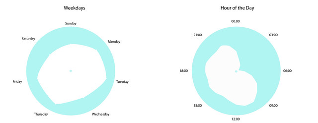
Image by urbanTick for NCL / The lefthand rose shows the twitter activity over the days of the week, starting with Sunday at the top, going clockwise. The rose on the right shows the tweet activity per hour of the day, starting at 00:00 at the top. Here we are showing local time in Seoul. Hence the characteristic dip between three and five o’clock in the morning. Seoul is a typical evening city with more activity n the late hours of the day. For more details on the time comparision with other NCL urban areas please see the presentation post ‘Twitter Data – Seeking Spatial Patter’