
New City Landscape – Calgary
Calgary was established in 1875 as Fort Brisebois by the North-West Mounted Police, located at the confluence of the Bow and Elbow rivers in what is now Calgary, Alberta. Today Calgary is the largest city in Alberta and directs an oil and gas empire, making a rather good situated urban centre.
The city is located similar to Denver at the transition zone between the prairie in the East and the Rocky Mountains in the West. This dominates the views and the impression of the place. However, unlike in Denver the tall mountains are further in the distance. The rockies in Alberta fade out in to the flat land with smaller hills.
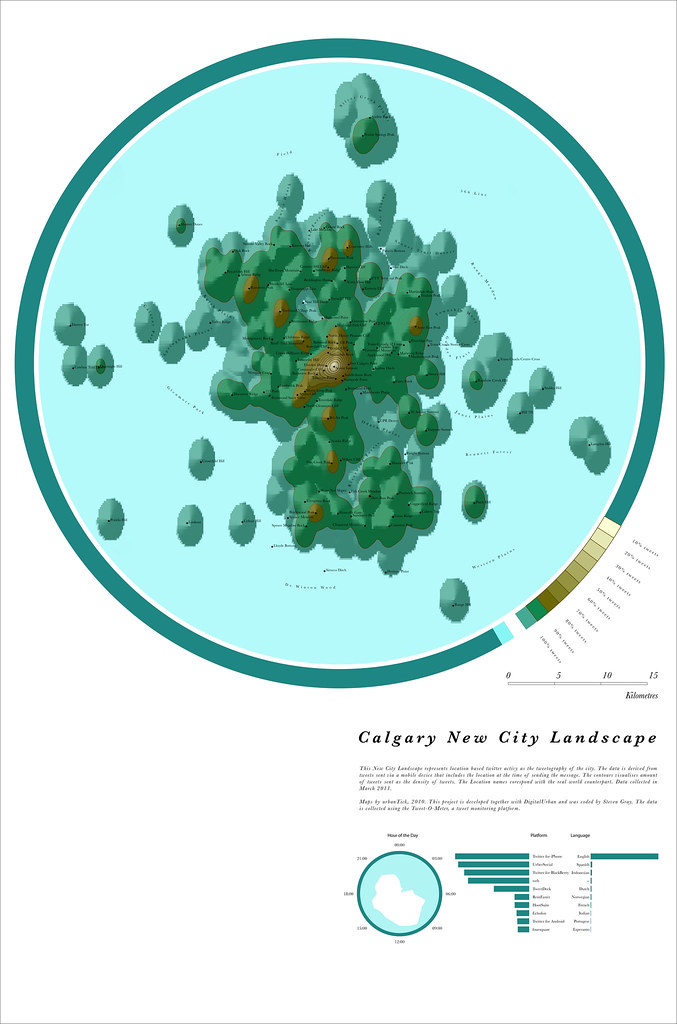
Image by urbanTick for NCL / Calgary New City Landscape map generated from location based tweets collected over the period of one week. The area covered is within a 30 km radius of Calgary.
The urban area is quite active on Twitter and the NCL map draws out the city features nicely. The main features are the airport, the downtown, the absent Nose Hill Park. Also the the main movement corridor the famous Calgary Y shape shows up on the map as a North West to South Centre connection with a North East connection via the airport.
Calgary New City Landscape
Image by urbanTick using the GMap Image Cutter / Calgary New City Landscape Use the Google Maps style zoom function in the top right corner to zoom into the map and explore it in detail. Explore areas you know close up and find new locations you have never heard of. Click HERE for a full screen view. The maps were created using our CASA Tweet-O-Meter, in association with DigitalUrban and coded by Steven Gray, this New City Landscape represents location based twitter activity.
The main peak is over the downtown area as expected. The summit is right above the Scotia Centre building. This central mountain extends to the South West towards the Access Cliff and to the North East to the Highland Park Cliff.
Some of the missing areas are the Nose Hill Park which appears completely empty on the Twitter map with basically no activity. Also around the CPR the tweet desert spreads far, all the way down to the Bennett Forest.

Image taken from Wikimedia / Calgary as it appeared circa 1885.
The Y shaped sequence of hills connecting the downtown area to the outskirts follows the main transport arteries of Calgary, the C-Train.
This transport system is the core of public transport in Calgary and free in the Downtown area but extends beyond. It is accomplished by a bus network.
The City of Calgary is very much a morning city with quite a bit more tweets sent in the morning hours between eight and twelve. The afternoon is slow and the nights early, with the characteristic night dip starting before three and ending soon after four.
The dominating language is clearly English with other languages used on Twitter in this area being very low. For the platforms used the four dominating ones are Twitter for iPhone, Ueber Social, Twitter for Black Berry and the web.
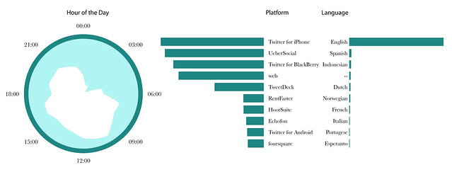
Image by urbanTick for NCL / The rose shows the twitter activity per hour of the day, starting at 00:00 at the top, displayed as local time. Calgary is a morning city with more activity between eight and twelve than through out the afternoon and evening. The graphs show the platform of preference used to send the tweet and the language set respectively.