
7th Virtual Cities and Territories Lisbon
I will be at the 7th Virtual Cities and Territories conference in Lisbon today. The conference ihas six theme tracks Modeling for urban and spatial analysis, Sustainability, Urban Form and Urban Design, New Technologies in Architecture, Urban Design and e-Planning, Housing and Land Policy, Governance, Competitiveness and Innovation, Land management for urban dynamics and is co-hosted by José António Tenedório, e-GEO-FCSH-UNL and Nuno Norte Pinto, DEC-UC.
Conference registration starts on October 11th, at 8:30 am at the lobby of the Reitoria building, where you will receive your conference kit.
The opening session will take place at 9:30 am at the Auditório A (Reitoria building), with the presence of Prof. António Rendas, the Rector of the NOVA University of Lisbon, and of Prof. João Gabriel Silva, the Rector of the University of Coimbra.
At 10:00 am we will have the opening keynote lecture by Prof. Michael Batty.
The conference puts forward an interesting conceptualised summary of the topics as something called “five fingers”.
“Inventory finger”: The papers reflect the need to structure information acquired by modern means such as 3D laser scanning and satellite images.
“Visualization finger”: The visualization, namely the 3D, is currently an effective way to promote public participation in plans. The third dimension and the possibility of its manipulation is a powerful computational representation of the city and of the territory.
“Analysis Finger”: Shape analysis, urban and territorial processes, as well as the manipulation of spectral data, image segmentation, image processing, object-oriented analysis, and networks analysis (transport, social, etc.) are currently the starting points in the debate of the importance of geographic information in the organizations.
“Modeling and simulation finger”: Computer Science has become a key research field for modeling spatial phenomena in Geography, Architecture, Engineering, and Town Planning.
“e-Planning finger”: The conjugation of the previous “fingers” allows the construction of new electronic tools or computational representations of city and territories. Consequently, virtual cities and territories become the new place for planning and for designing the real world.
I will be presenting the paper NCL – Tracking Location Based Social Networks Using Twitter Data discussing how currently static descriptions of urban areas can become dynamic using data available through mobile technologies and digital social networks. The key to this shift lies in the fact that the new data allows analysis completely independent from established location formula and boundaries. The description emerges from the action not the location. The facts are newly laid out and a true dynamic description can only be achieved if fix points are eliminated. The new information is only pinned down on the here and now. With the new media everywhere is here and here is everywhere.
Since the conference is in Lisbon it makes sense to put together a few Twitter images on the place. It is not the most active place but still generates a fair amount of location based tweets over one week.
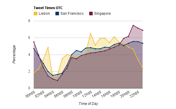
Image by urbanTick for NCL / Tweet times compared between Lisbon, San Francisco and Singapore. Lisbon has this characteristic four o’clock peak at night. It is very strong on the weekend. Another characteristic is the slow start in the morning the work plateau and te jump over lunch to the evening plateau where it drops off quickly.
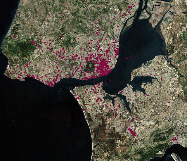
Image by urbanTick for NCL / Tweets by location mainly in the centre and along the river shores.
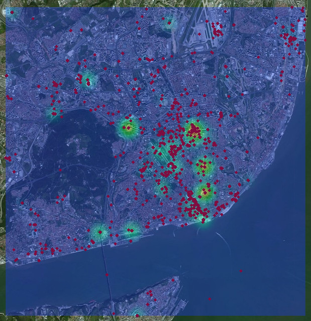
Image by urbanTick for NCL / Tweets around the centre of Lisbon witha few hotspots highlighted by a crude density estimation. For example the Instituto Superior Técnico is a spot as well as the Estádio da Luz in the top left corner.