

The Fastest Connection in the City

Image taken from KurierZentrale / Bicycle messenger in action.
The bicycle couriers are probably the jguys with the best local knowledge there are to be found for any city. From their daily experience of navigating the streets and blocks specific non physical aspects are expected to influence the decision making process. This includes traffic, terrain, season or weather maybe. As part of this project we are planning to look into these influencing aspects.
On the other hand another interest is on how the service the couriers provide describes the city. In many ways the activity of delivering mail between different locations creates a network of connections. This describes the city in terms of links. Beyond the locations of the sender and receiver, the interesting part is in how this connection physically manifests in an optimised routing provided by the courier. As part of the project the aim is to develop these relationships into a descriptive atlas of the city linking the aspects of a social network to the physical conditions of the link.
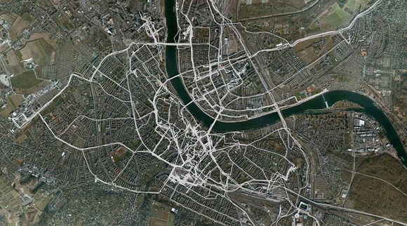
Image by urbanTick for KurierT / Routing around Basel showing the tracks of one courier over two days. Software used Cartogaphica.
The couriers offer a range of services. Whilst most of the jobs are small parcels and letters between different businesses in the city, there are jobs in the wider region of Basel or heavier loads for which the couriers change from bicycle to a car. Beside the business services the couriers have a meal service over lunch and in the evening around dinner time. From a selections of restaurants in the city meals can be ordered and get them delivered.
This combination of business and private services makes the data collected ver rich in that we not only have a picture of the business contacts but also see a shift in activities and cover residential areas. This extended business model covers more areas in the city and the expected black spots in the urban fragment not covered by the couriers’ movements are dramatically reduced. The resulting overview covers a very particular perspective on the city and generalisation is limited, but within the particular setting the results are expected to provide valuable insight in urban connections, urban networks and routing. In terms of planning this has practical application for example in the provision of cycle routes for the general public.
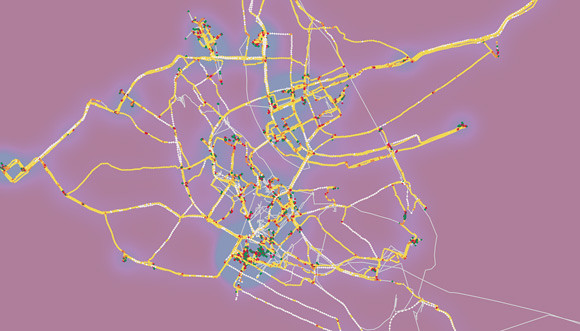
Image by urbanTick for KurierT / Routing around Basel showing the tracks of one courier over two days. The tracks are coloured according to speed. Red is slow and white is fast, above 30. The background shows a point density indicating locations and high traffic areas. Software used Cartogaphica.
The temporal aspect of traveling the city is particularly part of the bicycle messenger daily business. Besides safely getting from A to B the speed of delivery is crucial and directly influences not only the customer satisfaction but the daily salary of the rider. From a research perspective these constraints are interesting as to how accessible the different areas of the city actually are. The data will be analysed towards the time cost of travel from a whole range of origins. Based on speed and and travel time the results can be summarised in a time zone map of the city, indicating accessibility.
Ultimately the results are expected to feed into a description of urban space. This description will be focused towards physical quality and identity of place. In comparison to existing political defined neighbourhoods the results form this study are expected to lead to an alternative description of urban areas based on connection and time.
The project is developed in collaboration with the Institut Vermessung und Geoinformation. For the analysis one of the tools developed at the institute called See You will be used. The online GIS system analyses GPS tracks based on point density and stationary time. The GPS tracks are interpreted as heat map and hotspots are marked by the system based on the analysis of stationary time. These can be filtered based on duration. In the example below for example the no 1 (bottom of the picture) identifies the location of the KurierZentrale offices as the most important location of the map. The riders start from here and return back to after the shift.
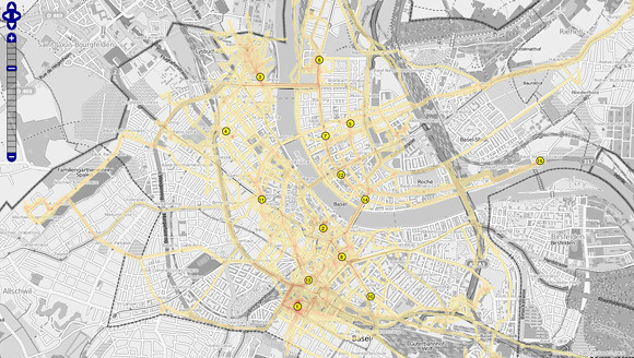
Image by urbanTick for KurierT / Routing around Basel showing the tracks of one courier over two days. The online GIS service SeeYou developed by the Institut Vermessung und Geoinformation at FHNW is used for the visualisation. Tracks shown as a heat map. As background the OSM service is used. The numbers highlight important locations as interpreted by the system automatically.
The project runs over the next couple of month and results will be posted along the way. A report is expected towards the end of the year. Continuous updates will be posted here, so stay tuned. A detailed project desription can be found online at the Institut Architektur.