
Geodesign
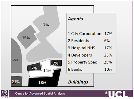
Presenting this morning at ESRI Geodesign Summit with the title Simulating Geodesign: Agents as Designers, Agents as Buildings. Click on the pdf to get a sense of what this is about. Most geodesign is the application of spatial analytics and map analysis within a rational planning process to problems of collective design but my own paper is more about how we should formally explore the actual process of designing. In fact more like the process of decision-making. I propose a model of collective action that leads to consensus under rationality but of course could lead to various kinds of decision or non-decision. Essentially the model is one which enables stakeholders with an interest in the problem which they express in the form of suitability maps for some purpose, to swap and pool their ‘maps’ – opinions and reach a consensus through successive averaging. The neat thing is that the problem is posed as one of averaging elements or locations or sties in each may by different stakeholder agents and this let us examine what happens is the sites are averaged as well as the opinions of the agents. Thus the problem can be regarded as having a primal form where stakeholders average and dual form where sites – locations – are averaged. I show the method using a toy example for change of use amongst 6 stakeholders and 8 sites in the heart of the City of London.
This is a proof of concept. I will work o it in the next few months and bash our a more technical paper and am about to write a short note on it following the geodesign meeting for ArcNews which I will post when it is done. Actually an interesting meeting here in general and I am impressed by the flexibility that ESRI are introducing into their suite of GIS products which now incorporate tools for geodesign.