
Chapter in Routledge Handbook of Environmental Justice – Participatory GIS and community-based citizen science for environmental justice action
The Routledge Handbook of Environmental Justice has been published in mid-September. This extensive book, of 670 pages is providing an extensive overview of scholarly research on environmental justice. 
The book was edited by three experts in the area – Ryan Holifield from the University of Wisconsin-Milwaukee, Jayajit Chakraborty from the University of Texas at El Paso, and Gordon Walker from the Lancaster Environment Centre, Lancaster University, UK. All three have affiliations that relate to Geography, and geographic and environmental information play a major part in the analysis and action regarding environmental justice.
The book holds 51 chapters that are covering the theory and practice of environmental justice – from how it is analysed and understood in different academic disciplines, to the methods that are used to demonstrate that environmental justice issues happen in a place, and an overview of the regional and global aspects of current environmental justice struggles. The range of chapters and the knowledge of the people who write them are making this collection a useful resource for those who are studying and acting in this area (though few top authors in this field are missing, but their work is well referenced)
However, with a price tag of £139.5 for the eBook, the costs put an obstacle for those who need the information, and luckily the policy of Routledge permits sharing the chapters on personal websites.
My contribution, together with Louise Francis, is in Chapter 24 –Participatory GIS and community-based citizen science for environmental justice action. In this chapter, we provide an overview of the use of participatory GIS in environmental justice action, but in particular, a detailed explanation of the methodology that we have developed a decade ago, with contributions from Colleen Whitaker, Chris Church and other people that worked with us a the time. The methodology is now used in the activities of Mapping for Change.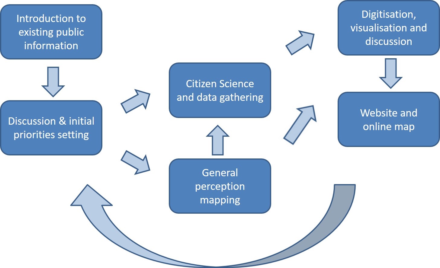 The methodology supports both participatory mapping and citizen science.
As we note in the chapter “Our methodology emerged in 2007, through the London 21 Sustainability Network project ‘A Fairer, Greener London’, which aimed to give six marginalised communities the opportunity to develop their own understanding of local environmental justice issues and supporting action plans to address them. The project was integrated closely with the project ‘Mapping Change for Sustainable Communities’ which was funded as part of the UrbanBuzz scheme. Both projects were based on accessible GIS technologies and available environmental information sources.
The methodology evolved into a six-stage process that is inherently flexible and iterative – so, while the stages are presented here as a serial process, the application of the methodology for a specific case is carried out through a discussion with the local community.” The chapter provides an example for the implementation of the methodology from the work that we carried out in the Pepys Estate.
If you want to read the whole chapter (and use the methodology, you can find it here. For any other chapter in the handbook, email the authors and they will probably share a copy with you.

![]()