
Exodus 2.0: Crowdsourcing Geographical and Social Trails of Mass Migration

To this end we recently had a paper published in the Journal of Geographical Systems entitled “Exodus 2.0: Crowdsourcing Geographical and Social Trails of Mass Migration“. We adopt the term Exodus 2.0 to refer to this new migration paradigm in the digital age, whereby information is a commodity in the migration process.
Given the nature of migration processes, it is possible to explore them across two key dimensions: geographical and situational. The geographical dimension is associated with the physical migration pathways migrants take from a country of origin to a destination site (often through a number of intermediate “stop” sites). The situational dimension is associated with the social connectivity of moving migrant populations, the conditions on the ground, and the activities that take place as part of migration efforts (including the root conditions, proximate conditions and triggering events).
 |
| Factors that potentially cause refugee production and mass movement based on identified factors detailed by Clark (1989) and Zottarelli (1998). |
Abstract:
The exodus of displaced populations is a recurring historical phenomenon, and the ongoing Syrian humanitarian crisis is its latest incarnation. During such mass migration events, information is an essential commodity. Of particular importance is geographical (e.g., pathways and refugee camps) and social (e.g., refugee activities and networking) information. Traditionally, such information had been produced and disseminated by authorities, but a new paradigm is emerging: Web 2.0 and mobile computing technologies enable the involved stakeholder communities to produce, access, and consume migration-related information. The purpose of this article is to put forward a new typology for understanding the factors around migration and to examine the potential of crowd-generated data—especially open data and volunteered geographic information—to study such events. Using the recent wave of migration to Europe from the Middle East and northern Africa as a case study, we examine how migration-related information can be dynamically mined and analyzed to study the migrants’ pathways from their home countries to their destination sites, as well as the conditions and activities that evolve during the migration process. These new data sources can provide a deeper and more fine-grained understanding of the migration process, often in real-time, and often through the eyes of the communities affected by it. Nevertheless, this also raises significant methodological and technical challenges for their future use associated with potential biases, data quality issues, and data processing.Keywords: Refugees, Forced migration, Humanitarian crisis, Volunteered geographic information, Crowdsourcing, Social media, GIS, Web 2.0.
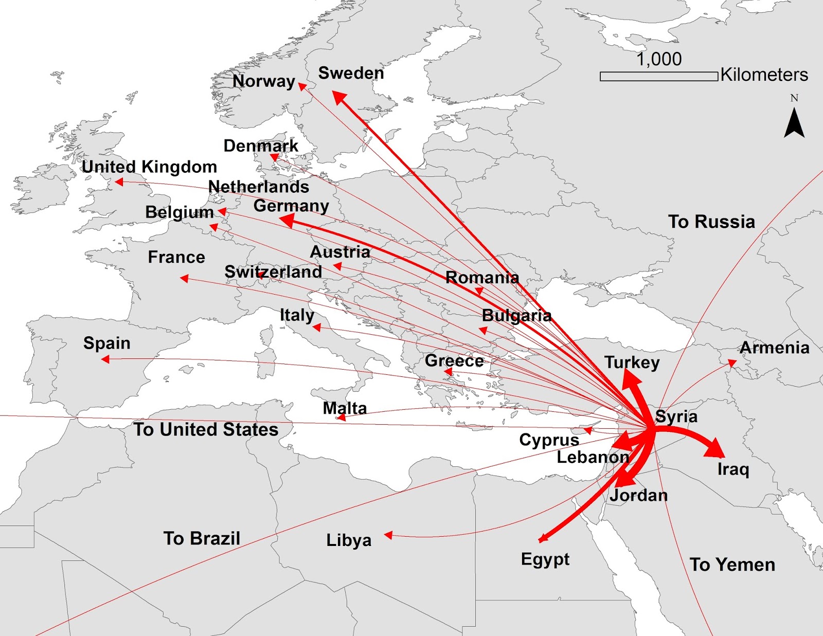 |
| Cumulative flow (2011–2015) illustrating Syrian forced migration to neighboring countries and other destination countries. Line thickness indicates increasing number of persons migrating. |

 |
| Retweet network of geolocated Twitter microblogs that are discussing opinions, news and retweeting information related to “refugee” in multiple languages from May to August 2017. |
 |
| A concept graph illustrating the associations between a keyword related to root factors of mass migration such as poverty (“welfare”) to other keywords, as they appear in our Twitter data corpus. The color of the node refers to specific themes: locations (green), actors (dark red), topics (red), entities and individuals (blue), concepts (white), and events (yellow). Red edges represent active associations between terms; gray edges represent inactive associations between terms. |
 |
| An agent-based model of migration: top: the spatial environment, where the lines represent migration pathways, and the nodes represent number of migrants. Purple nodes represent final destination sites, red nodes show migrant deaths, and green nodes show migrants en route (source: Hu 2016). |
Full Reference:
Curry, T., Croitoru, A., Crooks, A.T. and Stefanidis, A. (in press), Exodus 2.0: Crowdsourcing Geographical and Social Trails of Mass Migration, Journal of Geographical Systems. DOI: https://doi.org/10.1007/s10109-018-0278-1 (pdf)