Crowdsourcing Urban Form and Function

We have just had published a new paper entitled: “Crowdsourcing Urban Form and Function” in International Journal of Geographical Information Science which showcases some of our recent work with respect to cities and how new sources of information can be used to study urban morphology at a variety of spatial and temporal scales. Below is the abstract for the paper: 

“Urban form and function have been studied extensively in urban planning and geographic information science. However, gaining a greater understanding of how they merge to define the urban morphology remains a substantial scientific challenge. Towards this goal, this paper addresses the opportunities presented by the emergence of crowdsourced data to gain novel insights into form and function in urban spaces. We are focusing in particular on information harvested from social media and other open-source and volunteered datasets (e.g. trajectory and OpenStreetMap data). These data provide a first-hand account of form and function from the people who define urban space through their activities. This novel bottom-up approach to study these concepts complements traditional urban studies work to provide a new lens for studying urban activity. By synthesizing recent advancements in the analysis of open-source data we provide a new typology for characterizing the role of crowdsourcing in the study of urban morphology. We illustrate this new perspective by showing how social media, trajectory, and traffic data can be analyzed to capture the evolving nature of a city’s form and function. While these crowd contributions may be explicit or implicit in nature, they are giving rise to an emerging research agenda for monitoring, analyzing and modeling form and function for urban design and analysis.”

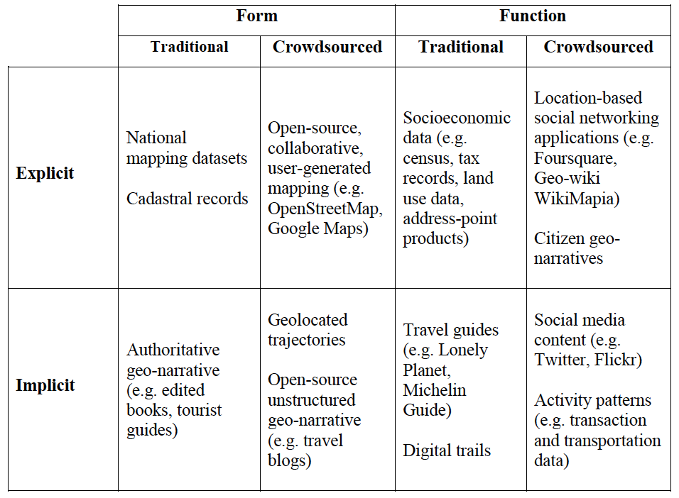
This paper builds and extends considerably our prior work, with respect to crowdsourcing, volunteered and ambient geographic information. In the scope of this paper we use the term ‘urban form’ to refer to the aggregate of the physical shape of the city, its buildings, streets, and all other elements that make up the urban space. In essence, the geometry of the city. In contrast, we use the term ‘urban function’ to refer to the activities that are taking place within this space. To this end we contrast how crowdsourced data can related to more traditional sources of such information both explicitly and implicitly as shown in the table below. 

A typology of implicit and explicit form and function content

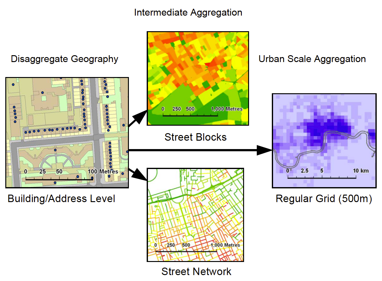
In addition, we also discuss in the paper how these new sources of data, which are often at finer resolutions than more authoritative data are allowing us to to customize the we we aggregate the data  at various geographical levels as shown below. Such aggregations can range from building footprints and addresses to street blocks (e.g. for density analysis), or street networks (e.g. for accessibility analysis). For large-scale urban analysis we can revert to the use of zonal geographies or grid systems.  
Aggregation methods for varied scales of built environment analysis

In the application section of the paper we highlight how we can extract implicit form and function from crowdsourced data. The image below for example, shows how we can take information from Twitter, and differentiate different neighborhoods over space and time.

Neighborhood map and topic modeling results showing the mixture of social functions in each area.
Finally in the paper, we outline an emerging research agenda related to the “persistent urban morphology concept” as shown below. Specifically how crowdsourcing is changing how we collect, analyze and model urban morphology. Moreover, how this new paradigm provides a new lens for studying the conceptualization of how cities operate, at much finer temporal, spatial, and social scales than we had been able to study so far.

The persistent urban morphology concept.

We hope you enjoy the paper.

Full Reference:  

Crooks, A.T., Pfoser, D., Jenkins, A., Croitoru, A., Stefanidis, A., Smith, D. A., Karagiorgou, S., Efentakis, A. and Lamprianidis, G. (2015), Crowdsourcing Urban Form and Function, International Journal of Geographical Information Science. DOI: 10.1080/13658816.2014.977905 (pdf)


Continue reading »

Citizens Observatories: Empowering European Society

A citizens observatory is a concept that evolved at EU policy circles, defining the combination of participatory community monitoring, technology and governance structures that are needed to monitor/observe/manage an environmental issue. About two years ago, the EU FP7 funded 5 citizens observatory projects covering areas from water management to biodiversity monitoring. A meeting at Brussels was […]

Continue reading »

International Encyclopedia of Geography – Quality Assurance of VGI

The Association of American Geographers is coordinating an effort to create an International Encyclopedia of Geography. Plans started in 2010, with an aim to see the 15 volumes project published in 2015 or 2016. Interestingly, this shows that publishers and scholars are still seeing the value in creating subject-specific encyclopedias. On the other hand, the weird […]

Continue reading »

Crowdsourced Geographic Information in Government

Today marks the publication of the report ‘crowdsourced geographic information in government‘. The report is the result of a collaboration that started in the autumn of last year, when the World Bank Global Facility for Disaster Reduction and Recovery(GFDRR)  requested to carry out a study of the way crowdsourced geographic information is used by governments. The […]

Continue reading »

Crowdsourcing, Citizen Science and INSPIRE

The INSPIRE 2014 conference marks the middle of the implementation process of  the INSPIRE directive (Infrastructure for Spatial Information in the European Community). The directive is aimed at establishing a pan-European Spatial Data Infrastructure (SDI), and that mean lots of blueprints, pipes, machine rooms and protocols for enabling the sharing of geographic information. In GIS jargon,  blueprints translate to […]

Continue reading »

Assertions on crowdsourced geographic information & citizen science #3

Following the two previous assertions, namely that: ‘you can be supported by a huge crowd for a very short time, or by few for a long time, but you can’t have a huge crowd all of the time (unless data collection is passive)’ (original post here) And ‘All information sources are heterogeneous, but some are more […]

Continue reading »

Assertions on crowdsourced geographic information & citizen science #2

Following the last post, which focused on an assertion about crowdsourced geographic information and citizen science I continue with another observation. As was noted in the previous post, these can be treated as ‘laws’ as they seem to emerge as common patterns from multiple projects in different areas of activity – from citizen science to crowdsourced […]

Continue reading »

New Publication: GIS and Agent-Based models for Humanitarian Assistance

Inputs to the model
 
As the readers of the blog know, we have an interest in GIS, agent-based modeling and crowdsourcing. Now we have a paper that combines all these three elements. Its entitled “GIS and Agent-Based models for Humanitarian Assistance” and is published in Computers, Environment and Urban Systems. 
 
The model itself was written in MASON and uses extensively GeoMASON. Data comes from several different sources (both raster and vector) including OpenStreetMap and LandScan. Below you can read an abstract of the paper and see a movie of one of the scenarios.

“Natural disasters such as earthquakes and tsunamis occur all over the world, altering the physical landscape and often severely disrupting people’s daily lives. Recently researchers’ attention has focused on using crowds of volunteers to help map the damaged infrastructure and devastation caused by natural disasters, such as those in Haiti and Pakistan. This data is extremely useful, as it is allows us to assess damage and thus aid the distribution of relief, but it tells us little about how the people in such areas will react to the devastation. This paper demonstrates a prototype spatially explicit agent-based model, created using crowdsourced geographic information and other sources of publicly available data, which can be used to study the aftermath of a catastrophic event. The specific case modelled here is the Haiti earthquake of January 2010. Crowdsourced data is used to build the initial populations of people affected by the event, to construct their environment, and to set their needs based on the damage to buildings. We explore how people react to the distribution of aid, as well as how rumours relating to aid availability propagate through the population. Such a model could potentially provide a link between socio-cultural information about the people affected and the relevant humanitarian relief organizations.”

Full Reference: 

Crooks, A.T. and Wise, S. (2013), GIS and Agent-Based models for Humanitarian Assistance, Computers, Environment and Urban Systems, 41: 100-111.

Continue reading »

The Guardian Science Weekly podcast dedicated to Citizen Science

The Guardian Science Weekly podcast is dedicated to Citizen Science – another example of the growing interest in popular media in Citizen Science. However, the podcast conflate cases were non-professional scientists are involved in scientific project (and Chris Lintott discuss Galaxy Zoo, FoldIt and similar projects) with participation in scientific research through surveys. It is […]

Continue reading »

Natural Disasters and Crowdsourcing: Haiti

Natural disasters such as earthquakes and tsunamis occur all over the world, altering the physical landscape and often severely disrupting people’s daily lives. Recently researchers’ attention has focused on using crowds of volunteers to help map the infrastructure and devastation caused by natural disasters, such as those in Haiti and Pakistan. For example, in the movie below shows the response to the earthquake by the OpenStreetMap community within 12 hours of the earthquake. The white flashes indicate edits to the map (often by tracing satellite/aerial photography).
While this data is extremely useful, as it is allows us to assess damage and thus aid the distribution of relief, but it tells us little about how the people in such areas will react to the devastation, the supply of food, or the reconstruction. To address this, we are exploring how agent-based modeling can be used to explore peoples reactions. To do this we have created a prototype spatially explicit agent-based model, created using crowdsourced geographic information and other sources of publicly available data, which can be used to study the aftermath of a catastrophic event. The specific case modeled here is the Haiti earthquake of January 2010. Crowdsourced data is used to build the initial populations of people affected by the event, to construct their environment, and to set their needs based on the damage to buildings. 

The idea behind the model is to explore how people react to the distribution of aid, as well as how rumors propagating through the population and crowding around aid distribution points might lead to food riots and similar social phenomena. Such a model could potentially provide a link between socio-cultural information of the people affected and relevant humanitarian relief organizations.

<p><p>sssss</p></p>

The animation above shows one simulation run where there is the spread of  information and agent movement (red dots) around one center (blue dot). While the chart below shows how over time the density of agents around the food station increases over time.

The idea behind such a model is one can take crowdsourced information and fuse it into an agent-based model and see how people will react to the distribution of food centers. For example, the movie below shows how agents find out about four (hypothetical) different food centers and decide whether or not to go to them in a 6 by 8km area of Port-au-Prince.

Spread of information and agent movement (red dots) in a 6 by 8km area of Port-au-Prince.
More details about this model to come……
Continue reading »

Crowd Funded Projects a Model for Planning?

The internet has opened up new resources for funding opportunities. Platforms to advertise projects and find sponsors and funders are developing fast. On such platform is Kickstarter, where developers can promote their project and ask for funding to develop prototyps and deliver products. Others are Go4funds, JustGiving or Profunder. They all have their specialities and niches but essentially they are all about projects and proposals that need to be funded.

A new project called Spacehive has come up in the UK with its own niche in this popular funding circus. The focus is on building projects as they call it neighbourhood improvement projects. As it says on the page “For people with inspiring project ideas, Spacehive allows you to pitch for support and funding from your community. For everyone else it’s a refreshingly easy way to transform where you live: just find a project you like and pledge a donation. If it gets funded, it gets built!”

The founder Chris Gourlay describes the Spacehive as the world’s first online funding platform for neighbourhood improvement projects. The project went live only last December (2011-12-07) and has so far listed a total of seven projects. These range from a Rooftop Aquatic Farm to a Dog Training Facility to the Community Centre project in Glyncoch.

As far as the projects range so do the costs. The platform has no cost restriction or a minimum. For examples the community centre wants to raise some £792,578 and the Revive North Pond project needs £42,320 or the Stokwell Urban Oasis needs only £2,952.

So far none of the projects have been successful. In fact the Glyncoch centre will be the first project to hit the dead line on the 30st of March. The projects currently needs a further £23’000 to go ahead next month. The next 22 days will be nerve racking for the project officials who desperately want their project to go ahead.

Infrastructure as architecture
Image taken from gka.org / The existing community centre in Glyncoch built in 1977. Could do with an update no question about that.

The media has already responded to the project and BBC has reported from Glyncoch after Steven Fry has tweeted about it. The social media is quick in picking stuff like this up and once more Twitter was the media of choice to discover the Spacehive platform. With over 4 million followers Steven Fry tweeting about it is great promotion and the community hopes this will bring the project the remaining money in funds they are short.

The projects are however not purely community funded. The Glyncoch project for examples has already had funding of 95% when is was listed on the Spacehive platform. This funding is Government money the village was promised for a new community centre. Only the remaining £30’000 the project team is trying to raise on the internet for the new centre to serve the 4’125 strong community.

Infrastructure as architecture
Image taken from spacehive.com / The newly proposed community centre for Glyncoch to be built for 7. There are no plans of or drawings, mentions of a program or what kind of facilities exactly it will offer. Its only a simple SketchUp image showig some building form the outside. Very difficult to see how it will unfold its qualities but it seems to be enough to try and rais substantial amounts of money.

Getting the public involved in local projects is nothing new interesting however, is the way the new trend on the internet is pushing terminologies and understandings of such projects. What does it mean if such a project for a community centre that is desperately needed is now promoted a crowd funded project. How does that change the responsibility previously carried by official government bodies and what does such a model mean for the next generation of urban project?

Platforms for crowd funded projects are nothing new as we have discussed above. THey work for software and app development, for products and now also have their big platform for art, but does it work for community projects? Can such a model replace the states responsibility to deliver and maintain standards in communities including infrastructure and facilities like a community centre.

The current UK Government will be very pleased if such a funding process takes off and becomes a model for other community project. It will mean that even in the delivery for public projects competition and free market can be introduced. Cameron could try and argue that the best promotion team could win any community the much deserved project with the add-on of ,if they can’t, they don’t deserve it. Let the crowd decide who needs what. It fits perfectly with the Tories plan to run schools privately as academies, privatise the police as outsources services to private security providers and now also let public projects be delivered privately.

Infrastructure as architecture
Image taken from spacehive.com / A project for A Roof-top Aquaponic Farm for London! producing fish and vegetables is one of the other projects looking for funders on the Spacehive platform. This project will need £45,602 to go ahead. The project is promoted by urbanFarmersUK a project related to urbanfarmers.ch a Group based in Zuerich, Switzerland.

A state and especially a planning and urban development does’t work like that. Values, excellence and quality are not something that is naturally delivered in the free market. Urban planners and practitioners have to stand for such qualities with their expertise. The future of our cities is not to be placed in the hands of lay people, for such important tasks experts should be put in place to develop such plans for the interest of the community.

The deliver should similarly be payed by the state or the local government using the taxes. People already pay a contribution to the community and this should be directed into such projects. The people from Glyncoch have all payed their tax towards this community centre and its not the point to now turn around and say well we are 30’000 short so all of your pay £10 extra and it will get payed. They already have payed!

Further more developing such funding options for urban development will change the responsibilities. The government will no longer be in charge and therefore also looses the power to controle what is happening. Who will be setting the standards and guidelines if the new road or bridge or dump is crowd funded? It will be very easy for large companies and businesses to manipulate such a process and get it don their way whilst ignoring all regulations and guidelines by pretending to work with the community.

Especially here in the UK it will be dramatic since the current development frameworks already are heavily influenced by private interests with the local authority and the government having very weak measures and tools to develop a community based vision. Other countries such as Germany, the Netherlands and Switzerland have much better developed frameworks and instruments for urban planning and community development.

It will be vital to strengthen the public official in delivering such community projects and bring back authority to plan ahead and deliver. This is the only way for consistent and sustainable development of the communities through out the country. The public can privatise these responsibilities they have to remain in the powers of the authorities.

Continue reading »

Crowd Funded Projects a Model for Planning?

The internet has opened up new resources for funding opportunities. Platforms to advertise projects and find sponsors and funders are developing fast. On such platform is Kickstarter, where developers can promote their project and ask for funding to develop prototyps and deliver products. Others are Go4funds, JustGiving or Profunder. They all have their specialities and niches but essentially they are all about projects and proposals that need to be funded.

A new project called Spacehive has come up in the UK with its own niche in this popular funding circus. The focus is on building projects as they call it neighbourhood improvement projects. As it says on the page “For people with inspiring project ideas, Spacehive allows you to pitch for support and funding from your community. For everyone else it’s a refreshingly easy way to transform where you live: just find a project you like and pledge a donation. If it gets funded, it gets built!”

The founder Chris Gourlay describes the Spacehive as the world’s first online funding platform for neighbourhood improvement projects. The project went live only last December (2011-12-07) and has so far listed a total of seven projects. These range from a Rooftop Aquatic Farm to a Dog Training Facility to the Community Centre project in Glyncoch.

As far as the projects range so do the costs. The platform has no cost restriction or a minimum. For examples the community centre wants to raise some £792,578 and the Revive North Pond project needs £42,320 or the Stokwell Urban Oasis needs only £2,952.

So far none of the projects have been successful. In fact the Glyncoch centre will be the first project to hit the dead line on the 30st of March. The projects currently needs a further £23’000 to go ahead next month. The next 22 days will be nerve racking for the project officials who desperately want their project to go ahead.

Infrastructure as architecture
Image taken from gka.org / The existing community centre in Glyncoch built in 1977. Could do with an update no question about that.

The media has already responded to the project and BBC has reported from Glyncoch after Steven Fry has tweeted about it. The social media is quick in picking stuff like this up and once more Twitter was the media of choice to discover the Spacehive platform. With over 4 million followers Steven Fry tweeting about it is great promotion and the community hopes this will bring the project the remaining money in funds they are short.

The projects are however not purely community funded. The Glyncoch project for examples has already had funding of 95% when is was listed on the Spacehive platform. This funding is Government money the village was promised for a new community centre. Only the remaining £30’000 the project team is trying to raise on the internet for the new centre to serve the 4’125 strong community.

Infrastructure as architecture
Image taken from spacehive.com / The newly proposed community centre for Glyncoch to be built for 7. There are no plans of or drawings, mentions of a program or what kind of facilities exactly it will offer. Its only a simple SketchUp image showig some building form the outside. Very difficult to see how it will unfold its qualities but it seems to be enough to try and rais substantial amounts of money.

Getting the public involved in local projects is nothing new interesting however, is the way the new trend on the internet is pushing terminologies and understandings of such projects. What does it mean if such a project for a community centre that is desperately needed is now promoted a crowd funded project. How does that change the responsibility previously carried by official government bodies and what does such a model mean for the next generation of urban project?

Platforms for crowd funded projects are nothing new as we have discussed above. THey work for software and app development, for products and now also have their big platform for art, but does it work for community projects? Can such a model replace the states responsibility to deliver and maintain standards in communities including infrastructure and facilities like a community centre.

The current UK Government will be very pleased if such a funding process takes off and becomes a model for other community project. It will mean that even in the delivery for public projects competition and free market can be introduced. Cameron could try and argue that the best promotion team could win any community the much deserved project with the add-on of ,if they can’t, they don’t deserve it. Let the crowd decide who needs what. It fits perfectly with the Tories plan to run schools privately as academies, privatise the police as outsources services to private security providers and now also let public projects be delivered privately.

Infrastructure as architecture
Image taken from spacehive.com / A project for A Roof-top Aquaponic Farm for London! producing fish and vegetables is one of the other projects looking for funders on the Spacehive platform. This project will need £45,602 to go ahead. The project is promoted by urbanFarmersUK a project related to urbanfarmers.ch a Group based in Zuerich, Switzerland.

A state and especially a planning and urban development does’t work like that. Values, excellence and quality are not something that is naturally delivered in the free market. Urban planners and practitioners have to stand for such qualities with their expertise. The future of our cities is not to be placed in the hands of lay people, for such important tasks experts should be put in place to develop such plans for the interest of the community.

The deliver should similarly be payed by the state or the local government using the taxes. People already pay a contribution to the community and this should be directed into such projects. The people from Glyncoch have all payed their tax towards this community centre and its not the point to now turn around and say well we are 30’000 short so all of your pay £10 extra and it will get payed. They already have payed!

Further more developing such funding options for urban development will change the responsibilities. The government will no longer be in charge and therefore also looses the power to controle what is happening. Who will be setting the standards and guidelines if the new road or bridge or dump is crowd funded? It will be very easy for large companies and businesses to manipulate such a process and get it don their way whilst ignoring all regulations and guidelines by pretending to work with the community.

Especially here in the UK it will be dramatic since the current development frameworks already are heavily influenced by private interests with the local authority and the government having very weak measures and tools to develop a community based vision. Other countries such as Germany, the Netherlands and Switzerland have much better developed frameworks and instruments for urban planning and community development.

It will be vital to strengthen the public official in delivering such community projects and bring back authority to plan ahead and deliver. This is the only way for consistent and sustainable development of the communities through out the country. The public can privatise these responsibilities they have to remain in the powers of the authorities.

Continue reading »
1 2