New Paper: ABM Applied to the Spread of Cholera

Cholera transmission through the interaction
of host and the environment
We are pleased to announce we have just had a paper published in Environmental Modelling and Software entitled “An Agent-based Modeling Approach Applied to the Spread of Cholera
Research highlights include:
  • An agent-based model was developed to explore the spread of cholera.
  • The progress of cholera transmission is represented through a Susceptible-Exposed-Infected-Recovered (SEIR) model. 
  • The model integrates geographical data with agents’ daily activities within a refugee camp.
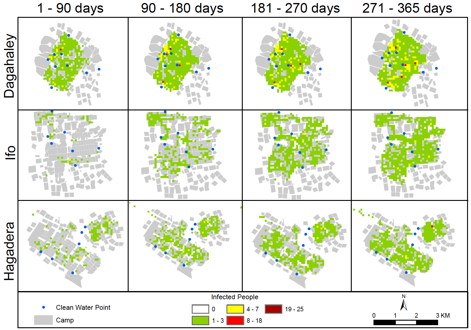
  • Results show cholera infections are impacted by agents’ movement and source of contamination. 
  • The model has the potential for aiding humanitarian response with respect to disease outbreaks.
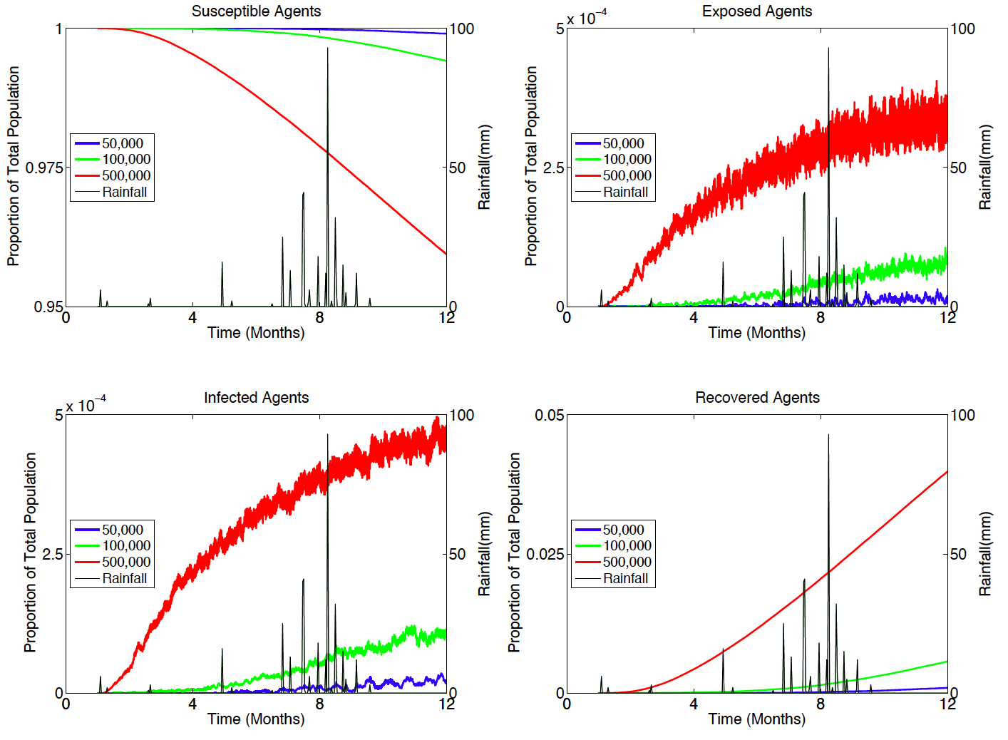
Cholera dynamics when rainfall is introduced.

Spatial spread of cholera over the course of a year.
Study area
If the research highlights have not turned you off, the abstract to the paper is below:
“Cholera is an intestinal disease and is characterized by diarrhea and severe dehydration. While cholera has mainly been eliminated in regions that can provide clean water, adequate hygiene and proper sanitation; it remains a constant threat in many parts of Africa and Asia. Within this paper, we develop an agent-based model that explores the spread of cholera in the Dadaab refugee camp in Kenya. Poor sanitation and housing conditions contribute to frequent incidents of cholera outbreaks within this camp. We model the spread of cholera by explicitly representing the interaction between humans and their environment, and the spread of the epidemic using a Susceptible-Exposed-Infected-Recovered model. Results from the model show that the spread of cholera grows radially from contaminated water sources and seasonal rains can cause the emergence of cholera outbreaks. This modeling effort highlights the potential of agent-based modeling to explore the spread of cholera in a humanitarian context.”
Finally to aide replication, experimentation or just explore how you can link raster and vector data in GeoMason, we have a dedicated website where you can download executables of the model along with the source code and associated data. Moreover we have provide a really detailed Overview, Design concepts, and Details (ODD) Protocol document of the model.

Full Reference:

Crooks, A.T. and Hailegiorgis, A.B. (2014), An Agent-based Modeling Approach Applied to the Spread of Cholera, Environmental Modelling and Software, 62: 164-177
DOI: 10.1016/j.envsoft.2014.08.027 (pdf)

Continue reading »

Call for Papers: New Directions in Geospatial Simulation

New Directions In Geospatial Simulation
The geospatial simulation community has enjoyed steady growth over the past decade as novel and advanced forms of agent-based and cellular automata modeling continue to facilitate the exploration of complex geographic problems facing the world today. It is now an opportune time to consider the future direction of this community and explore ways to leverage geospatial simulation in professional arenas. The aim of these sessions is to bring together researchers utilizing agent-based and cellular automata techniques and associated methodologies to discuss new directions in geospatial simulation. We invite papers that fall into one of the following four categories:
  • Graduate student geospatial simulation research
  • Methodological advances of agent-based or cellular automata modeling
  • New application frontiers in geospatial simulation
  • Approaches for evaluating the credibility of geospatial simulation models
Student papers will be presented in an interactive short paper session with presentations no longer than five minutes and no more than ten slides. Following presentations, students will form a panel that will address questions from the audience as directed by the session moderator. Student presentations will be judged as a part of a Best Student Paper award, the winner of which will receive an award of $500.
All other papers will be placed in one of the following three sessions: (1) Methodological Advances, (2) Novel Applications, or (3) Model Credibility. Each session will be comprised of four speakers followed by a twenty-minute discussion on the session topic.
Please e-mail the abstract and key words with your expression of intent to Chris Bone by October 28, 2014. Please make sure that your abstract conforms to the AAG guidelines in relation to title, word limit and key words and as specified at http://www.aag.org/cs/annualmeeting/call_for_papers. An abstract should be no more than 250 words that describe the presentation’s purpose, methods, and conclusions as well as to include keywords. Full submissions will be given priority over submissions with just a paper title.
ORGANIZERS:
Chris Bone, Department of Geography, University of Oregon
Andrew Crooks, Department of Computational Social Science, George Mason University
Alison Heppenstall, School of Geography, University of Leeds
Arika Ligmann-Zielinska, Department of Geography, Michigan State University
David O’Sullivan, Department of Geography, University of California, Berkeley
TIMELINE:
October 14th, 2014: Second call for papers
October 28th, 2014: Abstract submission and expression of intent to session organizers. E-mail Chris Bone by this date if you are interested in being in this session. Please submit an abstract and key words with your expression of intent. Full submissions will be given priority over submissions with just a paper title.
October 31st, 2014: Session finalization. Session organizers determine session order and content and notify authors.
November 3rd, 2014: Final abstract submission to AAG, via www.aag.org. All participants must register individually via this site. Upon registration you will be given a participant number (PIN). Send the PIN and a copy of your final abstract to Chris Bone. Neither the organizers nor the AAG will edit the abstracts.

November 5th, 2014: AAG registration deadline. Sessions submitted to AAG for approval.
April 21-25, 2014: AAG meeting, Chicago, Illinois, USA.

Continue reading »

Call for Papers: New Directions in Geospatial Simulation

New Directions In Geospatial Simulation
The geospatial simulation community has enjoyed steady growth over the past decade as novel and advanced forms of agent-based and cellular automata modeling continue to facilitate the exploration of complex geographic problems facing the world today. It is now an opportune time to consider the future direction of this community and explore ways to leverage geospatial simulation in professional arenas. The aim of these sessions is to bring together researchers utilizing agent-based and cellular automata techniques and associated methodologies to discuss new directions in geospatial simulation. We invite papers that fall into one of the following four categories:
  • Graduate student geospatial simulation research
  • Methodological advances of agent-based or cellular automata modeling
  • New application frontiers in geospatial simulation
  • Approaches for evaluating the credibility of geospatial simulation models
Student papers will be presented in an interactive short paper session with presentations no longer than five minutes and no more than ten slides. Following presentations, students will form a panel that will address questions from the audience as directed by the session moderator. Student presentations will be judged as a part of a Best Student Paper award, the winner of which will receive an award of $500.
All other papers will be placed in one of the following three sessions: (1) Methodological Advances, (2) Novel Applications, or (3) Model Credibility. Each session will be comprised of four speakers followed by a twenty-minute discussion on the session topic.
Please e-mail the abstract and key words with your expression of intent to Chris Bone by October 28, 2014. Please make sure that your abstract conforms to the AAG guidelines in relation to title, word limit and key words and as specified at http://www.aag.org/cs/annualmeeting/call_for_papers. An abstract should be no more than 250 words that describe the presentation’s purpose, methods, and conclusions as well as to include keywords. Full submissions will be given priority over submissions with just a paper title.
ORGANIZERS:
Chris Bone, Department of Geography, University of Oregon
Andrew Crooks, Department of Computational Social Science, George Mason University
Alison Heppenstall, School of Geography, University of Leeds
Arika Ligmann-Zielinska, Department of Geography, Michigan State University
David O’Sullivan, Department of Geography, University of California, Berkeley
TIMELINE:
October 14th, 2014: Second call for papers
October 28th, 2014: Abstract submission and expression of intent to session organizers. E-mail Chris Bone by this date if you are interested in being in this session. Please submit an abstract and key words with your expression of intent. Full submissions will be given priority over submissions with just a paper title.
October 31st, 2014: Session finalization. Session organizers determine session order and content and notify authors.
November 3rd, 2014: Final abstract submission to AAG, via www.aag.org. All participants must register individually via this site. Upon registration you will be given a participant number (PIN). Send the PIN and a copy of your final abstract to Chris Bone. Neither the organizers nor the AAG will edit the abstracts.

November 5th, 2014: AAG registration deadline. Sessions submitted to AAG for approval.
April 21-25, 2014: AAG meeting, Chicago, Illinois, USA.

Continue reading »

Special Sessions on GeoComputation @ NARSC

–>

Second Call for participation
Special Sessions on GeoComputation
61st Annual North American Meetings of the Regional Science Association International NARSC – RSAI
November 12-15, 2014, Washington, DC, USA
The special sessions on various aspects of GeoComputation are planned for the North American Meetings of the Regional Science Association International (NARSC) to be held in Washington DC, USA, November 12-15, 2014. Suitable topics for the session presentations are theoretical, methodological and applied issues related to GeoComputation – spatial analysis and modeling, and in the context of regional science.
Please let us know if you are interested to contribute to the special session(s) by sending an email at <suzanad@sfu.ca> with the title, abstract, name of author(s), affiliations, contact details and the unique ID number at your earliest but not later than June 25th, 2014. The abstract should be 2,000 to 5,500 characters and spaces.
Please note that in order to have your presentation included to the special session we do need the unique identification number (ID). The ID, or PIN, is a number included at the bottom of the confirmation email received following the submission of an abstract.
Detailed information about the NARSC conference can be found at . Information about the submission process can be found at . Conference abstract submission deadline is July 1st, 2014.
Looking forward to seeing you in Washington, DC.
The organizers:
Prof. Suzana Dragićević
Department of Geography
Simon Fraser University, Canada
Email: suzanad@sfu.ca
Prof. Andrew Crooks
Department of Computational Social Science
George Mason University, USA
Email: acrooks2@gmu.edu
Prof. Jean-Claude Thill
Department of Geography and Earth Sciences
University of North Carolina at Charlotte, USA
Email: Jean-Claude.Thill@uncc.edu
Continue reading »

Multi-Agent Systems for Urban Planning

Recently we contributed a chapter to “Technologies for Urban and Spatial Planning: Virtual Cities and Territories” which aims to quote from the preference:  

“(i) to contribute to the dissemination of the recent research and development of the use of information and communication technologies (ICT) in urban and spatial planning, trying to demonstrate their usability in planning processes through the presentation of relevant case studies, framed by their underlying theory; (ii) to give additional evidence to the fact that ICT are the privileged means to produce virtual cities and territories; and (iii) to make available, from a pedagogical standpoint, a group of illustrative reviews of the scientific production made by both academics and practitioners in the field.”

The book has 11 chapters which are grouped in several themes:

“first group focuses on the discussion over the use of ICT in spatial planning; the second group of contributions deals with urban modelling and simulation; the third group focuses on the use of different sensors to acquire information and model spatial processes; the fourth group focuses on the use of data to create more capable visualization tools; and the fifth group is about the use of virtual models to simulate real environments and plan and manage other aspects of the built environment such as energy.”

Our chapter is entitled “Multi-agent Systems for Urban Planning” fits into the second group with respect to urban modeling and simulation. We present a detailed overview about the theory and the development of multi-agent systems (MAS) in spatial planning, focusing on how MAS can lead to insights into urban problems and aid urban planning fostering a bottom up approach to spatial planning. The abstract is as follows:
Cities provide homes for over half of the world’s population, and this proportion is expected to increase throughout the next century. The growth of cities raises many questions and challenges for urban planning including which cities and regions are most likely to grow, what the pattern of urban growth will be, and how the existing infrastructure will cope with such growth. One way to explore these types of questions is through the use of multi-agent systems (MAS) that are capable of modeling how individuals interact and how structures emerge through such interactions, in terms of both the social and physical environment of cities. Within this chapter, the authors focus on how MAS can lead to insights into urban problems and aid urban planning from the bottom up. They review MAS models that explore the growth of cities and regions, models that explore land-use patterns resulting from such growth along with the rise of slums. Furthermore, the authors demonstrate how MAS models can be used to model transportation and the changing demographics of cities. Through these examples the authors also demonstrate how this style of modeling can give insights into such issues that cannot be gleamed from other modeling methodologies. The chapter concludes with challenges and future research directions of MAS models with respect to capturing the dynamics of human behavior in urban planning.

Full Reference:

Crooks, A.T., Patel, A. and Wise, S. (2014), Multi-agent Systems for Urban Planning, in Pinto, N.N., Tenedório, J. Antunes A. P. and Roca, J. (eds.), Technologies for Urban and Spatial Planning: Virtual Cities and Territories, IGI Global, Hershey, PA, pp. 29-56. (pdf)

Continue reading »

AAG 2014: Geosimulation Models Sessions

If you going to this years AAG, you might be interested in our Geosimulation Models sessions which will take place on Wednesday the 9th of April from 10am.

Session Description: Since the publication of Geosimulation in 2004, the use of Agent-based Modeling (ABM) and Cellular Automata (CA) under the umbrella of Geosimulation models within geographical systems have started to mature as methodologies to explore a wide range of geographical and more broadly social sciences problems facing society. The aim of these sessions is to bring together researchers utilizing geosimulation techniques (and associated methodologies) to discuss topics relating to: theory, technical issues and applications domains of ABM and CA within geographical systems.

10:00 AM to 11:40,  Room 39, TCC, Fourth Floor , Chair: Suzana Dragicevic
12.40PM to 2.20PM, Room 39, TCC, Fourth Floor, Chair: Paul Torrens
2:40 PM to 4:20 PM in Room 39, TCC, Fourth Floor, Chair: Paul Torrens
Siyu Fan and Yichun Xie

We would also like to thank the following AAG specialty groups for sponsoring our sessions: Spatial Analysis and Modeling Specialty GroupCyberinfrastructure Specialty Group and the Geographic Information Science and Systems Specialty Group  
Continue reading »

A Framework for Agent-based Model Design

Model design is one of the most important stages of the development of any agent-based model.  Get the design wrong and you might find yourself tied up in knots, battling against the structure of the project you defined months before.  Get it right and you’ll leave yourself a extensible platform to develop into, allowing yourself …
Read more

Continue reading »

Interurban Simulation Models

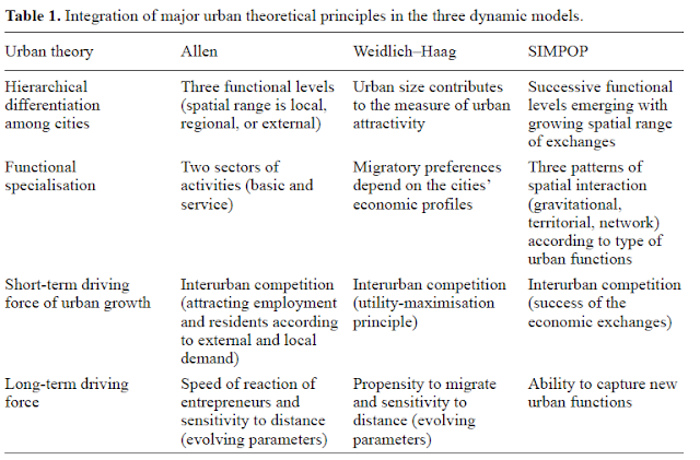
Following on from a previous post about the rise of civilizations. I thought it was worth blogging of another publication which I just came across in Environment and Planning A which demonstrates the utility of agent-based modeling for looking at urban systems by Denise Pumain and Lena Sanders. While I have blogged about the SimPop models before (here), which explore a systems of cities and how they evolve in space and time. In this recent paper the authors compare and contrast ABM with other styles of modeling. To quote from the paper:

“Agent-based models are increasingly used by urban specialists, supplanting the simulation models using differential equations which were more popular earlier. These models already made reference to the theories of self-organisation and to mechanisms of evolution not so far from those used today to describe the emergence of macroscopic properties or structures in a bottom-up process from interactions operating at the microlevel. Moreover there is less difference than often suggested in the literature between the two forms of modelling – differential equations and multi-agent models—in the way they integrate principles of urban theory. To test this assumption, we compare models made of systems of differential equations (Allen’s model firmly rooted in self-organisation theory and the model developed by Weidlich and Haag, affiliated to synergetic theory) with multi-agent models (SIMPOP family) designed to meet the same task: simulating the differentiated dynamics of urban entities over the medium to long term from their functional economic specialisation. We show that multi-agent systems are providing interesting solutions for the modelling method, because of their greater ability to simulate the emergence of geographical macro structures from different levels of interaction.” 

Full Reference:

Pumain, D. and  Sanders, L. (2013). Theoretical principles in interurban simulation models: a comparison. Environment and Planning A, 45(9), 2243-2260.


Continue reading »
Interurban Simulation Models

Following on from a previous post about the rise of civilizations. I thought it was worth blogging of another publication which I just came across in Environment and Planning A which demonstrates the utility of agent-based modeling for looking at urban systems by Denise Pumain and Lena Sanders. While I have blogged about the SimPop models before (here), which explore a systems of cities and how they evolve in space and time. In this recent paper the authors compare and contrast ABM with other styles of modeling. To quote from the paper:

“Agent-based models are increasingly used by urban specialists, supplanting the simulation models using differential equations which were more popular earlier. These models already made reference to the theories of self-organisation and to mechanisms of evolution not so far from those used today to describe the emergence of macroscopic properties or structures in a bottom-up process from interactions operating at the microlevel. Moreover there is less difference than often suggested in the literature between the two forms of modelling – differential equations and multi-agent models—in the way they integrate principles of urban theory. To test this assumption, we compare models made of systems of differential equations (Allen’s model firmly rooted in self-organisation theory and the model developed by Weidlich and Haag, affiliated to synergetic theory) with multi-agent models (SIMPOP family) designed to meet the same task: simulating the differentiated dynamics of urban entities over the medium to long term from their functional economic specialisation. We show that multi-agent systems are providing interesting solutions for the modelling method, because of their greater ability to simulate the emergence of geographical macro structures from different levels of interaction.” 

Full Reference:

Pumain, D. and  Sanders, L. (2013). Theoretical principles in interurban simulation models: a comparison. Environment and Planning A, 45(9), 2243-2260.


Continue reading »

ODD with human decision-making

In the Department of CSS, we often encourage our students when writing term papers (or any paper) with respect to agent-based models to use the Overview, Design concepts, and Details (ODD) Protocol (Grimm et al., 2006). This relates to the fact that is not only challenging building an agent-based model but also describing the model in enough detail to all for replication or comparison. Müller et al., (2013) have recently extended to ODD so that it is easier to have a standard way of describing decsion making within agent-based models.The paper is well worth a read.

Original Overview, Design concepts, and Details (ODD) protocol (Source: Grimm et al., 2006).

Extended ODD for describing human decisions in agent-based models – ODD + D (Source: Müller et al., 2013)

Full references to the papers:

Grimm, V., Berger, U., Bastiansen, F., Eliassen, S., Ginot, V., Giske, J., Goss-Custard, J., Grand, T., Heinz, S., Huse, G., Huth, A., Jepsen, J., Jorgensen, C., Mooij, W., Muller, B., Pe’er, G., Piou, C., Railsback, S., Robbins, A., Robbins, M., Rossmanith, E., Ruger, N., Strand, E., Souissi, S., Stillman, R., Vabo, R., Visser, U. and Deangelis, D. (2006),A Standard Protocol for Describing Individual-Based and Agent-Based Models‘, Ecological Modelling, 198(1-2): 115–126.

Müller, B., Bohn, F., Dreßler, G., Groeneveld, J., Klassert, C., Martin, R., Schlüter, M., Schulze, J., Weise, H. and Schwarz, N. (2013),Describing Human Decisions in Agent-based Models – ODD + D, An Extension of the ODD Protocol‘, Environmental Modelling and Software, 48: 37-48.

Continue reading »

ODD with human decision-making

In the Department of CSS, we often encourage our students when writing term papers (or any paper) with respect to agent-based models to use the Overview, Design concepts, and Details (ODD) Protocol (Grimm et al., 2006). This relates to the fact that is not only challenging building an agent-based model but also describing the model in enough detail to all for replication or comparison. Müller et al., (2013) have recently extended to ODD so that it is easier to have a standard way of describing decsion making within agent-based models.The paper is well worth a read.

Original Overview, Design concepts, and Details (ODD) protocol (Source: Grimm et al., 2006).

Extended ODD for describing human decisions in agent-based models – ODD + D (Source: Müller et al., 2013)

Full references to the papers:

Grimm, V., Berger, U., Bastiansen, F., Eliassen, S., Ginot, V., Giske, J., Goss-Custard, J., Grand, T., Heinz, S., Huse, G., Huth, A., Jepsen, J., Jorgensen, C., Mooij, W., Muller, B., Pe’er, G., Piou, C., Railsback, S., Robbins, A., Robbins, M., Rossmanith, E., Ruger, N., Strand, E., Souissi, S., Stillman, R., Vabo, R., Visser, U. and Deangelis, D. (2006),A Standard Protocol for Describing Individual-Based and Agent-Based Models‘, Ecological Modelling, 198(1-2): 115–126.

Müller, B., Bohn, F., Dreßler, G., Groeneveld, J., Klassert, C., Martin, R., Schlüter, M., Schulze, J., Weise, H. and Schwarz, N. (2013),Describing Human Decisions in Agent-based Models – ODD + D, An Extension of the ODD Protocol‘, Environmental Modelling and Software, 48: 37-48.

Continue reading »
1 2 3 4 5 6