A Review of High and Very High Resolution Remote Sensing Approaches for Detecting and Mapping Slums

Regular readers of this site might of noticed that we have an interest in slums. In the past this has focused on modeling them from an agent-based perspective, comparing volunteered geographical information to more authoritative data on slums, to that …

Continue reading »

Modeling the Emergence of Riots: A Geosimulation Approach

As you might of guessed the paper is about riots but that is not all. In the paper we have a highly detailed cognitive model implemented through the PECS (Physical conditions, Emotional state, Cognitive capabilities, and Social status) framework based around identity theory. The purpose of the model (and paper) is to explore how the unique socioeconomic variables underlying Kibera, a slum in Nairobi, coupled with local interactions of its residents, and the spread of a rumor, may trigger a riot such as those seen in 2007. 
In order to explore this question from the “bottom up” we have developed a novel agent-based model that integrates social network analysis (SNA) and geographic information systems (GIS) for this purpose. In the paper we argue that this integration facilitates the modeling of dynamic social networks created through the agents’ daily interactions. The GIS is used to develop a realistic environment for agents to move and interact that includes a road network and points of interest which impact their daily lives.
Below is the abstract and a summary of its highlights in order to give you a sense of what our research contribution is. In addition to this we also provide some images either from the paper itself or the from Overview, Design Concepts, and Details (ODD) protocol. Finally at the bottom of this post you can see one of the simulation runs, details of where the model can be downloaded along with the full citation.

Paper Abstract:

Immediately after the 2007 Kenyan election results were announced, the country erupted in protest. Riots were particularly severe in Kibera, an informal settlement located within the nations capital, Nairobi. Through the lens of geosimulation, an agent-based model is integrated with social network analysis and geographic information systems to explore how the environment and local interactions underlying Kibera, combined with an external trigger, such as a rumor, led to the emergence of riots. We ground our model on empirical data of Kibera’s geospatial landscape, heterogeneous population, and daily activities of its residents. In order to effectively construct a model of riots, however, we must have an understanding of human behavior, especially that related to an individual’s need for identity and the role rumors play on a person’s decision to riot. This provided the foundation to develop the agents’ cognitive model, which created a feedback system between the agents’ activities in physical space and interactions in social space. Results showed that youth are more susceptible to rioting. Systematically increasing education and employment opportunities, however, did not have simple linear effects on rioting, or even on quality of life with respect to income and activities. The situation is more complex. By linking agent-based modeling, social network analysis, and geographic information systems we were able to develop a cognitive framework for the agents, better represent human behavior by modeling the interactions that occur over both physical and social space, and capture the nonlinear, reinforcing nature of the emergence and dissolution of riots.

Keywords: agent-based modeling; geographic information systems; social network analysis; riots; social influence; rumor propagation.

Paper Highlights:

  • An agent-based model integrates geographic information systems and social network analysis to model the emergence of riots. 
  • The physical environment and agent attributes are developed using empirical data, including GIS and socioeconomic data. 
  • The agent’s cognitive framework allowed for modeling their activities in physical space and interactions in social space. 
  • Through the integration of the three techniques, we were able to capture the complex, nonlinear nature of riots. 
  • Results show that youth are most vulnerable, and, increasing education and employment has nonlinear affects on rioting.
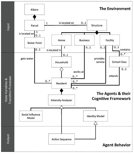
The high-level UML diagram of the model
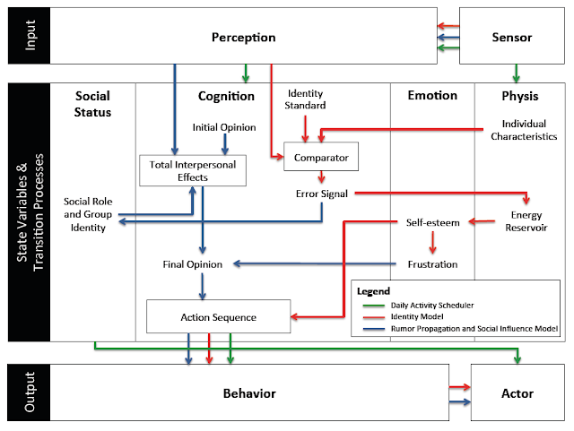
A high-level representation of the model’s agent behavior incorporated into the PECS framework

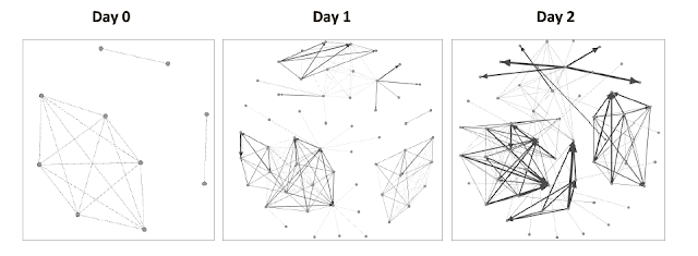
An example of the evolution of social networks of ten Residents across the first two days of a simulation run.

The movie below shows the agent-based model which explores ethnic clashes in the Kenyan slum. The environment is made up of households, businesses, and service facilities (such data comes from OpenStreetMap). Agents within the model use a transportation network to move across the environment. As agents go about their daily activities, they interact with other agents – building out an evolving social network. Agents seek to meet their identity standard. Failure to reach their identity standard increases the agents frustration which can lead to an aggressive response (i.e. moving from blue to red color) such as rioting.

As with many of our models, we provide the data, model code and detailed model description in the form of the ODD protocol for others to use, learn more or to extend. Click here for more information.

Full Reference:

Pires, B. and Crooks, A.T. (2017), Modeling the Emergence of Riots: A Geosimulation Approach, Computers, Environment and Urban Systems, 61: 66-80. (pdf)

As normal, any thoughts or comments are most appreciated.
 

Continue reading »

Modeling the Emergence of Riots: A Geosimulation Approach

As you might of guessed the paper is about riots but that is not all. In the paper we have a highly detailed cognitive model implemented through the PECS (Physical conditions, Emotional state, Cognitive capabilities, and Social status) framework based around identity theory. The purpose of the model (and paper) is to explore how the unique socioeconomic variables underlying Kibera, a slum in Nairobi, coupled with local interactions of its residents, and the spread of a rumor, may trigger a riot such as those seen in 2007. 
In order to explore this question from the “bottom up” we have developed a novel agent-based model that integrates social network analysis (SNA) and geographic information systems (GIS) for this purpose. In the paper we argue that this integration facilitates the modeling of dynamic social networks created through the agents’ daily interactions. The GIS is used to develop a realistic environment for agents to move and interact that includes a road network and points of interest which impact their daily lives.
Below is the abstract and a summary of its highlights in order to give you a sense of what our research contribution is. In addition to this we also provide some images either from the paper itself or the from Overview, Design Concepts, and Details (ODD) protocol. Finally at the bottom of this post you can see one of the simulation runs, details of where the model can be downloaded along with the full citation.

Paper Abstract:

Immediately after the 2007 Kenyan election results were announced, the country erupted in protest. Riots were particularly severe in Kibera, an informal settlement located within the nations capital, Nairobi. Through the lens of geosimulation, an agent-based model is integrated with social network analysis and geographic information systems to explore how the environment and local interactions underlying Kibera, combined with an external trigger, such as a rumor, led to the emergence of riots. We ground our model on empirical data of Kibera’s geospatial landscape, heterogeneous population, and daily activities of its residents. In order to effectively construct a model of riots, however, we must have an understanding of human behavior, especially that related to an individual’s need for identity and the role rumors play on a person’s decision to riot. This provided the foundation to develop the agents’ cognitive model, which created a feedback system between the agents’ activities in physical space and interactions in social space. Results showed that youth are more susceptible to rioting. Systematically increasing education and employment opportunities, however, did not have simple linear effects on rioting, or even on quality of life with respect to income and activities. The situation is more complex. By linking agent-based modeling, social network analysis, and geographic information systems we were able to develop a cognitive framework for the agents, better represent human behavior by modeling the interactions that occur over both physical and social space, and capture the nonlinear, reinforcing nature of the emergence and dissolution of riots.

Keywords: agent-based modeling; geographic information systems; social network analysis; riots; social influence; rumor propagation.

Paper Highlights:

  • An agent-based model integrates geographic information systems and social network analysis to model the emergence of riots. 
  • The physical environment and agent attributes are developed using empirical data, including GIS and socioeconomic data. 
  • The agent’s cognitive framework allowed for modeling their activities in physical space and interactions in social space. 
  • Through the integration of the three techniques, we were able to capture the complex, nonlinear nature of riots. 
  • Results show that youth are most vulnerable, and, increasing education and employment has nonlinear affects on rioting.

The high-level UML diagram of the model
A high-level representation of the model’s agent behavior incorporated into the PECS framework

An example of the evolution of social networks of ten Residents across the first two days of a simulation run.

The movie below shows the agent-based model which explores ethnic clashes in the Kenyan slum. The environment is made up of households, businesses, and service facilities (such data comes from OpenStreetMap). Agents within the model use a transportation network to move across the environment. As agents go about their daily activities, they interact with other agents – building out an evolving social network. Agents seek to meet their identity standard. Failure to reach their identity standard increases the agents frustration which can lead to an aggressive response (i.e. moving from blue to red color) such as rioting.

As with many of our models, we provide the data, model code and detailed model description in the form of the ODD protocol for others to use, learn more or to extend. Click here for more information.

Full Reference:

Pires, B. and Crooks, A.T. (2017), Modeling the Emergence of Riots: A Geosimulation Approach, Computers, Environment and Urban Systems, 61: 66-80. (pdf)

As normal, any thoughts or comments are most appreciated.
 

Continue reading »

The study of slums as social and physical constructs: challenges and emerging research opportunities

Conceptual model for integrating social
and physical constructs to monitor,
analyze and model slums.

Continuing our research on slums, we have just had a paper published in the journal Regional Studies, Regional Science entitled “The Study of Slums as Social and Physical Constructs: Challenges and Emerging Research Opportunities“. In this open access publication we review past lines of research with respect to studying slums which often focus on one of three constructs: (1) exploring the socio-economic and policy issues; (2) exploring the physical characteristics; and, lastly, (3) those modelling slums. We argue that while such lines of inquiry have proved invaluable with respect to studying slums, there is a need for  a  more  holistic  approach  for  studying  slums  to truly understand  them at the local, national and regional scales. Below you can read the abstract of our paper:

“Over 1 billion people currently live in slums, with the number of slum dwellers only expected to grow in the coming decades. The vast majority of slums are located in and around urban centres in the less economically developed countries, which are also experiencing greater rates of urbanization compared with more developed countries. This rapid rate of urbanization is cause for significant concern given that many of these countries often lack the ability to provide the infrastructure (e.g., roads and affordable housing) and basic services (e.g., water and sanitation) to provide adequately for the increasing influx of people into cities. While research on slums has been ongoing, such work has mainly focused on one of three constructs: exploring the socio-economic and policy issues; exploring the physical characteristics; and, lastly, those modelling slums. This paper reviews these lines of research and argues that while each is valuable, there is a need for a more holistic approach for studying slums to truly understand them. By synthesizing the social and physical constructs, this paper provides a more holistic synthesis of the problem, which can potentially lead to a deeper understanding and, consequently, better approaches for tackling the challenge of slums at the local, national and regional scales.”

Keywords: Slums; informal settlements; socio-economic; remote sensing; crowdsourced information; modelling.

Framework for studying and understanding slums.

We hope you enjoy this paper and we wound be interested in receiving any feedback.
Full Reference:

Mahabir, R., Crooks, A.T., Croitoru, A. and Agouris, P. (2016), “The Study of Slums as Social and Physical Constructs: Challenges and Emerging Research Opportunities”, Regional Studies, Regional Science, 3(1): 737-757. (pdf)

Continue reading »

Modeling the outbreak, spread, and containment of tuberculosis

It seems my interest into disease models is growing. While the development of the cholera model is still underway, over the summer I have had been working with a very talented high school student looking at the outbreak, spread and containment of tuberculosis (TB). Why might you ask? TB is a global problem with 1.8 billion people having a TB Infection, 8.8 million people infected with the TB disease, and around 1.5 million annual deaths. It is the second most common form of death from an infectious disease with the majority of cases in developing countries.

So we have been developing a model that explores how TB might manifest itself, spread within an urban setting and the potential to contain the disease. We have chosen as our test case the Kibera slum within Nairobi, Kenya. Agents in this model represent the residents of the Kibera slum. They are mobile and goal-orientated, seeking to fulfill one goal before moving on to the next. Goals are determined based on the agent’s characteristics (age, sex, etc.) as well as their needs (water, food, health etc.). The exact location they choose to go to is also affected by the distance. When agents interact with one another, they can be infected with TB. Infection is determined upon the amount of bacilli absorbed by agents and their immune response. The transition from infection to disease for HIV positive patients is also dependent on the patient’s CD4 cell count.  What you see below is a poster we presented at Krasnow Institute Retreat.

To give a sense of the dynamics of the model, the movie below shows agents moving around the slum and how their health status changes as time progresses.

Continue reading »

Modeling the outbreak, spread, and containment of tuberculosis

It seems my interest into disease models is growing. While the development of the cholera model is still underway, over the summer I have had been working with a very talented high school student looking at the outbreak, spread and containment of tuberculosis (TB). Why might you ask? TB is a global problem with 1.8 billion people having a TB Infection, 8.8 million people infected with the TB disease, and around 1.5 million annual deaths. It is the second most common form of death from an infectious disease with the majority of cases in developing countries.

So we have been developing a model that explores how TB might manifest itself, spread within an urban setting and the potential to contain the disease. We have chosen as our test case the Kibera slum within Nairobi, Kenya. Agents in this model represent the residents of the Kibera slum. They are mobile and goal-orientated, seeking to fulfill one goal before moving on to the next. Goals are determined based on the agent’s characteristics (age, sex, etc.) as well as their needs (water, food, health etc.). The exact location they choose to go to is also affected by the distance. When agents interact with one another, they can be infected with TB. Infection is determined upon the amount of bacilli absorbed by agents and their immune response. The transition from infection to disease for HIV positive patients is also dependent on the patient’s CD4 cell count.  What you see below is a poster we presented at Krasnow Institute Retreat.

To give a sense of the dynamics of the model, the movie below shows agents moving around the slum and how their health status changes as time progresses.

Continue reading »