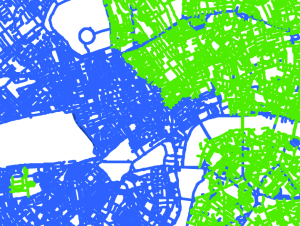
London’s Street Trees

Following a data release of Southwark’s publically maintained trees a couple of years back, the Greater London Authority recently published a map which shows street trees (trees along roads and public paths, and trees in public open spaces, such as small parks and other minor green areas). Each borough has its own tree database and […]

Continue reading »

London Boroughs Typographical Map

Typographical maps (maps made up of words representing each area, which form the map themselves) are a favourite of Mapping London and we featured a lovely example earlier this year. It is a lovely print but it had one problem – it only featured the central area of London. Lots of interesting places in Zone […]

Continue reading »

London’s Exodus

londonexodus

Time Out London, the venerable London free magazine, have spotted that everyone in London loves maps, and so have launched a regular London Mapped feature in their City Life section & blog. This week’s map is rather interesting and not one I’ve seen before. It shows ONS 2015 data on net migration between London’s boroughs […]

Continue reading »