Modern London Maps
Ever thought we should be a book? Well, Modern London Maps, while unrelated to Mapping London, is probably quite close to the book that we
Continue reading »The latest outputs from researchers, alumni and friends at the UCL Centre for Advanced Spatial Analysis (CASA).

Ever thought we should be a book? Well, Modern London Maps, while unrelated to Mapping London, is probably quite close to the book that we
Continue reading » Introduction
The Met Office, as the national meteorological service for the United Kingdom, provides valuable weather data through its API called DataPoint. This API caters to a wide range of users, including professionals, scien…
This delightful, colourful piece of cartography, is the first map by illustrator, limerick-creator and Walthamstow resident Angry Dan. The piece is a 60cm x 60cm
Continue reading »Artificial Intelligence is on everyone’s minds, and so is the human-induced environmental decline of our planet Earth. The Connected Environments team, as part of The Bartlett Centre for Advanced Spatial…
Continue reading »The FT published an article called “An Indian restaurant crawl along London’s Elizabeth Line” which came illustrated with this rather nice map that shows the
Continue reading »Dex, profilic creator of typographic maps of London , has published Animals of London, in partnership with the London Wildlife Trust (who receive 20% of the proceeds of sales of the prints). We have always liked typographic maps (ones where the text ma…
Continue reading »London-based artist and globemaker Julia Forte was featured in one of Mapping London’s earliest posts – way back in 2011 we featured the Map of London Peculiars. More recently the artist has combined maps and globes together – but rat…
Continue reading »London has a lot more rivers than just the River Thames and River Lea – but many of the rest are either very small and easily overlooked, or buried underground (culverted), typically by industrious Victorians looking to clean up channels that bec…
Continue reading »Adam Dant, artist, creates art which is often based around a geographical location, using cartography to frame a topic, often drawing out a key road or other structure into a simple geometric shape. This is particularly evident The Gilded Desert, which…
Continue reading »Quite a bit of creative activity is going on in the south-west London borough of Wandsworth, as this map & guide, produced late last year, illustrates well. Art hotspots are picked out subtly as numbers (with caption on the back) while illustration…
Continue reading »The FT has run a couple of articles [$] recently on housing in south-east London, and to accompany both of them, they commissioned freelance illustrator Laura Hallett to draw these illustrations of the area. We like the distinctive colour accents for t…
Continue reading »This stylised map of central London was created by MUTI, a South African design studio, and is “as seen in Mary Poppins Returns”. It was commissioned by High Life (the British Airways inflight magazine). It’s a nice bit of artistic ca…
Continue reading »The public may not be able to visit Tottenham Court Road station’s Crossrail concourse or platforms yet, thanks to the well-publicised delay across the wider project, but the station was one of the most complete in the central section, a year ago…
Continue reading »This artistic map of a green walking route in central London was drawn by graphic designer Helen Ilus. By showing just the parks that are the focus of the walk, and not the rest of London’s hustle and bustle, it is an effective and attractive way…
Continue reading »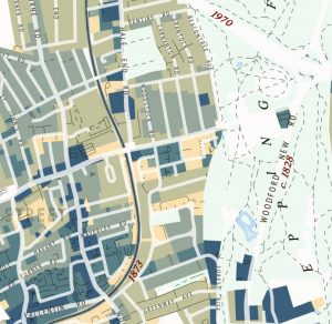
This attractive map of the housing and infrastructure history of Walthamstow and Leyton in north-east London has been created by Scott Davies. Scott used QGIS and OpenStreetMap data to create an attractive, vintage-style basemap and then shaded residential areas with different colours indicating when each block was developed. Older areas are shown in blues, while […]
Continue reading »The Little Globe Company is Loraine Rutt, a London-based cartographer and artist who specialises in maps created from clay, perhaps most famously crafting and hand-painting miniature porcelain globes in painstakingly precise detail. Her output is not just globe-based though, as this piece, showing London’s relief (hills and valleys) as well as its river network, both […]
Continue reading »This lovely map, hand-created by artist-cartographer Adam Dant, which was commissioned by the East End Trades Guild, is launched today at their Christmas takeover of Old Spitalfields Market – you’ll be able to pick up a free copy there. The map shows the locations of some of the more interesting traders and small businesses in […]
Continue reading »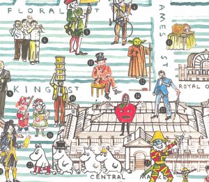
In celebration of the Christmas lights being switched on in Covent Garden this evening, we feature this lovely map of the precinct, which has been drawn by artist Adam Dant, for The Covent Gardener, a periodical that focuses on the landmarks, shops and residents and characters of London’s famous and bustling shopping and tourism heart, […]
Continue reading »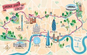
Urban Rambles is a new book by Nicholas Rudd-Jones, featuring walks through many of England’s cities. The book comes with a 22 route maps, drawn by illustrator Sara Mulvanny (see her portfolio page for the book), including a couple in London, which we feature here. Above is the “London Inner Circle” which stretches from Hyde […]
Continue reading »Adam Dant has, for a long time, been sketching lovely maps of London history, culture and phenomena, often focusing in particular on S the historic East End. Now, Batsford, an imprint of Pavilion Books, has produced this book, collating Dant’s existing wonderful maps (and debuting some new ones) in single place and adding background information. […]
Continue reading »What do you do when you are a boutique retailer, with two showrooms that are both small and are a ten minute walk away from each other, with some interesting but confusing streets in between? If you are in a rush you just screenshot a Google Maps route and stick it on your website, so […]
Continue reading »
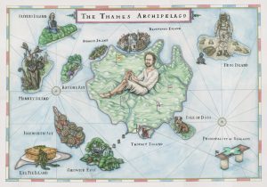
Mapping London has long enjoyed Stephen Walter’s fabulously detailed, painstakingly created pencil-sketch maps of London, and now one of his most famous works, The Island, has been made into a jigsaw puzzle. It was launched late last year by publishers Prestel UK and comes as a 500-piece work. The team at Mapping London Towers likes […]
Continue reading »The Chiswick Timeline, a mural of maps showing the history of the pleasant west London neighbourhood, was successfully crowdfunded and launched last month. It appears alongside a road as it passes underneath a railway bridge by Turnham Green station. A commemorative book, reproducing the work, is available to buy online or at Foster’s Bookshop on […]
Continue reading »This hand-sketched map has been produced by Adam Dant and Herb Lester, for the East End Trades Guild, to promote over 200 small businesses based in east and north-east London. Over a hundred of these are independent shops, cafes and restaurants to visit. The map is presented with an unusual projection, focusing on Columbia Road […]
Continue reading »
The Mayor of London released a draft version of his New London Plan this week. The plan is full of interesting maps, but one of the nicest looking ones is on the front cover. It’s an illustrative map created by, we believe, artist Jan Kallwejt (portfolio) which combines geographical landmarks, in their approximately correct relative […]
Continue reading »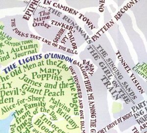
Jones & Sawers’ Map of Fictional London is an arty typographic map of central London, where the street and park names are replaced with the names of the novels, plays and other works that mention them. Over 600 such pieces are named on the map. The cartography is rather attractive, with pastel shades and the […]
Continue reading »Not all maps of London need to cover the whole, 33 borough, 8 million-population metropolis. Here’s three maps that focus more on a local area: 1. Tottenham This attractive little map promotes a number of the new start-up businesses in the area – including a climbing wall, a brewery/bar, and arts centre and a concept […]
Continue reading »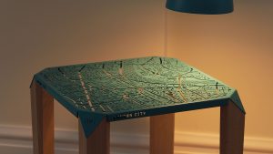
Map on Table is a project, currently being crowdfunded on Kickstarter by Hasan Agar, to careful cut out an ornate metallic map of central London, apply a colour finish and mount it on four legs to create a small table. The table corners have markers showing the cardinal directions on them. A rendering of Agar’s […]
Continue reading »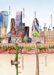
We featured Bridges of London earlier this week. However, the public realm relating to the Thames is more than the river itself and the bridges crossing it. One of London’s defining features, in recent times, as the Thames has cleaned and the spaces beside it have become less-traffic choked, is its riverside frontage. This lovely […]
Continue reading »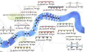
The River Thames is London’s defining geographical feature and its inclusion is almost mandatory on any map attempting to cover the whole of the capital. Bridges are most Londoners’ visible contact with the river, with over 30 spanning the river in London, including elevated crossing by the so-called “Underground”. As such, illustrated maps of the […]
Continue reading »This map created by illustrator Mike Hall (who we’ve featured before) for Penguin Books, shows the locations in London that featured in John le Carré’s George Smiley spy novels. This is a lovely map, drawn from scratch and using a distinctive yellow/green and pastel blue pastel colour palette that evokes classic literary works and hand-printed […]
Continue reading »This artistic map of central London attractions was drawn by illustrator Andy Smith for Chiltern Railway, as part of a promotion to attract families into London during the summer holidays. We like the bold and unusual colour scheme for the map, of maroons, pinks and oranges. It’s fairly unusual to see the Thames in pink […]
Continue reading »It’s a typical August day in London today, with the rain falling pretty heavily and at least one tube station closed due to flooding. London’s greatest long-term flooding threat, though, is from isothermal expansion of the world’s water (i.e. it needs slightly more space as it heats) due to climate change. The above map was […]
Continue reading »
We’ve long been fans of artist Stephen Walter’s monochromatic cartographical style and have featured numerous map-based artworks by him over the years. It’s been interesting seeing his style subtly evolve, from intense and slightly angry detections of “seas” of houses and caustic comments, to the slightly more restrained, but still very distinctive, style of his […]
Continue reading »
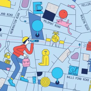
This is one of seven London neighborhood maps, each drawn by different artists from the University of the Arts London and recently released by the Walk with Me project. This map, of Dalston and Stoke Newington in north-east London, was drawn by Martina Paukova. We like the distinctive shade of blue used for the map […]
Continue reading »
The Great British Colouring Map taps into a sudden enthusiasm for adult colouring-in books, by taking Ordnance Survey maps of many classic British places, stripping out all the colour, shading and labels, and inviting the reader to use their colouring pencils to shade and tone it as they please. The book, published by Laurence King […]
Continue reading »
Curiocity is a weighty tome, written by Henry Eliot and Matt Lloyd-Rose and published recently by Particular Books. The book follows on from a short, alphabetically organised series of pocket maps, some of which that we featured (C) a few years ago (D). This is a book which certainly delivers on its back-cover promise to […]
Continue reading »
Typographical maps (maps made up of words representing each area, which form the map themselves) are a favourite of Mapping London and we featured a lovely example earlier this year. It is a lovely print but it had one problem – it only featured the central area of London. Lots of interesting places in Zone […]
Continue reading »
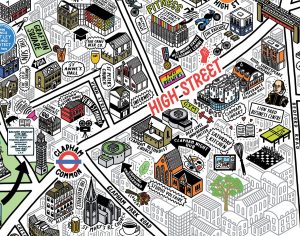
Here’s a great new mural that’s has just been unveiled in Clapham, where it appears on the side of a wall. The Clapham Cultural Map was drawn by Jenni Sparks (we featured her map of London a few years ago and was commissioned by This is Clapham, the Business Improvement District corporation for the area. […]
Continue reading »
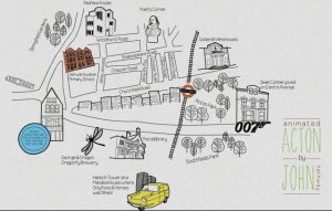
Here’s a nice hand-drawn map created by graphic designer John Hathaway, of his neighborhood, Acton in west London, along with some local landmarks. We like the good, crisp cartography and the detail, particularly the individual trees and the Robin Reliant! Event better, here’s a speeded-up video of the creation of the map itself: Sent by […]
Continue reading »