A Chronological Map of Walthamstow

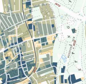
This attractive map of the housing and infrastructure history of Walthamstow and Leyton in north-east London has been created by Scott Davies. Scott used QGIS and OpenStreetMap data to create an attractive, vintage-style basemap and then shaded residential areas with different colours indicating when each block was developed. Older areas are shown in blues, while […]

Continue reading »

Dwelling Ages

The Valuation Office Agency publish some interesting open data sets from time-to-time. One that caught my eye recently was a breakdown of counts of residential buildings in each small area (LSOA, around 700 houses) by the decade that they were built in. The data is not perfect for mapping – pre-1900 is grouped together into […]

Continue reading »

The Age of Buildings

We don’t have open individual building age data in the UK, unlike in some other countries (the data has been used to great effect in New York City and Amsterdam) but the Valuation Office Agency, which amongst other things decides council tax bandings for residential properties in England and Wales, has published some interesting data … Continue reading The Age of Buildings

Continue reading »