Applications of Agent-based Models

Often I get asked the question along the lines of: “how are agent-based models are being used outside academia, especially in government and private industry?” So I thought it was about time I briefly write something about this.

Let me start with a question I ask my students when I first introduce agent-based modeling: “Have you ever seen an agent-based model before?” Often the answer is NO, but then I show them the following clip from MASSIVE (Multiple Agent Simulation System in Virtual Environment) where agent-based models are used in a variety of movies and TV shows. But apart from TV shows and movies where else have agent-based models been used?
There are two specific application domains where agent-based modeling has taken off. The first being pedestrian simulation for example, LegionSteps and EXODUS simulation platforms. The second is the area of traffic modeling for example, there are several microsimulation/agent-based model platforms such as PTV Visum, TransModeler and Paramics. Based on these companies websites they have clients in industry, government and academia.
If we move away from the areas discussed above, there is a lot of writing about the potential of agent-based modeling. For example, the Bank of England had a article entitled “Agent-based models: understanding the economy from the bottom up” which to quote from the summary:

“considers the strengths of agent-based modelling, which explains the behaviour of a system by simulating the behaviour of each individual ‘agent’ in it, and the ways that it can be used to help central banks understand the economy.”

Similar articles can be seen in the New York Times and the Guardian to name but a few. But where else have agent-based models been used? A sample (and definitely not an exhaustive list) of applications and references are provided below for interested readers:
  • Southwest Airlines used an agent-based model to improve how it handled cargo (Seibel and Thomas, 2000).
  • Eli Lilly used an agent-based model for drug development (Bonabeau, 2003a).
  • Pacific Gas and Electric: Used an agent based model to see how energy flows through the power grid (Bonabeau, 2003a).
  • Procter and Gamble used an agent-based model to understand its consumer markets (North et al., 2010) while Hewlett-Packard used an agent-based model to understand how hiring strategies effect corporate culture (Bonabeau, 2003b).
  • Macy’s have used agent-based models for store design (Bonabeau, 2003b).
  • NASDAQ used and agent based model to explore changes to Stock Market’s decimalization (Bonabeau, 2003b; Darley and Outkin, 2007).
  • Using a agent-based model to explore capacity and demand in theme parks (Bonabeau, 2000).
  • Traffic and pedestrian modeling (Helbing and Balietti, 2011).
  • Disease dynamics (e.g. Eubank et al., 2004).
  • Agent-based modeling has also been used for wild fire training, incident command and community outreach (Guerin and Carrera, 2010). For example SimTable was used in the  2016 Sand Fire in California. 
  • InSTREAM: Explores how river salmon populations react to changes (Railsback and Harvey, 2002).

While not a comprehensive list, it is hoped that these examples and links will be useful if someone asks the question I started this post with. If anyone else knows of any other real world applications of agent-based modeling please let me know (preferably with a link to a paper or website).
 
References

  • Bonabeau, E. (2000), ‘Business Applications of Social Agent-Based Simulation’, Advances in Complex Systems, 3(1-4): 451-461.
  • Bonabeau, E. (2003a), ‘Don’t Trust Your Gut’, Harvard Business Review, 81(5): 116-123.
  • Bonabeau, E. (2003b), ‘Predicting the Unpredictable’, Harvard Business Review, 80(3): 109-116.
  • Darley, V. and Outkin, A.V. (2007), NASDAQ Market Simulation: Insights on a Major Market from the Science of Complex Adaptive Systems, World Scientific Publishing, River Edge, NJ.
  • Eubank, S., Guclu, H., Kumar, A.V.S., Marathe, M.V., Srinivasan, A., Toroczkai, Z. and Wang, N. (2004), ‘Modelling Disease Outbreaks in Realistic Urban Social Networks’, Nature, 429: 180-184.
  • Guerin, S. and Carrera, F. (2010), ‘Sand on Fire: An Interactive Tangible 3D Platform for the Modeling and Management of Wildfires.’ WIT Transactions on Ecology and the Environment, 137: 57-68.
  • Helbing, D. and Balietti, S. (2011), How to do Agent-based Simulations in the Future: From Modeling Social Mechanisms to Emergent Phenomena and Interactive Systems Design, Santa Fe Institute, Working Paper 11-06-024, Santa Fe, NM.
  • North, M.J., Macal, C.M., Aubin, J.S., Thimmapuram, P., Bragen, M., Hahn, J., J., K., Brigham, N., Lacy, M.E. and Hampton, D. (2010), ‘Multiscale Agent-based Consumer Market Modeling’, Complexity, 15(5): 37-47.
  • Railsback, S.F. and Harvey, B.C. (2002), ‘Analysis of Habitat Selection Rules using an Individual-based Model’, Ecology, 83(7): 1817-1830.
  • Seibel, F. and Thomas, C. (2000), ‘Manifest Destiny: Adaptive Cargo Routing at Southwest Airlines’, Perspectives on Business Innovation, 4: 27-33.

    Continue reading »

    Applications of Agent-based Models

    Often I get asked the question along the lines of: “how are agent-based models are being used outside academia, especially in government and private industry?” So I thought it was about time I briefly write something about this.

    Let me start with a question I ask my students when I first introduce agent-based modeling: “Have you ever seen an agent-based model before?” Often the answer is NO, but then I show them the following clip from MASSIVE (Multiple Agent Simulation System in Virtual Environment) where agent-based models are used in a variety of movies and TV shows. But apart from TV shows and movies where else have agent-based models been used?
    There are two specific application domains where agent-based modeling has taken off. The first being pedestrian simulation for example, LegionSteps and EXODUS simulation platforms. The second is the area of traffic modeling for example, there are several microsimulation/agent-based model platforms such as PTV Visum, TransModeler and Paramics. Based on these companies websites they have clients in industry, government and academia.
    If we move away from the areas discussed above, there is a lot of writing about the potential of agent-based modeling. For example, the Bank of England had a article entitled “Agent-based models: understanding the economy from the bottom up” which to quote from the summary:

    “considers the strengths of agent-based modelling, which explains the behaviour of a system by simulating the behaviour of each individual ‘agent’ in it, and the ways that it can be used to help central banks understand the economy.”

    Similar articles can be seen in the New York Times and the Guardian to name but a few. But where else have agent-based models been used? A sample (and definitely not an exhaustive list) of applications and references are provided below for interested readers:
    • Southwest Airlines used an agent-based model to improve how it handled cargo (Seibel and Thomas, 2000).
    • Eli Lilly used an agent-based model for drug development (Bonabeau, 2003a).
    • Pacific Gas and Electric: Used an agent based model to see how energy flows through the power grid (Bonabeau, 2003a).
    • Procter and Gamble used an agent-based model to understand its consumer markets (North et al., 2010) while Hewlett-Packard used an agent-based model to understand how hiring strategies effect corporate culture (Bonabeau, 2003b).
    • Macy’s have used agent-based models for store design (Bonabeau, 2003b).
    • NASDAQ used and agent based model to explore changes to Stock Market’s decimalization (Bonabeau, 2003b; Darley and Outkin, 2007).
    • Using a agent-based model to explore capacity and demand in theme parks (Bonabeau, 2000).
    • Traffic and pedestrian modeling (Helbing and Balietti, 2011).
    • Disease dynamics (e.g. Eubank et al., 2004).
    • Agent-based modeling has also been used for wild fire training, incident command and community outreach (Guerin and Carrera, 2010). For example SimTable was used in the  2016 Sand Fire in California. 
    • InSTREAM: Explores how river salmon populations react to changes (Railsback and Harvey, 2002).

    While not a comprehensive list, it is hoped that these examples and links will be useful if someone asks the question I started this post with. If anyone else knows of any other real world applications of agent-based modeling please let me know (preferably with a link to a paper or website).
     
    References

    • Bonabeau, E. (2000), ‘Business Applications of Social Agent-Based Simulation’, Advances in Complex Systems, 3(1-4): 451-461.
    • Bonabeau, E. (2003a), ‘Don’t Trust Your Gut’, Harvard Business Review, 81(5): 116-123.
    • Bonabeau, E. (2003b), ‘Predicting the Unpredictable’, Harvard Business Review, 80(3): 109-116.
    • Darley, V. and Outkin, A.V. (2007), NASDAQ Market Simulation: Insights on a Major Market from the Science of Complex Adaptive Systems, World Scientific Publishing, River Edge, NJ.
    • Eubank, S., Guclu, H., Kumar, A.V.S., Marathe, M.V., Srinivasan, A., Toroczkai, Z. and Wang, N. (2004), ‘Modelling Disease Outbreaks in Realistic Urban Social Networks’, Nature, 429: 180-184.
    • Guerin, S. and Carrera, F. (2010), ‘Sand on Fire: An Interactive Tangible 3D Platform for the Modeling and Management of Wildfires.’ WIT Transactions on Ecology and the Environment, 137: 57-68.
    • Helbing, D. and Balietti, S. (2011), How to do Agent-based Simulations in the Future: From Modeling Social Mechanisms to Emergent Phenomena and Interactive Systems Design, Santa Fe Institute, Working Paper 11-06-024, Santa Fe, NM.
    • North, M.J., Macal, C.M., Aubin, J.S., Thimmapuram, P., Bragen, M., Hahn, J., J., K., Brigham, N., Lacy, M.E. and Hampton, D. (2010), ‘Multiscale Agent-based Consumer Market Modeling’, Complexity, 15(5): 37-47.
    • Railsback, S.F. and Harvey, B.C. (2002), ‘Analysis of Habitat Selection Rules using an Individual-based Model’, Ecology, 83(7): 1817-1830.
    • Seibel, F. and Thomas, C. (2000), ‘Manifest Destiny: Adaptive Cargo Routing at Southwest Airlines’, Perspectives on Business Innovation, 4: 27-33.

      Continue reading »

      Modeling the Emergence of Riots: A Geosimulation Approach

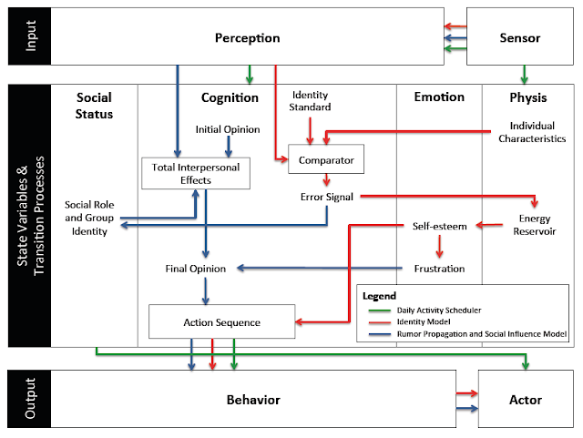
      As you might of guessed the paper is about riots but that is not all. In the paper we have a highly detailed cognitive model implemented through the PECS (Physical conditions, Emotional state, Cognitive capabilities, and Social status) framework based around identity theory. The purpose of the model (and paper) is to explore how the unique socioeconomic variables underlying Kibera, a slum in Nairobi, coupled with local interactions of its residents, and the spread of a rumor, may trigger a riot such as those seen in 2007. 
      In order to explore this question from the “bottom up” we have developed a novel agent-based model that integrates social network analysis (SNA) and geographic information systems (GIS) for this purpose. In the paper we argue that this integration facilitates the modeling of dynamic social networks created through the agents’ daily interactions. The GIS is used to develop a realistic environment for agents to move and interact that includes a road network and points of interest which impact their daily lives.
      Below is the abstract and a summary of its highlights in order to give you a sense of what our research contribution is. In addition to this we also provide some images either from the paper itself or the from Overview, Design Concepts, and Details (ODD) protocol. Finally at the bottom of this post you can see one of the simulation runs, details of where the model can be downloaded along with the full citation.

      Paper Abstract:

      Immediately after the 2007 Kenyan election results were announced, the country erupted in protest. Riots were particularly severe in Kibera, an informal settlement located within the nations capital, Nairobi. Through the lens of geosimulation, an agent-based model is integrated with social network analysis and geographic information systems to explore how the environment and local interactions underlying Kibera, combined with an external trigger, such as a rumor, led to the emergence of riots. We ground our model on empirical data of Kibera’s geospatial landscape, heterogeneous population, and daily activities of its residents. In order to effectively construct a model of riots, however, we must have an understanding of human behavior, especially that related to an individual’s need for identity and the role rumors play on a person’s decision to riot. This provided the foundation to develop the agents’ cognitive model, which created a feedback system between the agents’ activities in physical space and interactions in social space. Results showed that youth are more susceptible to rioting. Systematically increasing education and employment opportunities, however, did not have simple linear effects on rioting, or even on quality of life with respect to income and activities. The situation is more complex. By linking agent-based modeling, social network analysis, and geographic information systems we were able to develop a cognitive framework for the agents, better represent human behavior by modeling the interactions that occur over both physical and social space, and capture the nonlinear, reinforcing nature of the emergence and dissolution of riots.

      Keywords: agent-based modeling; geographic information systems; social network analysis; riots; social influence; rumor propagation.

      Paper Highlights:

      • An agent-based model integrates geographic information systems and social network analysis to model the emergence of riots. 
      • The physical environment and agent attributes are developed using empirical data, including GIS and socioeconomic data. 
      • The agent’s cognitive framework allowed for modeling their activities in physical space and interactions in social space. 
      • Through the integration of the three techniques, we were able to capture the complex, nonlinear nature of riots. 
      • Results show that youth are most vulnerable, and, increasing education and employment has nonlinear affects on rioting.
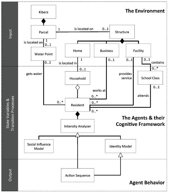
      The high-level UML diagram of the model
      A high-level representation of the model’s agent behavior incorporated into the PECS framework

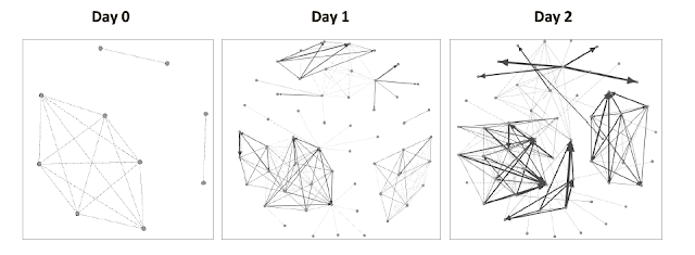
      An example of the evolution of social networks of ten Residents across the first two days of a simulation run.

      The movie below shows the agent-based model which explores ethnic clashes in the Kenyan slum. The environment is made up of households, businesses, and service facilities (such data comes from OpenStreetMap). Agents within the model use a transportation network to move across the environment. As agents go about their daily activities, they interact with other agents – building out an evolving social network. Agents seek to meet their identity standard. Failure to reach their identity standard increases the agents frustration which can lead to an aggressive response (i.e. moving from blue to red color) such as rioting.

      As with many of our models, we provide the data, model code and detailed model description in the form of the ODD protocol for others to use, learn more or to extend. Click here for more information.

      Full Reference:

      Pires, B. and Crooks, A.T. (2017), Modeling the Emergence of Riots: A Geosimulation Approach, Computers, Environment and Urban Systems, 61: 66-80. (pdf)

      As normal, any thoughts or comments are most appreciated.
       

      Continue reading »

      Modeling the Emergence of Riots: A Geosimulation Approach

      As you might of guessed the paper is about riots but that is not all. In the paper we have a highly detailed cognitive model implemented through the PECS (Physical conditions, Emotional state, Cognitive capabilities, and Social status) framework based around identity theory. The purpose of the model (and paper) is to explore how the unique socioeconomic variables underlying Kibera, a slum in Nairobi, coupled with local interactions of its residents, and the spread of a rumor, may trigger a riot such as those seen in 2007. 
      In order to explore this question from the “bottom up” we have developed a novel agent-based model that integrates social network analysis (SNA) and geographic information systems (GIS) for this purpose. In the paper we argue that this integration facilitates the modeling of dynamic social networks created through the agents’ daily interactions. The GIS is used to develop a realistic environment for agents to move and interact that includes a road network and points of interest which impact their daily lives.
      Below is the abstract and a summary of its highlights in order to give you a sense of what our research contribution is. In addition to this we also provide some images either from the paper itself or the from Overview, Design Concepts, and Details (ODD) protocol. Finally at the bottom of this post you can see one of the simulation runs, details of where the model can be downloaded along with the full citation.

      Paper Abstract:

      Immediately after the 2007 Kenyan election results were announced, the country erupted in protest. Riots were particularly severe in Kibera, an informal settlement located within the nations capital, Nairobi. Through the lens of geosimulation, an agent-based model is integrated with social network analysis and geographic information systems to explore how the environment and local interactions underlying Kibera, combined with an external trigger, such as a rumor, led to the emergence of riots. We ground our model on empirical data of Kibera’s geospatial landscape, heterogeneous population, and daily activities of its residents. In order to effectively construct a model of riots, however, we must have an understanding of human behavior, especially that related to an individual’s need for identity and the role rumors play on a person’s decision to riot. This provided the foundation to develop the agents’ cognitive model, which created a feedback system between the agents’ activities in physical space and interactions in social space. Results showed that youth are more susceptible to rioting. Systematically increasing education and employment opportunities, however, did not have simple linear effects on rioting, or even on quality of life with respect to income and activities. The situation is more complex. By linking agent-based modeling, social network analysis, and geographic information systems we were able to develop a cognitive framework for the agents, better represent human behavior by modeling the interactions that occur over both physical and social space, and capture the nonlinear, reinforcing nature of the emergence and dissolution of riots.

      Keywords: agent-based modeling; geographic information systems; social network analysis; riots; social influence; rumor propagation.

      Paper Highlights:

      • An agent-based model integrates geographic information systems and social network analysis to model the emergence of riots. 
      • The physical environment and agent attributes are developed using empirical data, including GIS and socioeconomic data. 
      • The agent’s cognitive framework allowed for modeling their activities in physical space and interactions in social space. 
      • Through the integration of the three techniques, we were able to capture the complex, nonlinear nature of riots. 
      • Results show that youth are most vulnerable, and, increasing education and employment has nonlinear affects on rioting.

      The high-level UML diagram of the model
      A high-level representation of the model’s agent behavior incorporated into the PECS framework

      An example of the evolution of social networks of ten Residents across the first two days of a simulation run.

      The movie below shows the agent-based model which explores ethnic clashes in the Kenyan slum. The environment is made up of households, businesses, and service facilities (such data comes from OpenStreetMap). Agents within the model use a transportation network to move across the environment. As agents go about their daily activities, they interact with other agents – building out an evolving social network. Agents seek to meet their identity standard. Failure to reach their identity standard increases the agents frustration which can lead to an aggressive response (i.e. moving from blue to red color) such as rioting.

      As with many of our models, we provide the data, model code and detailed model description in the form of the ODD protocol for others to use, learn more or to extend. Click here for more information.

      Full Reference:

      Pires, B. and Crooks, A.T. (2017), Modeling the Emergence of Riots: A Geosimulation Approach, Computers, Environment and Urban Systems, 61: 66-80. (pdf)

      As normal, any thoughts or comments are most appreciated.
       

      Continue reading »

      New Publication: GIS and Agent-Based models for Humanitarian Assistance

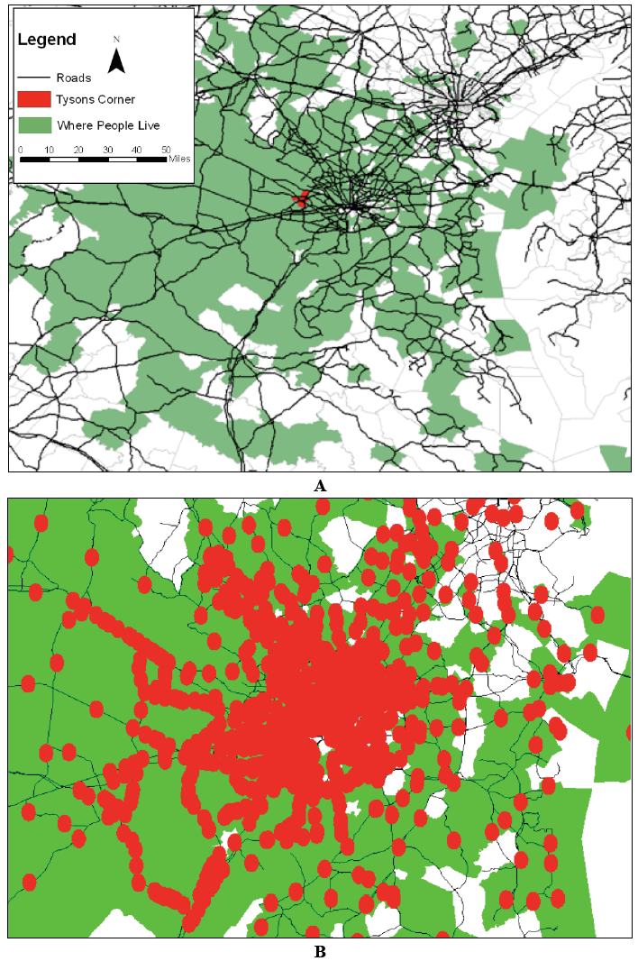
      Inputs to the model
       
      As the readers of the blog know, we have an interest in GIS, agent-based modeling and crowdsourcing. Now we have a paper that combines all these three elements. Its entitled “GIS and Agent-Based models for Humanitarian Assistance” and is published in Computers, Environment and Urban Systems. 
       
      The model itself was written in MASON and uses extensively GeoMASON. Data comes from several different sources (both raster and vector) including OpenStreetMap and LandScan. Below you can read an abstract of the paper and see a movie of one of the scenarios.

      “Natural disasters such as earthquakes and tsunamis occur all over the world, altering the physical landscape and often severely disrupting people’s daily lives. Recently researchers’ attention has focused on using crowds of volunteers to help map the damaged infrastructure and devastation caused by natural disasters, such as those in Haiti and Pakistan. This data is extremely useful, as it is allows us to assess damage and thus aid the distribution of relief, but it tells us little about how the people in such areas will react to the devastation. This paper demonstrates a prototype spatially explicit agent-based model, created using crowdsourced geographic information and other sources of publicly available data, which can be used to study the aftermath of a catastrophic event. The specific case modelled here is the Haiti earthquake of January 2010. Crowdsourced data is used to build the initial populations of people affected by the event, to construct their environment, and to set their needs based on the damage to buildings. We explore how people react to the distribution of aid, as well as how rumours relating to aid availability propagate through the population. Such a model could potentially provide a link between socio-cultural information about the people affected and the relevant humanitarian relief organizations.”

      Full Reference: 

      Crooks, A.T. and Wise, S. (2013), GIS and Agent-Based models for Humanitarian Assistance, Computers, Environment and Urban Systems, 41: 100-111.

      Continue reading »

      New Publication: GIS and Agent-Based models for Humanitarian Assistance

      Inputs to the model
       
      As the readers of the blog know, we have an interest in GIS, agent-based modeling and crowdsourcing. Now we have a paper that combines all these three elements. Its entitled “GIS and Agent-Based models for Humanitarian Assistance” and is published in Computers, Environment and Urban Systems. 
       
      The model itself was written in MASON and uses extensively GeoMASON. Data comes from several different sources (both raster and vector) including OpenStreetMap and LandScan. Below you can read an abstract of the paper and see a movie of one of the scenarios.

      “Natural disasters such as earthquakes and tsunamis occur all over the world, altering the physical landscape and often severely disrupting people’s daily lives. Recently researchers’ attention has focused on using crowds of volunteers to help map the damaged infrastructure and devastation caused by natural disasters, such as those in Haiti and Pakistan. This data is extremely useful, as it is allows us to assess damage and thus aid the distribution of relief, but it tells us little about how the people in such areas will react to the devastation. This paper demonstrates a prototype spatially explicit agent-based model, created using crowdsourced geographic information and other sources of publicly available data, which can be used to study the aftermath of a catastrophic event. The specific case modelled here is the Haiti earthquake of January 2010. Crowdsourced data is used to build the initial populations of people affected by the event, to construct their environment, and to set their needs based on the damage to buildings. We explore how people react to the distribution of aid, as well as how rumours relating to aid availability propagate through the population. Such a model could potentially provide a link between socio-cultural information about the people affected and the relevant humanitarian relief organizations.”

      Full Reference: 

      Crooks, A.T. and Wise, S. (2013), GIS and Agent-Based models for Humanitarian Assistance, Computers, Environment and Urban Systems, 41: 100-111.

      Continue reading »
      1 2 3