London Suburban Lines 1939 (Modern Reproduction)

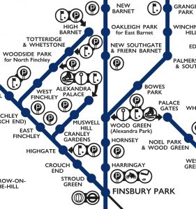
This lovely schematic diagram was first created in 1939 by George Dow. It shows the three LNER (London and North Eastern Railway) north London networks – radiating out from the Marylebone, King’s Cross, and Liverpool Street/Fenchurch Street London terminii, in a single map. Unusually, the map includes a series of pictograms, illustrating nearby facilities, leisure […]

Continue reading »

O/D Map of London Commuting

This map shows the cross-borough London commuting flows in a different way to the conventional approach of drawing lines between the start and end of each commute (as shown here. It’s a large map of London boroughs, which each borough itself containing a small map of London. The intensity of the colour in each of […]

Continue reading »

Crossrail Station Footprints

We’ve featured Crossrail’s official construction map before, when it was showing the progress of the various TBMs (tunnel boring machines) drilling through London, but with the tunnels themselves now burrowed, it’s received a welcome update – if you zoom right in, you can now see the shape and extent of the underground stations. And they […]

Continue reading »