Mapping London: Inspiration from 4 Map Enthusiasts
You’ve read the blog, maybe you’ve read the book, now come and hear from the creators. A very special evening of talks will take place
Continue reading »The latest outputs from researchers, alumni and friends at the UCL Centre for Advanced Spatial Analysis (CASA).

You’ve read the blog, maybe you’ve read the book, now come and hear from the creators. A very special evening of talks will take place
Continue reading »Ever thought we should be a book? Well, Modern London Maps, while unrelated to Mapping London, is probably quite close to the book that we
Continue reading »The Map House, a wonderful gallery in Knightsbridge in central London which is itself over 100 years old, has just launched a month-long exhibition specifically
Continue reading »Kew is one of London’s leafy surburban neighbourhoods. Situated on a long curve of the River Thames, ot is of course famous for Kew Gardens,
Continue reading »The new map is the latest in a long line in attractively packaged, specialist maps from Blue Crow Media which highlight the locations of a single feature of London on a bepoke basemap and guide – be it notable trees, Brutalist buildings or in thi…
Continue reading »London-based artist and globemaker Julia Forte was featured in one of Mapping London’s earliest posts – way back in 2011 we featured the Map of London Peculiars. More recently the artist has combined maps and globes together – but rat…
Continue reading »London’s railway terminus stations are major landmarks in the inner city – they form a ring around the city’s core are used by many, these days, not just to catch a train, but to meet, shop and walk through. A new book, “London&…
Continue reading »From the desk of Blue Crow Media (we’ve featured several of their maps before) comes this new map of London, focusing on Postmodernism in the capital. What do they mean by postmodern? Basically, buildings with a distinctive architecture style fol…
Continue reading »We’ve all had plenty of to explore our local areas, over the last year, with several lockdowns and other movement restrictions meaning that our local village, town or part of London is our exercise arena. With this in mind it’s always nice …
Continue reading »London has a long and gruesome history – indeed part of its tourist industry is focused on tours and attractions based on the “Jack the Ripper” cases, so there was always going to be plenty of London-related content in this new book w…
Continue reading »“Bloody London” is a new book by author, illustrator cartographer David Fathers. Previously writing about the Thames Path in London, the Regents’ Canal and London’s “lost rivers“, David has for this book focused on a…
Continue reading »Perhaps the world’s most famous historical geodemographic maps, the London Poverty Maps were created by Charles Booth over the course of a decade in the late 19th century, exhaustively colouring each individual house in the capital, on the basis …
Continue reading »The A to Z is a bit of an institution when it comes to London maps. It, along with the Tube Map, is probably the most famous and well known London map, and certainly the most famous atlas. We’ve reviewed a historic A-Z map of London before, but n…
Continue reading »Drawn in a similar era to the historic map of Kew, here is another map from the archives of Transport for London at the Transport Museum, which show the green and bucolic land that now forms London’s suburbs, in the early 1900s – i.e. after…
Continue reading »This decorative map, simply called “Kew”, was produced by Herry Perry of Vincent Brooks lithographers in 1929. It was part of a series of posters commissioned for what is now Transport for London and actually depicts the area to the south o…
Continue reading »This map, dating from 1875, appears on the back of a “Guinea season ticket” for entry to Alexandra Palace, in north London. The palace was recently restored and public entrance is now available to some areas for free. It’s a nice, vin…
Continue reading »The Painted Hall at the Old Royal Naval College in Greenwich reopens this weekend after a two-year renovation and restoration. At the entrance to the new visitor centre in the old undercroft underneath the hall, sits this backlit copy of a historic map…
Continue reading »The John Snow Cholera Map is world famous as the map that identified the cause of the disease, and was one of the first epidemiological maps created. However, a number of other maps of the location of individuals with the disease were produced at aroun…
Continue reading »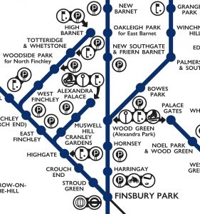
This lovely schematic diagram was first created in 1939 by George Dow. It shows the three LNER (London and North Eastern Railway) north London networks – radiating out from the Marylebone, King’s Cross, and Liverpool Street/Fenchurch Street London terminii, in a single map. Unusually, the map includes a series of pictograms, illustrating nearby facilities, leisure […]
Continue reading »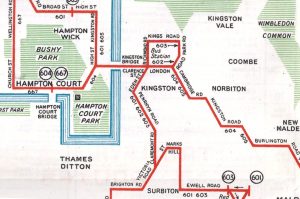
Readers of Mapping London, and Londoners in general, will be very familiar with the striking straight lines of the Tube Map. But you probably won’t have seen this map before, which employs the same kind of schematisation to show London’s now completely vanished tram and trolleybus network (there is a tram in south London now, […]
Continue reading »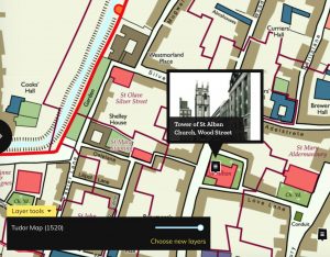
Layers of London, which has just launched, aims to be a platform for geolocating and documenting the local history of the capital. It works by allowing historical facts, comments and memories to be attached to pins on a map. The pins are grouped together as projects, or collections. The map itself can be adjusted, from […]
Continue reading »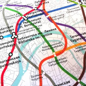
A lot of Londoners are currently focused on the World Cup in Russia at the moment, so Mapping London is taking a look eastwards, thanks to the latest boutique map created by productive cartographers Blue Crow Media. The map is essentially a Moscow version of their London Underground Architecture & Design Map and features the […]
Continue reading »Adam Dant has, for a long time, been sketching lovely maps of London history, culture and phenomena, often focusing in particular on S the historic East End. Now, Batsford, an imprint of Pavilion Books, has produced this book, collating Dant’s existing wonderful maps (and debuting some new ones) in single place and adding background information. […]
Continue reading »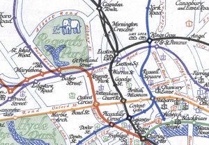
The Tube Map is a design classic – the straight lines, even spacing and lack of unnecessary above-ground detail has become a hall-mark of metro maps across the world, since it was first drawn by H.C. Beck in the 1930s. Today, the printed versions of London’s tube map include a specific acknowledgement of the creator […]
Continue reading »The Chiswick Timeline, a mural of maps showing the history of the pleasant west London neighbourhood, was successfully crowdfunded and launched last month. It appears alongside a road as it passes underneath a railway bridge by Turnham Green station. A commemorative book, reproducing the work, is available to buy online or at Foster’s Bookshop on […]
Continue reading »The Children’s Map of London (sometimes called the Children’s Pictorial Map of London) was first published by Bartholomew in 1938, the edition here is a minor update in 1955. All royalties from the sale of the map went to the Hospital for Sick Children in Great Ormond Street (aka GOSH) which appropriately does itself appear […]
Continue reading »Songs of London Town replaces street names with song names. The pastel coloured, hand-drawn basemap is overlaid with hundreds of song titles, each arranged over the street that it references. It’s rather a clever idea and allows for the creation of your own song-narrated self-guided tour of each central London neighborhood you happen to be […]
Continue reading »This animation of estimated global population density between 1970-2000 uses data produced by NASA’s SEDAC. For more information see here.
Continue reading »
The Corporate Archives division of Transport for London recently held a short internal exhibition at their headquarters at Palestra, called “Mapping London” and showcasing new and old maps of London’s transport from the archive. Amongst the highlights included this Lego historic tube map. The Lego is modern but the map was one of the last […]
Continue reading »
We normally feature “modern” maps on Mapping London, however this map despite being also known as the Map of Early Modern London, is certainly not new. It was first printed from wood blocks in 1561, the extracts here are from a 1633 edition which has been digitised at a very high resolution as part of […]
Continue reading »
From British Gas comes this lovely map of a walking trail in central London, that highlights many of the streets and locations that are still lit by gas lamps in London – it may come as a surprise to many people, but there are many gas lamps still in the oldest parts of London, lit […]
Continue reading »
Welcome to the Mapping London Christmas List 2016! Not long now until Christmas Day – if you are having a last minute present crisis, our list includes direct links, so you can browse, order, sit back and relax in the knowledge that the present selections for your London map geek friends (or yourself!) are all […]
Continue reading »
London has a great collection of grand buildings, famous bridges and other urban objects that delight tourists and residents alike, but there’s quite a few impressive structures that haven’t made it to 2016. Here is a map of a London that you can’t see. The premise is simple – it shows some of London’s distinctive […]
Continue reading »
Following on from their Brutalist London Map, Blue Crow Media have moved back a few decades and produced this new map of Art Deco London. The map is presented in an attractive slip and folds out to A2. It’s printed on silver paper, which gives the roads and rivers a lovely, sparkly sheen to them. […]
Continue reading »
As an update to our previous feature on a replica map set of the John Rocque eighteenth century map of London, we feature the Locating London’s Past project. At the heart of the website is a high-resolution scanned version of the aforementioned historic map, allowing anyone to see this 260 270-year-old snapshot of (central) London […]
Continue reading »
Here’s an attractive map commissioned by The Watch Gallery to highlight some of the key places in London, in the development of timekeeping. From the Old Observatory at Greenwich, to Big Ben, there are many horologically significant places featured here, including some recent location such as the Swiss clock installed in Borough Market to commemorate […]
Continue reading »
The latest pocket guide and fold-out map from boutique urban cartographers Herb Lester is “Punk London“, celebrating 40 years since the punk movement of the 1970s, by mapping key locations in central London where it happened. Mike Haddad is the carrtographer/designer. As with all Herb Lester maps it’s a proper, custom made and litho-printed map, […]
Continue reading »
To celebrate one year since the release of London: The Information Capital by Mapping London co-editor James Cheshire and graphic designer Oliver Uberti, and the book recently winning the BCS Award, the authors have released a number of new excepts from the book. Here we feature “What Lies Beneath”, a map of the tunnelled sections […]
Continue reading »
For fans all all things concrete comes this map of London’s most famous Brutalist buildings. Created by Blue Crow Media (see also their craft beer and cycling maps, it is the first in a new series of map-based guides to London architecture, focusing on the modern 1950s/60s “raw” concrete-heavy designs by Le Corbusier and others […]
Continue reading »
Today, the London Transport Museum unveils a new permanent gallery in its space in Covent Garden, called “London by Design“. The gallery includes a number of maps which have not been exhibited before, including this lovely map of the “Baker Street & Waterloo Railway (of which the Bakerloo Line‘s name is a portmanteau) which first […]
Continue reading »