Indian Restaurants on the Elizabeth Line
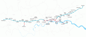
The FT published an article called “An Indian restaurant crawl along London’s Elizabeth Line” which came illustrated with this rather nice map that shows the
Continue reading »The latest outputs from researchers, alumni and friends at the UCL Centre for Advanced Spatial Analysis (CASA).

The FT published an article called “An Indian restaurant crawl along London’s Elizabeth Line” which came illustrated with this rather nice map that shows the
Continue reading »The public may not be able to visit Tottenham Court Road station’s Crossrail concourse or platforms yet, thanks to the well-publicised delay across the wider project, but the station was one of the most complete in the central section, a year ago…
Continue reading »Here’s a fascinating data map of ground deformation (subsidence, upswelling) in central London, based on data from 2011-2017 and recalibrated to show the average annual change – be it rising (blue = 2mm/year upwards) or sinking (red = 2mm/year downwards). The data was obtained from 150 remote sensing images captured by TerraSAR-X and other InSAR […]
Continue reading »
We’ve featured Crossrail’s official construction map before, when it was showing the progress of the various TBMs (tunnel boring machines) drilling through London, but with the tunnels themselves now burrowed, it’s received a welcome update – if you zoom right in, you can now see the shape and extent of the underground stations. And they […]
Continue reading »
To celebrate one year since the release of London: The Information Capital by Mapping London co-editor James Cheshire and graphic designer Oliver Uberti, and the book recently winning the BCS Award, the authors have released a number of new excepts from the book. Here we feature “What Lies Beneath”, a map of the tunnelled sections […]
Continue reading »GIS solutions for London’s Crossrail. Wayne Marsh, Crossrail. Abstract. Crossrail is the largest civil engineering project in Europe and the largest single addition to the London transport network in over 50 years. It has been designed to provide a new railway network for London and the South East and carry 200 million passengers a year. Within Crossrail, GIS is being used through the entire lifecycle of the project, including design, construction and maintenance, integrating and joining up data such as BIM and Asset Registries. At the heart of the GIS solution is an Oracle Spatial 11g server acting as the master repository and spatial analysis tool, glueing the information together. This talk will discuss how Crossrail arrived at this solution, how it is currently being used and how we plan to enhance it in the future. To download a PDF of the seminar please click here. In addition, here are some facts about Crossrail that @oobr tweeted during the seminar: – Crossrail is so vast that has its own coordinate reference system – London Survey Grid. British National Grid was not accurate enough. – Crossrail route has to weave through not just existing tube lines but also the post office […]
Continue reading »