Do we need a 2026 Census?

In today’s post for Census week, Prof Danny Dorling raises questions about the timing of the census: “a snapshot of a strange, unrepresentative time, an image of pandemic Britain”, do we need a 2026 Census? Original article published in The Observer, available online at The Guardian. If Borish Johnson is serious about levelling up, he … More Do we need a 2026 Census?

Continue reading »

Geography and the census

What can the census offer to geographers, and how does geography contribute to the census? Following on from yesterday’s blog on ‘why should you fill it in in?’, Professor David Martin asks what can the census offer to geographers, and how does geography contribute to the census? The original article, posted on Geography Directions, can … More Geography and the census

Continue reading »

2021 Census – why should you fill it in?

Researchers at the University of Liverpool’s Geographic Data Science Lab share this blog post on the census and why you should fill it in. Sunday 21st March marks a once-in-a-decade moment – the 2021 Census.  Why should you stand up and, quite literally, be counted? Happening every 10 years, the Census is a national survey completed by … More 2021 Census – why should you fill it in?

Continue reading »

Changing departments – the pros and cons of being away from home discipline(s)

Last weekend, I updated my Linkedin page to indicate that I’ve now completed the move between departments at UCL – from the Department of Civil, Environmental, and Geomatic Engineering to the Department of Geography. It’s not just me – the Extreme Citizen Science group will be now based at the Department of Geography. With this move, … Continue reading Changing departments – the pros and cons of being away from home discipline(s)

Continue reading »

New Paper: Generating and Analyzing Spatial Social Networks

We recently had a paper entitled “Generating and Analyzing Spatial Social Networks” accepted in Computational and Mathematical Organization Theory. In the paper we proposed and explored spatial versions of three well known networks, that of the Erdös-Rényi, Watts-Strogatz, and Barabási-Albert. Further details about the paper can be seen in the abstract below:

“In this paper, we propose a class of models for generating spatial versions of three classic networks: Erdös-Rényi (ER), Watts-Strogatz (WS), and Barabási-Albert (BA). We assume that nodes have geographical coordinates, are uniformly distributed over an m × m Cartesian space, and long-distance connections are penalized. Our computational results show higher clustering coefficient, assortativity, and transitivity in all three spatial networks, and imperfect power law degree distribution in the BA network. Furthermore, we analyze a special case with geographically clustered coordinates, resembling real human communities, in which points are clustered over k centers. Comparison between the uniformly and geographically clustered versions of the proposed spatial networks show an increase in values of the clustering coefficient, assortativity, and transitivity, and a lognormal degree distribution for spatially clustered ER, taller degree distribution and higher average path length for spatially clustered WS, and higher clustering coefficient and transitivity for the spatially clustered BA networks.”

Keywords: Spatial social networks, Network properties, Random network, Small-world network, Scale-free network.

The Python code for the models can be found here.

Full Reference: 

Alizadeh, M., Cioffi-Revilla, C. and Crooks, A. (2016), Generating and Analyzing Spatial Social Networks. Computational and Mathematical Organization Theory, DOI: 10.1007/s10588-016-9232-2 (pdf)


Continue reading »

“Space, the Final Frontier”: How Good are Agent-Based Models at Simulating Individuals and Space in Cities?

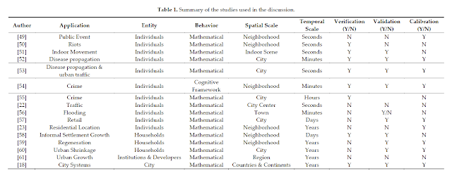
Recently, Alison Heppenstall, Nick Malleson  and myself have just had a paper accepted in Systems entitled: “Space, the Final Frontier”: How Good are Agent-Based Models at Simulating Individuals and Space in Cities?” In the paper we critically examine how well agent-based models have  simulated a variety of urban processes. We discus what considerations are needed when choosing the appropriate level of spatial analysis and time frame to model urban phenomena and what role Big Data can play in agent-based modeling. Below you can read the abstract of the paper and see a number of example applications discussed.

Abstract: Cities are complex systems, comprising of many interacting parts. How we simulate and understand causality in urban systems is continually evolving. Over the last decade the agent-based modeling (ABM) paradigm has provided a new lens for understanding the effects of interactions of individuals and how through such interactions macro structures emerge, both in the social and physical environment of cities. However, such a paradigm has been hindered due to computational power and a lack of large fine scale datasets. Within the last few years we have witnessed a massive increase in computational processing power and storage, combined with the onset of Big Data. Today geographers find themselves in a data rich era. We now have access to a variety of data sources (e.g., social media, mobile phone data, etc.) that tells us how, and when, individuals are using urban spaces. These data raise several questions: can we effectively use them to understand and model cities as complex entities? How well have ABM approaches lent themselves to simulating the dynamics of urban processes? What has been, or will be, the influence of Big Data on increasing our ability to understand and simulate cities? What is the appropriate level of spatial analysis and time frame to model urban phenomena? Within this paper we discuss these questions using several examples of ABM applied to urban geography to begin a dialogue about the utility of ABM for urban modeling. The arguments that the paper raises are applicable across the wider research environment where researchers are considering using this approach.

Keywords: cities; agent-based modeling; big data; crime; retail; space; simulation

Figure 1. (A) System structure; (B) System hierarchy; and (C) Related subsystems/processes (adapted from Batty, 2013).

Reference cited:

Batty, M. (2013).  The New Science of Cities; MIT Press: Cambridge, MA, USA.

Full reference to the open access paper:

Heppenstall, A., Malleson, N. and Crooks A.T. (2016). “Space, the Final Frontier”: How Good are Agent-based Models at Simulating Individuals and Space in Cities?, Systems, 4(1), 9; doi: 10.3390/systems4010009 (pdf)


Continue reading »

AAG 2015 notes – day 1

At 8:00 I’ve attended the Digital Connectivity, Inclusion, and Inequality at the World’s Economic Peripheries  session asking ‘what difference people expect better connectivity to make at the world’s economic peripheries’. I took notes from the presentations of Nancy Ettlinger, Dorothea Kleine and Lisa Poggiali. Nancy Ettlinger analysed crwodsourcing from governance perspective – using Foucauldian analysis. She looks at … Continue reading AAG 2015 notes – day 1

Continue reading »

Book review: A Framework for Geodesign:

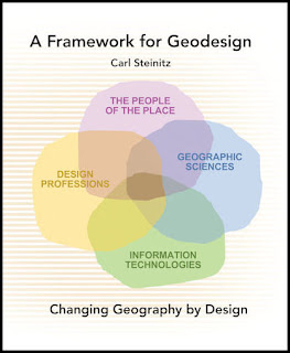
Recently I had the pleasure of reading and reviewing the book entitled “A Framework for Geodesign: Changing Geography by Design” by Carl Steinitz. The full review can be found in Environment and Planning B. However, I thought I would share the review to readers of the blog (with some added images).

“People have designed and changed the geography of their landscapes for thousands of years, for the better or for the worse. But with more pressure being placed on the world’s resources, with increasing numbers of people, the question that we are now faced with is, what are the best sustainable design solutions to mitigate these challenges? For example, urban growth is inevitable given the increasing concentration of people living within in cities, and as a trend is expected to continue into the foreseeable future. The question that designers and planners are therefore faced with is what scenarios would lead to say the least amount of loss in biodiversity. But this is a multi-faceted problem ranging in scale from how do people build there homes, to where should new industry be located, or how should land be conserved etc? These are all questions involving spatial decision-making, and where geographic information systems can play an important role. Over the last forty years, geographic information systems (GIS) have increasingly been used to assist in such complex decisions, from modelling urban growth projections through to assessing the spread of pollution (see Longley et al., 2010 for a extensive list of applications). However, one of the original visions for GIS, which is often overlooked, is that of a tool for design (Goodchild, 2010).

In his book “A Framework for Geodesign: Changing Geography by Design” Karl Steinitz brings his vast experience as a landscape architect and planner to such an issue. For those not familiar to the term geodesign, Steinitz (2012) writes in his preference to the book that it “is an invented word, and a very useful term to describe an activity that is not the territory of any single design profession, geographic science or information technology” (p ix). More generally Steinitz (2012) frames geodesign as “the development and application of design-related processes intended to change the geographical study areas in which they are applied and realised” (p1). Or another way of putting it, the merging of geography and design through computers. This is reiterated later on by a quote from Michael Flaxman were he states “Geodesign is a design and planning method which tightly couples the creation of design proposals with impact simulations informed by geographic contexts, systems thinking, and digital technology” (Flaxman quoted in Steinitz, 2012 p 12).

Moreover, geodesign can be considered both as a verb and as a noun which Steinitz relates to design more generally (see Steinitz, 1995). In the sense as a verb, geodesign is about asking questions and as a noun, geodesign is the content of the answers. In this book Steinitz not only clears up the meaning of geodesign but more importantly provides a comprehensive framework (based on his past work) for thinking about strategies of geodesign, and for organising and operationalizing these meanings.

The book is made up of twelve chapters and split into four parts. The first part is spent on framing geodesign and to set the scene for the remainder of book. For example, chapter 1 notes that for geodesign to be successful, one requires collaboration between the design professions (e.g. architects, planners, urban designers, etc.), geographical sciences (e.g. geographers, ecologists, etc), information technologies and those people living within the communities where geodesign is being applied. This is reiterated throughout the book. Chapter 1 also traces the history of geodesign, and how the advent of computer methods for the acquisition, management and display of digital data can be used to link many participants, thus making design not a solitary activity. Chapter 2 introduces the reader to the context for geodesign in the sense that 1) geography matters and that different societies think differently about their geography, 2) scale maters in the sense of what scale should a geodesign project be applied at (e.g., local, regional or global), and what are the appropriate considerations that need to incorporated at each scale, and finally 3) size matters, if the size of the geographic study area increases, there is a high risk of a harmful impact if one makes a mistake.

Part 2 of the book lays out a framework for geodesign. It is important to note that Steinitz does not call this a methodology for geodesign, as he argues one cannot have a singular methodology as the approaches, principles and methods are applied to projects across a range of geographies, scales and sizes. He therefore introduces a framework as a verb, specifically for asking questions, choosing among many methods and seeking possible answers. In order to develop this framework Steinitz walks the reader through six different questions and types of models common in geodesign projects.

Chapter 3 focuses on components of the framework and the questions one needs to address for a successful geodesign project. These questions broadly range from: 1) How should the study area be described? 2) How does the study area operate? 3) Is the current study area working well? 4) How might the study area be altered? 5) What differences might the changes cause?, and finally, 6) How should the study area be changed? As posed by Steinitz, these questions are not a linear progression, but have several iterative loops and feedbacks both with the geodesign team and the application stakeholders. Moreover, Steinitz argues that such questions should be asked three times during the geodesign study, the first to treat them as why questions (e.g. to understand the geographic study area and the scope of the study). Secondly, the questions are asked in reverse order to identify the how questions (e.g. to define the methods of the study, therefore geodesign becomes a decision rather than data driven process) and finally, the questions are asked in sequential order to address the what, where and when questions as the geodesign study is being implemented. Once these three iterations are complete, there can be three possible decisions, yes, no and maybe. If maybe or no, more feedback is needed between the geodesign team and the stakeholders. These iterations highlight how geodesign is an on-going process of changing geography by design.
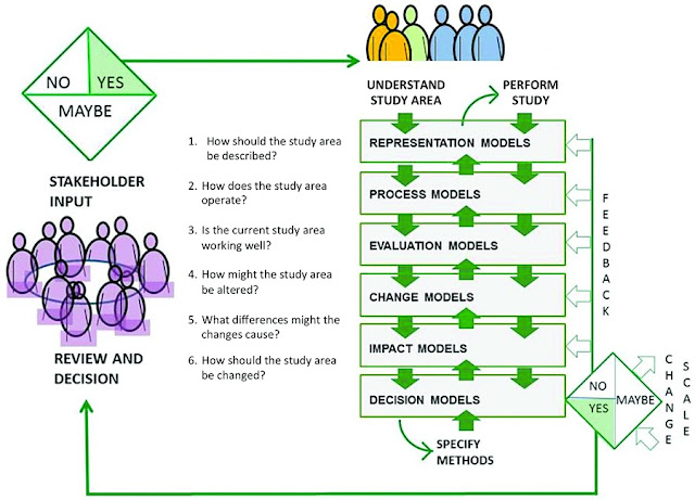
Using this framework, Chapter 4 discusses the first iteration of questions, that of scoping the geodesign study. The emphasis of this iteration is ensuring that it is being decision-driven as opposed to data-driven. Moreover, it goes over the six questions in an attempt to identity the intended scope for the study before looking at a feasible methodological plan. Chapter 5, moves onto the second iteration, that of designing the study methodology. Having identified the scope of the study (the why) from the first iteration, the geodesign team must then explore how it will be carried out and what are the evaluation criteria. Chapter 6 discusses the third iteration, that of carrying out the geodesign study. That of the what, where and when questions. Throughout these chapters, Steinitz reiterates the need for stakeholder input and feedback from the geodesign team. Moreover, at the end of chapter 6, Steinitz reiterates that the choices mater. The why questions provide a sense of the scope and objectives of the design application: the problem, the study area and those scales required for operationalizing a successful project.
Part 3 of the book looks at nine case studies in geodesign from around the world. Ranging in temporal scale from days to years, from no financial budget to a large budget, and from a small to large numbers of participants. These case studies helped solidify many of the concepts identified in the preceding chapters. They range from urban growth, to urban change to that of fire management. The case studies focus on specific places and utilize GIS with a variety of different techniques, from anticipatory modelling to that of participatory modelling and rule based models (e.g. cellular automata). They also show the importance of visualisation, as Steinitz (2012) notes “spatial visualisation can significantly influence decision making” (p 168). These examples have details but not depth (however, references are given to the full case study report), but this reiterates the purpose of the book, in the sense it is not a “how to” textbook or listing technologies that enable geodesign. It is a discussion with examples of geodesign. Or to quote from the last page of the book “you cannot copy an example but you can gain experience by joining the collaborative activities of geodesign and changing geography by design” (Steinitz, 2012, p 201). The same goes for the applications, they give a valuable insight into what is possible with geodesign. The book concludes by discussing the future applications for geodesign which range from looking at the implications for research in geodesign, and sketching out a geodesign support system (see Ervin, 2011); and in a sense, one could relate this to other planning support systems (see Brail, 2008), but with a greater emphasis on design.

Overall the book is extremely well written and Steinitz provides a critical and personal account of geodesign, which shows his expertise in the area from his years of teaching and carrying out geodesign work. The use of figures and real world examples really helps support the discussion. But if you are looking for a textbook for “how to” do geodesign, or a list of technologies that enable geodesign, you need to look elsewhere. This is a book the principles and practice of geodesign in a general sense, and which provides a valuable resource for those interested in this topic.”

References:

Brail, R.K. (ed.) (2008), Planning Support Systems for Cities and Regions, Lincoln Institute of Land Policy, Cambridge, MA.
Ervin, S. (2011), ‘A System for GeoDesign’, Proceedings of Digital Landscape Architecture, Anhalt University of Applied Science, Dessau, Germany, pp. 145-154.
Goodchild, M.F. (2010), ‘Towards Geodesign: Repurposing Cartography and GIS?.’ Cartographic Perspectives, 66(7-22).
Longley, P.A., Goodchild, M.F., Maguire, D.J. and Rhind, D.W. (2010), Geographical Information Systems and Science (3rd Edition), John Wiley & Sons, New York, NY.
Steinitz, C. (1995), ‘Design is a Verb; Design is a Noun’, Landscape Journal, 14(2): 188-200.
Steinitz, C. (2012), A Framework for Geodesign: Changing Geography by Design, ESRI Press, Redlands. CA.

Full reference to the book:

Review of Steinitz, C. (2012), A Framework for Geodesign: Changing Geography by Design, ESRI Press, Redlands. CA.

Full reference to the review:

Crooks, A.T. (2013), Crooks on Steinitz: A Framework for Geodesign: Changing Geography by Design, Environment and Planning B, 40 (6): 1122-1124.

Continue reading »

Book review: A Framework for Geodesign:

Recently I had the pleasure of reading and reviewing the book entitled “A Framework for Geodesign: Changing Geography by Design” by Carl Steinitz. The full review can be found in Environment and Planning B. However, I thought I would share the review to readers of the blog (with some added images).

“People have designed and changed the geography of their landscapes for thousands of years, for the better or for the worse. But with more pressure being placed on the world’s resources, with increasing numbers of people, the question that we are now faced with is, what are the best sustainable design solutions to mitigate these challenges? For example, urban growth is inevitable given the increasing concentration of people living within in cities, and as a trend is expected to continue into the foreseeable future. The question that designers and planners are therefore faced with is what scenarios would lead to say the least amount of loss in biodiversity. But this is a multi-faceted problem ranging in scale from how do people build there homes, to where should new industry be located, or how should land be conserved etc? These are all questions involving spatial decision-making, and where geographic information systems can play an important role. Over the last forty years, geographic information systems (GIS) have increasingly been used to assist in such complex decisions, from modelling urban growth projections through to assessing the spread of pollution (see Longley et al., 2010 for a extensive list of applications). However, one of the original visions for GIS, which is often overlooked, is that of a tool for design (Goodchild, 2010).

In his book “A Framework for Geodesign: Changing Geography by Design” Karl Steinitz brings his vast experience as a landscape architect and planner to such an issue. For those not familiar to the term geodesign, Steinitz (2012) writes in his preference to the book that it “is an invented word, and a very useful term to describe an activity that is not the territory of any single design profession, geographic science or information technology” (p ix). More generally Steinitz (2012) frames geodesign as “the development and application of design-related processes intended to change the geographical study areas in which they are applied and realised” (p1). Or another way of putting it, the merging of geography and design through computers. This is reiterated later on by a quote from Michael Flaxman were he states “Geodesign is a design and planning method which tightly couples the creation of design proposals with impact simulations informed by geographic contexts, systems thinking, and digital technology” (Flaxman quoted in Steinitz, 2012 p 12).

Moreover, geodesign can be considered both as a verb and as a noun which Steinitz relates to design more generally (see Steinitz, 1995). In the sense as a verb, geodesign is about asking questions and as a noun, geodesign is the content of the answers. In this book Steinitz not only clears up the meaning of geodesign but more importantly provides a comprehensive framework (based on his past work) for thinking about strategies of geodesign, and for organising and operationalizing these meanings.

The book is made up of twelve chapters and split into four parts. The first part is spent on framing geodesign and to set the scene for the remainder of book. For example, chapter 1 notes that for geodesign to be successful, one requires collaboration between the design professions (e.g. architects, planners, urban designers, etc.), geographical sciences (e.g. geographers, ecologists, etc), information technologies and those people living within the communities where geodesign is being applied. This is reiterated throughout the book. Chapter 1 also traces the history of geodesign, and how the advent of computer methods for the acquisition, management and display of digital data can be used to link many participants, thus making design not a solitary activity. Chapter 2 introduces the reader to the context for geodesign in the sense that 1) geography matters and that different societies think differently about their geography, 2) scale maters in the sense of what scale should a geodesign project be applied at (e.g., local, regional or global), and what are the appropriate considerations that need to incorporated at each scale, and finally 3) size matters, if the size of the geographic study area increases, there is a high risk of a harmful impact if one makes a mistake.

Part 2 of the book lays out a framework for geodesign. It is important to note that Steinitz does not call this a methodology for geodesign, as he argues one cannot have a singular methodology as the approaches, principles and methods are applied to projects across a range of geographies, scales and sizes. He therefore introduces a framework as a verb, specifically for asking questions, choosing among many methods and seeking possible answers. In order to develop this framework Steinitz walks the reader through six different questions and types of models common in geodesign projects.

Chapter 3 focuses on components of the framework and the questions one needs to address for a successful geodesign project. These questions broadly range from: 1) How should the study area be described? 2) How does the study area operate? 3) Is the current study area working well? 4) How might the study area be altered? 5) What differences might the changes cause?, and finally, 6) How should the study area be changed? As posed by Steinitz, these questions are not a linear progression, but have several iterative loops and feedbacks both with the geodesign team and the application stakeholders. Moreover, Steinitz argues that such questions should be asked three times during the geodesign study, the first to treat them as why questions (e.g. to understand the geographic study area and the scope of the study). Secondly, the questions are asked in reverse order to identify the how questions (e.g. to define the methods of the study, therefore geodesign becomes a decision rather than data driven process) and finally, the questions are asked in sequential order to address the what, where and when questions as the geodesign study is being implemented. Once these three iterations are complete, there can be three possible decisions, yes, no and maybe. If maybe or no, more feedback is needed between the geodesign team and the stakeholders. These iterations highlight how geodesign is an on-going process of changing geography by design.

Using this framework, Chapter 4 discusses the first iteration of questions, that of scoping the geodesign study. The emphasis of this iteration is ensuring that it is being decision-driven as opposed to data-driven. Moreover, it goes over the six questions in an attempt to identity the intended scope for the study before looking at a feasible methodological plan. Chapter 5, moves onto the second iteration, that of designing the study methodology. Having identified the scope of the study (the why) from the first iteration, the geodesign team must then explore how it will be carried out and what are the evaluation criteria. Chapter 6 discusses the third iteration, that of carrying out the geodesign study. That of the what, where and when questions. Throughout these chapters, Steinitz reiterates the need for stakeholder input and feedback from the geodesign team. Moreover, at the end of chapter 6, Steinitz reiterates that the choices mater. The why questions provide a sense of the scope and objectives of the design application: the problem, the study area and those scales required for operationalizing a successful project.
Part 3 of the book looks at nine case studies in geodesign from around the world. Ranging in temporal scale from days to years, from no financial budget to a large budget, and from a small to large numbers of participants. These case studies helped solidify many of the concepts identified in the preceding chapters. They range from urban growth, to urban change to that of fire management. The case studies focus on specific places and utilize GIS with a variety of different techniques, from anticipatory modelling to that of participatory modelling and rule based models (e.g. cellular automata). They also show the importance of visualisation, as Steinitz (2012) notes “spatial visualisation can significantly influence decision making” (p 168). These examples have details but not depth (however, references are given to the full case study report), but this reiterates the purpose of the book, in the sense it is not a “how to” textbook or listing technologies that enable geodesign. It is a discussion with examples of geodesign. Or to quote from the last page of the book “you cannot copy an example but you can gain experience by joining the collaborative activities of geodesign and changing geography by design” (Steinitz, 2012, p 201). The same goes for the applications, they give a valuable insight into what is possible with geodesign. The book concludes by discussing the future applications for geodesign which range from looking at the implications for research in geodesign, and sketching out a geodesign support system (see Ervin, 2011); and in a sense, one could relate this to other planning support systems (see Brail, 2008), but with a greater emphasis on design.

Overall the book is extremely well written and Steinitz provides a critical and personal account of geodesign, which shows his expertise in the area from his years of teaching and carrying out geodesign work. The use of figures and real world examples really helps support the discussion. But if you are looking for a textbook for “how to” do geodesign, or a list of technologies that enable geodesign, you need to look elsewhere. This is a book the principles and practice of geodesign in a general sense, and which provides a valuable resource for those interested in this topic.”

References:

Brail, R.K. (ed.) (2008), Planning Support Systems for Cities and Regions, Lincoln Institute of Land Policy, Cambridge, MA.
Ervin, S. (2011), ‘A System for GeoDesign’, Proceedings of Digital Landscape Architecture, Anhalt University of Applied Science, Dessau, Germany, pp. 145-154.
Goodchild, M.F. (2010), ‘Towards Geodesign: Repurposing Cartography and GIS?.’ Cartographic Perspectives, 66(7-22).
Longley, P.A., Goodchild, M.F., Maguire, D.J. and Rhind, D.W. (2010), Geographical Information Systems and Science (3rd Edition), John Wiley & Sons, New York, NY.
Steinitz, C. (1995), ‘Design is a Verb; Design is a Noun’, Landscape Journal, 14(2): 188-200.
Steinitz, C. (2012), A Framework for Geodesign: Changing Geography by Design, ESRI Press, Redlands. CA.

Full reference to the book:

Review of Steinitz, C. (2012), A Framework for Geodesign: Changing Geography by Design, ESRI Press, Redlands. CA.

Full reference to the review:

Crooks, A.T. (2013), Crooks on Steinitz: A Framework for Geodesign: Changing Geography by Design, Environment and Planning B, 40 (6): 1122-1124.

Continue reading »

GIS chapter in ‘Introducing Human Geographies’

There is something in the physical presence of book that is pleasurable. Receiving the copy of Introducing Human Geographies was special, as I have contributed a chapter about Geographic Information Systems to the ‘cartographies’ section. It might be a response to Ron Johnston critique of Human Geography textbooks or a decision by the editors to extend the […]

Continue reading »

GeoHCI 2013 – Geography meet Human-Computer Interaction

CHI (Computer-Human Interaction) is the premier conference in the calendar of Human-Computer Interaction (HCI) studies. While the first paper that deal with geographic technologies within this conference was presented in 1991 (it was about User Interfaces for Geographic Information Systems by Andrew Frank and presented at a special interest group meeting), geography did not received much attention […]

Continue reading »

Transactions of the Institute of British Geographers vritual issue on GIScience

Since early 2010, I had the privilege of being a member of the editorial board of the journal Transactions of the Institute of British Geographers . It is a fascinating position, as the journal covers a wide range of topics in geography, and is also recognised as one of the top journals in the field […]

Continue reading »

A Spatial Approach to Location Quotients

The intent of this post is not simply to uncover where the highest density of people belonging to a particular ethnic group are, but rather to use the ‘location quotient’ (LQ) technique to compare the ethnic density in any one area to the overall ethnic density in Southwark, thus providing a relative insight into where […]

Continue reading »

Joined the Editorial Board of Human Biology

Pablo Mateos joins the Editorial Board of the journal Human Biology Human Biology is the official publication of the American Association of Anthropological Genetics (AAAG). It publishes multidisciplinary articles on human biology and evolution with an anthropological focus.  It has proved as … Continue reading

Continue reading »

Some Thoughts on the US Critical Facilities List

Naturally, as a Geographer the wikileaks release of facilities that the US believes critical to its security was interesting. Much like the chaps over at Floatingsheep some of us (Martin Austwick, James Cheshire, Peter Baudains, Alex Braithwaite) took it upon ourselves to map out the reported list. Martin came up with the following visualisation that […]

Continue reading »

Finnish Municipalities: A case for zone design?

In Finland, municipalities are incredibly powerful; like local authorities in the UK, municipalities are responsible for local administration, but they also levy an income tax and are responsible for providing most public services. Municipalities were founded on the assumption of equality, which forms the basis for the reform considerations currently ongoing in the Finnish government. […]

Continue reading »