Where in the UK do people swear most on Twitter? – BBC News
Where in the UK do people swear most on Twitter? BBC NewsResearch reveals the areas of the UK in which Twitter users are most likely to use coarse language.
Continue reading »The latest outputs from researchers, alumni and friends at the UCL Centre for Advanced Spatial Analysis (CASA).

Where in the UK do people swear most on Twitter? BBC NewsResearch reveals the areas of the UK in which Twitter users are most likely to use coarse language.
Continue reading »BBC NewsBBC Local Live: Oxfordshire on Wednesday 10 September 2014BBC NewsResearchers from the Centre for Advanced Spatial Analysis (CASA) at University College London monitored all geo-located tweets sent from smartphones in the UK. The findings, take…
Continue reading »BBC News |
BBC Local Live: North-east England on Wednesday 10 September 2014
BBC News St James’ Park will host six games across two days at the end of May featuring 12 Super League clubs. The league says the fixtures and kick-off times will be confirmed in mid-November. Previous Super League Magic Weekend venues include, Etihad … |
BBC NewsBlyth swimmer in near-miss with cargo shipBBC NewsA swimmer involved in a near miss with a cargo ship said he was taking a dip in the harbour because it was cheaper than the local pool. An RNLI lifeboat was called to the Port of Blyth in Northu…
Continue reading »Telegraph.co.uk |
It’s official: football fans really do love swearing
Telegraph.co.uk The research was conducted for a new Radio 4 series, Future Proofing, by Dr Hannah Fry, a lecturer in the mathematics of cities at the Centre for Advanced Spatial Analysis (CASA) at UCL. Dr Fry monitored Twitter activity in the UK from any tweet sent … Where in the UK do people swear most on Twitter?BBC News Redcar: where Twitter is a dirty word (actually, lots of them)The Independent Strabane is the last word in tweets full of bad languageBelfast Telegraph |
Telegraph.co.ukWhere in the UK do people swear most on Twitter?BBC NewsResearch has revealed the areas of the UK in which Twitter users are most likely to swear in their posts. Researchers from the Centre for Advanced Spatial Analysis (CASA) at Univers…
Continue reading »The IndependentRedcar: where Twitter is a dirty word (actually – lots of them)The IndependentScientists at the Centre for Advanced Spatial Analysis (CASA) at UCL investigated patterns of Twitter profanity by monitoring tweets sent from a smartphone wit…
Continue reading »BBC News |
Middlesbrough Council’s £4.5m swing bridge gets go ahead
BBC News Plans have been approved for a £4.5m swing bridge to cross part of the River Tees in Middlesbrough. The vehicle and pedestrian bridge will be built at the entrance to Middlehaven Dock, Middlesbrough Council said. More than £150m is already being … |
 The Transport Map Books are available for each local authority district in England and present a series of maps related to commuting behaviour. The data are derived from multiple sources including: the 2011 Census, Department for Transport estimates and the results of a research project looking at carbon dioxide emissions linked to the school commute.
All the maps are available to download HERE; and the R code used to create them and the emissions model is on Github.

These data relate to Middle Layer Super Output Area (MSOA) level estimates of travel to work flows by transport mode. The raw data are available from the ONS. For the maps, the flows have been limited to those both originating and terminating within each local authority district.

The Department of Transport provide a range of statistics at Lower Layer Super Output Area level about accessibility and connectivity to a series of key services. A subset of variables were mapped.

These data were generated as part of an ESRC funded project investigating emissions associated with the school commute. The model provides an estimate of the carbon dioxide emitted at Lower Layer Super Output Area level. For full details of the methodology, see the open access paper:
Singleton, A. (2013) A GIS Approach to Modelling CO2 Emissions Associated with the Pupil-School Commute. International Journal of Geographical Information Science, 28(2):256–273.

These attributes were extracted from the 2011 census data provided by Nomis at Output Area level.

Workplace zones are a new geography for the 2011 census for the dissemination of daytime population statistics. A number of attributes were selected related to transport, and also were downloaded from Nomis.
When you look at the discussions that are emerging around the term ‘Citizen Science‘, you can often find discussion about the ‘Citizen‘ part of the term. What about the ‘Science‘ part? This is something that once you start being involved in Citizen Science you are forced to contemplate. As Francois Grey like to note ‘Science is too important […]![]()
BBC NewsOfficers probe scene of fatal Kidlington house fireBBC NewsResearchers from the Centre for Advanced Spatial Analysis (CASA) at University College London monitored all geo-located tweets sent from smartphones in the UK. The findings, taken from …
Continue reading »BBC NewsUpper Arncott 40-acre solar farm approved by councillorsBBC NewsApproval was granted by Cherwell District Council for solar panels to be built in Upper Arncott. The eight megawatt solar photovoltaic farm will be built on an agricultural field c…
Continue reading »BBC NewsPlan for 54 homes in Hook Norton rejected by councilBBC NewsResearchers from the Centre for Advanced Spatial Analysis (CASA) at University College London monitored all geo-located tweets sent from smartphones in the UK. The findings, taken from…
Continue reading »Alex Singleton – Cities and context: The codification of small areas through geodemographic classification from The Programmable City on Vimeo.
Talk given at NUI Maynooth – Code and the City, 3-4 September 2014.
Continue reading »The Lost Labyrinth of Ancient Egypt – Part 2 Ancient Origins(Read Part 1 ) The lost labyrinth of ancient Egypt is a colossal temple said to contain 3,000 beautifully adorned rooms connected by a confusing array of …
Continue reading »BBC NewsSpace studio school opens its doors in BanburyBBC NewsResearchers from the Centre for Advanced Spatial Analysis (CASA) at University College London monitored all geo-located tweets sent from smartphones in the UK. The findings, taken from 28 Au…
Continue reading »
The 2011 Area Classification for Output Areas, or 2011 OAC, is a geodemographic classification that was developed by Dr Chris Gale during his Ph.D at UCL Geography over the last few years, in close conjunction with the Office for National Statistics, who have endorsed it and adopted it as their official classification and who collected […]
Continue reading »TweetGeoHealth Laboratory, University of Canterbury, Christchurch, New Zealand Post based in Wellington Researcher in Health Geography, GeoHealth Laboratory, based in Wellington This is a 2.5 year fixed term position. The successful applicant will have interests in the following areas; neighbourhoods and health, environmental justice and health, environment and health, impacts of urban environment on […]
Continue reading »The Guardian |
Try this 3D rollercoaster for the Oculus Rift headset. Could it help plan cities?
The Guardian The Bartlett Centre for Advanced Spatial Analysis (Casa) at UCL in London, where Dawkins studies, had set out to show how a virtual rollercoaster could demonstrate to the Grand Designs Live exhibition’s 100,000 visitors a more tangible example of how … |

I attended the Big Data and Urban Informatics workshop in UIC Chicago in early August. My previous blog post outlined my presentation at the workshop. Here’s my notes and thoughts on some of the other talks that I attended. Above, the AURIN Workbench is a sophisticated platform for city authorities in Australia to output their […]
Continue reading »I’ve been experimenting with 3D buildings in my virtual globe project and it’s now progressed to the point where I can demonstrate it working with dynamically loaded content. The following YouTube clip shows the buildings for London, along with the Thames. I didn’t have the real heights, so buildings are extruded up by a random …
Read more →
Particle Flow is a versatile, powerful particle system for Autodesk’s 3ds Max. It employs an event-driven model, using a special dialog called Particle View, allowing you to combine…
Continue reading »TweetThis forthcomingmeeting will be held at LSE on Friday 24th October 2014, 10.30am-5.00pm. The main question to be addressed is: ‘Is the concept of ‘usual residence’ reaching its sell-by date?’ Now that the Government has confirmed that a further Population Census will take place in 2021, it is an opportune time to consider how far […]
Continue reading »The National Library of Scotland’s (NLS) Map Depa […]
Continue reading »Try this 3D rollercoaster for the Oculus Rift headset. Could it help plan cities? The GuardianIn May, Oliver Dawkins wowed the crowds at an architecture exhibition in east London. The UCL student had designed a 3D rollercoaster ride for the …
Continue reading »Try this 3D rollercoaster for the Oculus Rift headset. Could it help plan cities? The GuardianIn May, Oliver Dawkins wowed the crowds at an architecture exhibition in east London. The UCL student had designed a 3D rollercoaster ride for the …
Continue reading »Try this 3D rollercoaster for the Oculus Rift headset. Could it help plan cities? The GuardianIn May, Oliver Dawkins wowed the crowds at an architecture exhibition in east London. The UCL student had designed a 3D rollercoaster ride for the …
Continue reading »The 3 days of the Royal Geographical Society (with IBG) or RGS/IBG annual conference are always valuable, as they provide an opportunity to catch up with the current themes in (mostly human) Geography. While I spend most of my time in an engineering department, I also like to keep my ‘geographer identity’ up to date as this […]![]()
I’ve written in the past (and here) about how difficult I’ve found it to get my hands on a book about visualisation that’s a real page turner – this must be a problem that greater minds than I have struggled … Continue reading →![]()

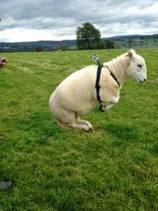
“The first rule: The sheepdog learns how to make the sheep come together in a flock. The second rule: Whenever the sheep are in a tightly knit group, the dog pushes them forwards.” (BBC)
Strömbom. D. Mann, R. P., Wilson, A. M., Hailes, S., Morton, A. J., Sumpter, D. J. T., King, A. J. (2014) Solving the shepherding problem: Heuristics for herding autonomous, interacting agents. Journal of the Royal Society Interface, 11: 20140719.
BBC NewsNewcastle United open garden for MH17 fans Liam Sweeney and John AlderBBC NewsNewcastle United have opened a memorial garden in honour of the two fans killed in the MH17 air disaster while flying out to see the team play. Liam Sweeney and John …
Continue reading »Earlier this month, I gave a short presentation at the Big Data and Urban Informatics Workshop, which took place at UIC (University of Illinois in Chicago). My presentation was an abridged version of a paper that I prepared for the workshop. In due course, I plan to publish the full paper, possibly as a CASA […]
Continue reading »Mapping London is just back from a holiday in New York […]
Continue reading »Earlier this year CASA was invited to create a virtual reality exhibit for the Walking on Water exhibition, partnered with Grand Designs Live at London’s…
Continue reading »Together with a colleague, I have been involved in the “hard” task of drafting a diagram (or a “mindmap”) that would connect logically, some of the “buzz words” regarding “data science”; e.g.: artificial intelligence, machine learning, data mining, recommenders. Moreover … Continue reading →![]()
Mapping London is on holiday in New York City this week […]
Continue reading »Mapping London is currently abroad on holiday. So here& […]
Continue reading »