
Category: visualisation

Improved Tree Maps with R
“Treemaps display hierarchical (tree-structured) data as a set of nested rectangles. Each branch of the tree is given a rectangle, which is then tiled with smaller rectangles representing sub-branches. A leaf node’s rectangle has an area proportional to a specified dimension on the data. Often the leaf nodes are colored to show a separate dimension of …
Continue reading »Mapping GCSE Scores
In the UK, August is exam results month for 16-18 year olds. Every year, photos of leaping teenagers clutching their results are accompanied by reports of record attainment rates, debates around how challenging modern exams are and, more so recently than ever, concerns for the number of sixth form and university places. Back in March …
Continue reading »England Riots: Offences Committed and Offenders Age
The Guardian have been keeping track of the magistrate cases and convictions resulting from the recent rioting in England. Using this data I have produced the “tree map” below. For each magistrate I have grouped each offence committed and represented it as a square. The size of the square represents the number of people who …
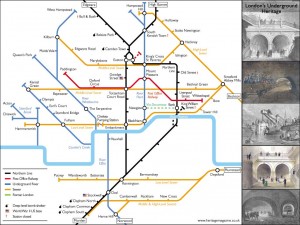
Continue reading »8-Bit London
It’s a bit silly, and not exactly very helpful as […]
Continue reading »Networks Networks
The main buzz word of the 2011 discussion in urban and spatial research is networks. Networks start to appear everywhere and everything is linked in to most other things. This is however, in fact not new. The network discussion has started at least ten…
Continue reading »Extracting Data from PDFs: Clean Air in Schools
A lot of the maps I have created over the last few years have started out as tabular data in PDF documents. A recent BBC London report contained a dataset obtained from TfL of all the schools in London which are within 150 metres of a road carrying 10,000 vehicles a day or more. The report is a […]
Continue reading »Plant Grow TimeLapse – Asparagus
Temporal dimensions are only visible as fractions and over a very small scale. There are very clear limitations to the recognition of temporal changes to the human senses. This ranges from about 18 frames per second to the movement of a snail. Everythi…
Continue reading »Sense and the City at the Transport Museum
A new exhibition – Sense and the City – ope […]
Continue reading »Global Social Network Use – the Stats
Social networking is an internet phenomena and as such not limite to political borders. It spread rather quickly around the globe and is now as a range of maps recently has shown present on al continents as an important part of internet usage. THere ar…
Continue reading »Book – Model Making: Physical Ideas
With the possibilities of new computer technologies and the availability of rendering power physical models in architecture have lost the role as the main tool for spatial and physical shaping and testing of ideas. It is convenient with a few clicks t…
Continue reading »SubMap – Subjective Map
The discussion around the subjectivity of mapping and the potential of subjective mapping tools becoming possible with the ever greater penetration of gadgets an locative media is gaining momentum. There are a number of project focusing on the output o…
Continue reading »SubMap – Subjective Map
The discussion around the subjectivity of mapping and the potential of subjective mapping tools becoming possible with the ever greater penetration of gadgets an locative media is gaining momentum. There are a number of project focusing on the output o…
Continue reading »TubeViz – Tube Station Passenger Footfall
From Daniela Krug and Lars Malmqvist comes TubeViz R […]
Continue reading »Contouring Data
It’s been a while since I did any Fortran. I’ve been looking into contouring algorithms and decided to have a look at Paul Bourke’s Conrec program that was originally published in Byte magazine in 1987: http://paulbourke.net/papers/conrec The graph above shows the underlying data values as a coloured square grid with the black contour lines on […]
Continue reading »Drawing New York
Nike is one of the very big brands managing to cleverly connect to their customers through both very good marketing and a product range always catching and inspiring the trends. So they were very early to offer an iPod extension to connect their sport …
Continue reading »Drawing New York
Nike is one of the very big brands managing to cleverly connect to their customers through both very good marketing and a product range always catching and inspiring the trends. So they were very early to offer an iPod extension to connect their sport …
Continue reading »Mediating Mediums – a Vision in 3D
The digital 3rd dimension is a long standing topic in many disciplines and together with augmented reality technologies has had a tremendous boost. Most smart phone platforms these days offer tools and applications to integrate and use AR style package…
Continue reading »Exploring the Historical Determinants of Urban Growth Patterns through Cellular Automata
Kiril Stanilov has adapted RIKS METRONAMICA, an established cellular automata (CA) modelling system, to simulate the historical growth of a section of a large world city. The focus is on simulating change from the late 19th century until the modern …
Continue reading »A Week on Foursquare and Twitter
The news papers are currently not only fueling the data mining trend, they are pushing it themselves. The New York Times is leading the way with the data viz lab, but also the Guardian with the data blog is very active. Now the Wall Street Journal is p…
Continue reading »London’s Rail System as a Network
As many of you know, for quite some time I’ve been wrestling with a massive data set from TfL — I make it that I have 120 million trip segments across 88 million identifiable journeys in the course of just …
Continue reading »Weather Underground
I’ve been looking at the Weather Underground API (http://wiki.wunderground.com/index.php/API_-_XML) which gives access to the observation stations and the data they are collecting. The API uses simple commands to query for a list of stations, for example: http://api.wunderground.com/auto/wui/geo/GeoLookupXML/index.xml?query=london,united+kingdom Using C# and .net, this is accomplished as follows: WebRequest request = WebRequest.Create(string.Format(GeoLookupXML, @”london,united+kingdom”)); HttpWebResponse response = (HttpWebResponse)request.GetResponse(); XmlDocument […]
Continue reading »Tweets in London
Many Twitter messages, or “tweets”, are sen […]
Continue reading »Data Globe by Google – Chrome Experiments
Google presents fir the currently running I/O conference in San Francisco a new Google Chrome Experiment. The developers print a data globe for visualisation purpose. It’s an in-house production and is a sort of simplified Google Earth in black and whi…
Continue reading »Network Population Density for Southwark
Using the excellent SANET extension for ArcGIS 9.3 I was able to take some of my data for Southwark that I had geocoded to address level, and estimate the population density using the OS Mastermap ITN product. The procedure is essentially a Kernel Density Estimation that takes place on a given network rather than across 2D space, this effectively controls […]
Continue reading »Book – Guide to Information Graphics
In most disciplines graphics, as is graphs, are not exactly new. The presentation of data, facts and figures have come to play a important role. Especially with the limited capacities of excel and other spread sheet software this was easy to do, but ne…
Continue reading »Early Views of Public Transit Usage in London
In fits and starts, over the past month I’ve been getting to grips with an exciting new Oyster Card data set from TfL and the wonderfully supportive Andrew Gaitskell, their resident Oyster Card data expert. For those few of you …
Continue reading »Datamatics Ver.2.0 – Data Viz Black and White
As part of the Spill Festival of Performance 2011 at the Barbican, Ryoji Ikeda played a set. It was another installment of his Datamatics Series started back in 2006. The new Datamatics [ver.2.0] series has evolved quite a bit from the first version al…
Continue reading »Deleted Wikipedia
The online encyclopedia Wikipedia is a great resource for quick look up and input. In the internet world of linking and explaining it is together with Google one of the central elements. Earlier this year Wikipedia celebrated its 10th anniversary. The …
Continue reading »Wanderlust – Visual Stories
To pick up on the topic discussed herre last week with the Wanderlust story app for location based narratives an other ‘Wanderlust’ interpretation using visual imagery or visual narratives possibly. This one here is a visual version traveling through C…
Continue reading »MTV Music Awards 2010 – Visualisation
THe MTV Music Awards are one of the really big yearly music shows and as such a important date in the calendar. Of course this transfers to the social networking sites, with loads of followers chatting about it online. For last years show Stamen has te…
Continue reading »LinkedIN by Numbers
The professional version of facebook has now als reached the 100 million user mark and is still growing. LinkedIN the social networking platform for the professional world has published at the beginning of March 2011 their growth in numbers to make a g…
Continue reading »Protest in the Middle East – Inception
Over the last few month Europe realised that there are changes under way in the Middle East. Since December 2010 in a number of countries around the Mediterranean and the red sea people are protesting against their regimes, essentially asking for a cha…
Continue reading »Massified Research and Visualisation
Today at the conference in Oxford ‘Visualisation in the Age of Computerisation’ we will be presenting a paper. The conference is packed and there are waiting lists for all events. This is to say how popular the topic currently is. Of course Oxford is a…
Continue reading »