Quarter of Brits suffer ‘pavement rage’ – The Telegraph
Quarter of Brits suffer ‘pavement rage’ The Telegraph
Continue reading »The latest outputs from researchers, alumni and friends at the UCL Centre for Advanced Spatial Analysis (CASA).

Quarter of Brits suffer ‘pavement rage’ The Telegraph
Continue reading »Telegraph.co.uk |
Quarter of Brits suffer ‘pavement rage’
Telegraph.co.uk Michael Batty, professor at the Centre for Advanced Spatial Analysis (CASA), University College London, said: “During busy shopping periods, the limited pavement space available is put under pressure to accommodate an increasing density of pedestrians. |
Telegraph.co.uk |
Quarter of Brits suffer ‘pavement rage’
Telegraph.co.uk Michael Batty, professor at the Centre for Advanced Spatial Analysis (CASA), University College London, said: “During busy shopping periods, the limited pavement space available is put under pressure to accommodate an increasing density of pedestrians. |
Time Out London |
Hot foot it with NikeFuel’s walking map of zone 1
Time Out London This info was then turned into a map by the Centre for Advanced Spatial Analysis, University College London, and made to look snazzy by designer David Luepschen. Pick up your map at a Nike store near you or click on the pic above for a larger version. |
This decorative map was published in or around 1946, as […]
Continue reading »
Pigeon Sim is a Kinect powered, Google Earth linked, system to fly around live data – pulling in feeds from citydashboard.org it was developed originally as part of an EPSRC funded exhibition project (ANALOGIES) in April 2012 by CASA Researcher George MacKerron (now Lecturer at the University of Sussex). It is…
Image1. The webpage of Luminous Cities_ManhattanStudying human behaviours and communication in time and space has been regarded as the important factor of modern urban planning. In this digital era, collecting online data and analysing the data provide…
Continue reading » |
| Image1. The webpage of Luminous Cities_Manhattan |
 |
| Image2. The mapping geotag data of locals and tourists by Eric Fischer
|
 |
| Image3. Twitter Languages in London, James Cheshire and Ed Manley
|
 |
| Image4. Berlin user geotag map from the webpage of Luminous Cities |
 |
| Image5. London occupy geotag map from the webpage of Luminous Cities |
 |
| Image6. Tokyo geotag map, Zoom out, from the webpage of Luminous Cities |
 |
| Image7. Tokyo geotag map, Zoom in, from the webpage of Luminous Cities |

|
| Image1. The webpage of Luminous Cities_Manhattan |
|
| Image2. The mapping geotag data of locals and tourists by Eric Fischer
|
|
| Image3. Twitter Languages in London, James Cheshire and Ed Manley
|
|
| Image4. Berlin user geotag map from the webpage of Luminous Cities |
|
| Image5. London occupy geotag map from the webpage of Luminous Cities |
|
| Image6. Tokyo geotag map, Zoom out, from the webpage of Luminous Cities |
|
| Image7. Tokyo geotag map, Zoom in, from the webpage of Luminous Cities |
It is about this time of year that I get asked if I wan […]
Continue reading »There is always interest in London’s astronomical […]
Continue reading »We have a chapter in this new book on London 2062 which is a brief summary of our transport work using big data. The chapter is called Smart London but the book covers a wide array of topics. It is … Continue reading →
Continue reading »This is a really nice video funded by the UN Foundation […]
Continue reading »This is a really nice video funded by the UN Foundation […]
Continue reading »Macroeconomics is one of those disciplines where the ideas are simple, but the lingo is complicated. Paul Krugman, in his New York Times blog, is usually great at communicating the ideas of Macroeconomics in a human-friendly way. But sometimes the language gets ahead of Krugman—sadly, most obviously when the ideas he’s expressing are important and […]
Continue reading »‘The Tomorrow People’: Cara Confesses to John, Stephen Loses His Powers and More in “Limbo” BustleThis week’s episode of The Tomorrow People is called “Limbo,” but it could just as well have been called “Confessions” or “Cara Can’t Keep a Se…
Continue reading »
It’s always irked me slightly that many online maps of London show the various tube services as straight lines between stations, or as idealised Bezier curves. Perhaps the regimented lines and angles of the official “Beck-style” tube diagram has meant that, when translating into a “real life” geographical map, people have tended to keep the […]
Continue reading »
GEOSIMULATION MODELS DESCRIPTION OF THE SESSION(S) Since the publication of Geosimulation in 2004, the use of Agent-based Modeling (ABM) and Cellular Automata (CA) under the umbrella of Geosimulation models within geographical systems have started to…
Continue reading »
GEOSIMULATION MODELS DESCRIPTION OF THE SESSION(S) Since the publication of Geosimulation in 2004, the use of Agent-based Modeling (ABM) and Cellular Automata (CA) under the umbrella of Geosimulation models within geographical systems have started to…
Continue reading »
Months of blood, sweat and tears (or rather, those all-too modern equivalents coffee, RSI and eye-strain) have been spilled in the last six months. I have an absolutely non-existent ability to concentrate on more than one thing at a time, and the one thing I’ve been thinking, dreaming and going on about non-stop for pretty […]
Continue reading »There are just some photographs that speak for themselves. Admittedly this van is positioned to watch over 1 World Trade Center but it is quite a surprise if you think it is just another police van when its camera suddenly ascends … Continue reading →
Continue reading »Down Under the Manhattan Bridge Overpass where gentrification combines with public art just north of Brooklyn Heights, I discovered one of the secrets of America in the new world of smart cities, ICT, and citizen science: data streaming. Half a … Continue reading →
Continue reading »
The Bow Roundabout is a busy and unpleasant junction in east London, with large volumes of traffic, including many bicycles and lorries. It forms a key part of the trunk network in London, distributing road-haulage around the city. River channels of the Lea Valley, industrial complexes, and the developing Olympic Park, block suitable alternative cycle […]
Continue reading »London’s craft beer and microbrewery scene is bur […]
Continue reading »CUSP – New York University’s Center for Urban Science and Progress – in launching their Masters program in Applied Urban Science and Informatics, have put together a fascinating course called Foundations of Urban Science which is being taught this fall by … Continue reading →
Continue reading »TweetApplications are welcomed from any area of quantitative geography, but we are particularly interested in candidates with research and teaching interests in the fields of economic geography, GIS, population geography, geodemographics, migration research. The lecturer will be expected to undertake research of the highest international standards within his or her own specialist field which will […]
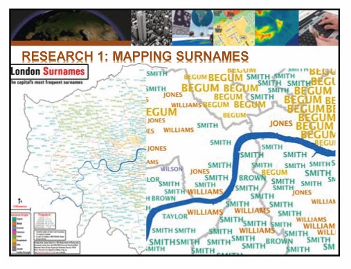
Continue reading »The second lecture of GIS comprised mainly three parts, the examples of practical research by using GIS, GIS software and the way to gain relevant data for the research. In the beginning, Dr. Adam Dennett, the lecturer of CASA, informed the…
Continue reading »
 |
| Image 1 |
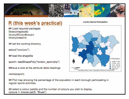
And then, he moved to GIS software industry which has been significantly growing. As interest and the utilisation of GIS are increasing, GIS software market is expanding almost 10% every year and now it is used in all industries and public sectors such as business, public safety, military and education. The popular GIS tools: Arc GIS, MAP Info, Quantum GIS, Pythonand R, and specific points of each tool were introduced. Also, small description of GIS cloud and online GIS tools was following. (Image 2)
 |
| Image 2 |
 |
| Image 3 |
 |
| Image 4 |
Continue reading »

|
| Image 1 |
And then, he moved to GIS software industry which has been significantly growing. As interest and the utilisation of GIS are increasing, GIS software market is expanding almost 10% every year and now it is used in all industries and public sectors such as business, public safety, military and education. The popular GIS tools: Arc GIS, MAP Info, Quantum GIS, Pythonand R, and specific points of each tool were introduced. Also, small description of GIS cloud and online GIS tools was following. (Image 2)
|
| Image 2 |
|
| Image 3 |
|
| Image 4 |
Continue reading »
|
盘点2013年最佳3D打印作品:令人遐想
网易 伦敦大学学院高级空间分析研究中心The Bartlett Centre for Advanced Spatial Analysis的研究团队在自己的博客上探讨了设计及制造3D打印版机械时钟的过程。 他们使用台式3D打印机MakerBot Replicator 2打印时钟的 … |
|
盘点2013年最佳3D打印作品:令人遐想
ZOL科技头条 伦敦大学学院高级空间分析研究中心The Bartlett Centre for Advanced Spatial Analysis的研究团队在自己的博客上探讨了设计及制造3D打印版机械时钟的过程。 他们使用台式3D打印机MakerBot Replicator 2打印时钟的 … |
15 of the Best 3D-Printed Items From 2013The Next WebAndy Hudson-Smith and team, of The Bartlett Centre for Advanced Spatial Analysis at the University College London, discussed the design and construction process of building 3D printed mechanical cloc…
Continue reading »|
New York Nerds Sift Citi Bike Data to Solve Availability
Bloomberg … twice-a-day commute into the commercial centres will act to counter their effect,” said Oliver O’Brien, a research associate who studies more than 100 bikeshare networks worldwide at the University College of London’s Centre for Advanced Spatial … |

NYC Citibike’s meteoric rise continues – for October, the New York City bikeshare beat London’s Barclays Cycle Hire on average journeys per day, for both weekdays and weekends. Even more impressive considering that it’s only just over half the size. Thanks to this release published today at the London Data Store, and this daily updating […]
Continue reading »
NYC Citibike’s meteoric rise continues – for October, the New York City bikeshare beat London’s Barclays Cycle Hire on average journeys per day, for both weekdays and weekends. Even more impressive considering that it’s only just over half the size. Thanks to this release published today at the London Data Store, and this daily updating […]
Continue reading »Dr Ed Manley (@EdThink), a research associate on the Me […]
Continue reading »