13 Bridges Challenge
The 13 Bridges Challenge, organised by SSAFA (the Armed Forces charity) is taking place on Saturday 24 June (this Saturday) and participants will be walking
Continue reading »The latest outputs from researchers, alumni and friends at the UCL Centre for Advanced Spatial Analysis (CASA).

The 13 Bridges Challenge, organised by SSAFA (the Armed Forces charity) is taking place on Saturday 24 June (this Saturday) and participants will be walking
Continue reading »We featured a map showing London’s North Bank earlier in the summer – just in time for the peak holiday season, the rivals across the Thames now have a new map of their own! “South of the River” aims to map everything of tourist…
Continue reading »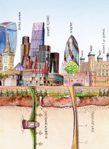
We featured Bridges of London earlier this week. However, the public realm relating to the Thames is more than the river itself and the bridges crossing it. One of London’s defining features, in recent times, as the Thames has cleaned and the spaces beside it have become less-traffic choked, is its riverside frontage. This lovely […]
Continue reading »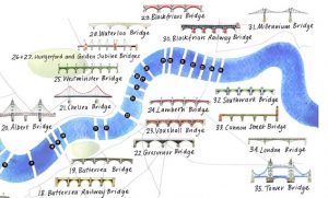
The River Thames is London’s defining geographical feature and its inclusion is almost mandatory on any map attempting to cover the whole of the capital. Bridges are most Londoners’ visible contact with the river, with over 30 spanning the river in London, including elevated crossing by the so-called “Underground”. As such, illustrated maps of the […]
Continue reading »
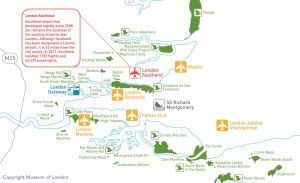
Londoners will be very familiar with the crowded London Underground services and their famous diagrammatic Tube Map, but might be less familiar with another public transport network – boats on the River Thames. Yes, you can commute to work by catamaran – as long as you live and work close to the river. London’s river […]
Continue reading »
The Shard, London’s tallest building, has a viewing platform at the top, the The View from the Shard. To access the platform, you use two lifts, the first from the 1st to the 33rd floor and then a second lift from the 33rd to 68th floor. The viewing galleries are then on the 69th floor […]
Continue reading »
Every year, for the last few years, Mapping London editors Oliver and James have been invited to create and submit an artwork for 10×10 London, a charity art auction organised by Article 25, the architectural development charity (originally called Architects for Aid). Being neither artists or architects, it is very flattering that we have been […]
Continue reading »
The London Thames Path is a brand new book by author/il […]
Continue reading »
We really like this simple borough-by-borough cartogram […]
Continue reading »Travelling around London is a little harder today. With […]
Continue reading »
The London Thames is a new poster – a small extra […]
Continue reading »