London Winter Run
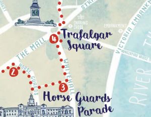
We love a good custom map for an event, and the London Winter Run has just one – and despite it pretending to be an
Continue reading »The latest outputs from researchers, alumni and friends at the UCL Centre for Advanced Spatial Analysis (CASA).

We love a good custom map for an event, and the London Winter Run has just one – and despite it pretending to be an
Continue reading »Easter is approaching and its time for some eggs to find – 120 two-foot high ones are in London right now thanks to the Elephant
Continue reading »It’s a frosty start to March, but green shoots are finally appearing in the ground. So it’s a great time to introduce a new book,
Continue reading »King’s Cross Central, the area behind King’s Cross and St Pancras stations, has launched a monster trail, which is running up to and including Hallowe’en
Continue reading »Kew is one of London’s leafy surburban neighbourhoods. Situated on a long curve of the River Thames, ot is of course famous for Kew Gardens,
Continue reading »We’ve long liked temporary “parade” sculpture trails in London – they make exploring a neighbourhood even more interesting, if around the corner is one of
Continue reading »To celebrate the opening of a Jurassic Park pop-up shop at the Natural History Museum in London this week (the popup is to mark 30
Continue reading »Following on from the colourful map of curry restaurants along the new Elizabeth line, Mapping London spotted this earlier map in the FT Globetrotter series,
Continue reading »As a complement to the Illuminated River map we featured previously, which shows the central London bridges that are lit up with LED-light-based visualisations, South
Continue reading »The Illuminated River is a long-term LED light installation on a number of bridges spanning the Thames in central London. At 9:30pm each night, various
Continue reading »The new map is the latest in a long line in attractively packaged, specialist maps from Blue Crow Media which highlight the locations of a single feature of London on a bepoke basemap and guide – be it notable trees, Brutalist buildings or in thi…
Continue reading »Central London has long been a spatial challenge for tourists and others unfamiliar with it. It’s very big, and most of it isn’t built on an easily understandable grid pattern. Quirks and kinks in streets built back in Roman times, persist …
Continue reading »Various central London locations are this week, as part of London Car Free Day (which is today!), stocking free copies of a paper map (you can also order a copy online) for walking routes in central London – it’s called Footways, and was fi…
Continue reading »The London Greenground Map, by designer Helen Ilus (Hi Design), takes its inspiration from the famous tube map to create a network of walking routes, with parks as “stations” in and around the capital. The map was first created a couple of …
Continue reading »After nearly a year and a half when much of London has been staying away from its central business district, there’s a big push to get people back into the middle of town. The Mayor of London and Visit London have this week launched Let’s D…
Continue reading »We’ve all had plenty of to explore our local areas, over the last year, with several lockdowns and other movement restrictions meaning that our local village, town or part of London is our exercise arena. With this in mind it’s always nice …
Continue reading »Blue Crow Media, long-time makers of bespoke themed maps of London and other places, have switched from their regular architecture focus and produced a lovely new map focusing on notable trees in the capital. There are around as many trees as people in…
Continue reading »“Bloody London” is a new book by author, illustrator cartographer David Fathers. Previously writing about the Thames Path in London, the Regents’ Canal and London’s “lost rivers“, David has for this book focused on a…
Continue reading »One of London’s hardest challenge, the Circle Line Pub Crawl, got even harder a few years ago when Transport for London reconfigured the line to have a “tail” extending down to Hammersmith. Now, there are 35 tube stations and correspo…
Continue reading »Following the original 2017 edition and a 2018 update, The East End Trades Guild have launched a new version of their specially created map of independent retail businesses in the East End of London, many of whom sell unique, locally made gifts ideal f…
Continue reading »This decorative map, simply called “Kew”, was produced by Herry Perry of Vincent Brooks lithographers in 1929. It was part of a series of posters commissioned for what is now Transport for London and actually depicts the area to the south o…
Continue reading »We featured a map showing London’s North Bank earlier in the summer – just in time for the peak holiday season, the rivals across the Thames now have a new map of their own! “South of the River” aims to map everything of tourist…
Continue reading »You know about London’s South Bank – the other side of the river has been looking on at envy at the pedestrian utopia over there and has created this guide and walking map to the “Northbank” – the area stretching from Traf…
Continue reading »This artistic map of a green walking route in central London was drawn by graphic designer Helen Ilus. By showing just the parks that are the focus of the walk, and not the rest of London’s hustle and bustle, it is an effective and attractive way…
Continue reading »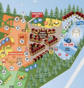
It’s been a wet and drab December so far – so why not escape the gloom and get into the spirit of the season with the biggest Christmas market/funfair in London? Winter Wonderland, which occupies a huge space at the eastern end of Hyde Park, stretching almost from Marble Arch to Hyde Park Corner. The […]
Continue reading »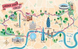
Urban Rambles is a new book by Nicholas Rudd-Jones, featuring walks through many of England’s cities. The book comes with a 22 route maps, drawn by illustrator Sara Mulvanny (see her portfolio page for the book), including a couple in London, which we feature here. Above is the “London Inner Circle” which stretches from Hyde […]
Continue reading »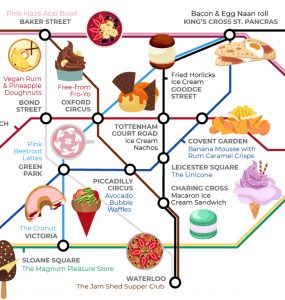
You’ve done the Circle Line Pub Crawl. Now try the Circle Line Food Crawl. Or use this special “Food Tube Map”, produced by Wren Kitchens (they write about it here), to visit unusual gastronomic experiences anywhere inside the Zone 1 area marked out by the Circle Line. The 25 restaurants and eateries included in this […]
Continue reading »TfL is keen to get people travelling on the tube when it’s not so busy, and also beyond Zone 1. With this in mind, they’ve commissioned these line maps, in conjunction with Time Out magazine. Each line (except the Waterloo and City) gets one, with the most interesting sections of each line converted into a […]
Continue reading »
Dry January? You might want to look away. From the industry’s official promoter of the fortified Andalusian wine in the UK, comes this map of tapas bars and restaurants in central London where you can be sure of finding a good glass of sherry. The map was published in October last year but we just […]
Continue reading »This rather nice diagrammatic map, created by by Premium Tours, looks at the top ranking on TripAdvisor for each cuisine type, for London, and then plots the restaurant concerned, in its approximate geographic location. Each restaurant is represented by a category icon, which varies according to the continent that the cuisine is based in. A […]
Continue reading »Songs of London Town replaces street names with song names. The pastel coloured, hand-drawn basemap is overlaid with hundreds of song titles, each arranged over the street that it references. It’s rather a clever idea and allows for the creation of your own song-narrated self-guided tour of each central London neighborhood you happen to be […]
Continue reading »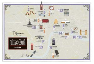
Time Out London, in conjunction with official Harry Potter portal Pottermore, created this lovely map showing 18 places in central London that have featured in the Harry Potter books and films. From Platform 9 3/4 at King’s Cross station, to the Knight Bus crossing Lambeth Bridge, the map allows you to construct your own Harry […]
Continue reading »

We do like arty tube maps here at Mapping London and Travelzoo have obliged with this rather pretty map of 50 free things to do in this summer in London, attaching the attractions to tube stations, with the key elaborating on the station names and walking distance to the place of interest. With London’s size […]
Continue reading »As London swelters a heatwave, people in search of a cooling waterside stroll might notice that London doesn’t apparently have many rivers. There is of course the mighty River Thames, and a few others here and there visible. But there are many more that you don’t just come across – they are just hidden underground. […]
Continue reading »
Londoners will be very familiar with the crowded London Underground services and their famous diagrammatic Tube Map, but might be less familiar with another public transport network – boats on the River Thames. Yes, you can commute to work by catamaran – as long as you live and work close to the river. London’s river […]
Continue reading »
From British Gas comes this lovely map of a walking trail in central London, that highlights many of the streets and locations that are still lit by gas lamps in London – it may come as a surprise to many people, but there are many gas lamps still in the oldest parts of London, lit […]
Continue reading »
Tower Hamlets council, one of the 32 London borough councils, has produced this simple pictorial map as part of a consultation for “Tower Hamlets 2031”, setting the “local plan” for urban realm policy for the next 15 years. The map appears on various advertising panels throughout the borough at the moment, and also appears on […]
Continue reading »
These attractive hand-drawn maps have been produced for a pocket guide “London’s Canals & Rivers” published by the Canal & River Trust by illustrator and cartographer Bek Cruddace. They show the navigable waterways around London, including the Thames and Lea Rivers and the Regent’s and Grand Union canals. The maps are designed for walkers and […]
Continue reading »
The Shard, London’s tallest building, has a viewing platform at the top, the The View from the Shard. To access the platform, you use two lifts, the first from the 1st to the 33rd floor and then a second lift from the 33rd to 68th floor. The viewing galleries are then on the 69th floor […]
Continue reading »