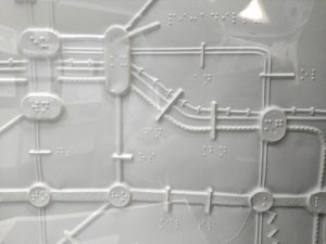
Kew

This decorative map, simply called “Kew”, was produced by Herry Perry of Vincent Brooks lithographers in 1929. It was part of a series of posters commissioned for what is now Transport for London and actually depicts the area to the south o…

Continue reading »

TfL’s Corporate Archives

The Corporate Archives division of Transport for London recently held a short internal exhibition at their headquarters at Palestra, called “Mapping London” and showcasing new and old maps of London’s transport from the archive. Amongst the highlights included this Lego historic tube map. The Lego is modern but the map was one of the last […]

Continue reading »

River Services Map

Londoners will be very familiar with the crowded London Underground services and their famous diagrammatic Tube Map, but might be less familiar with another public transport network – boats on the River Thames. Yes, you can commute to work by catamaran – as long as you live and work close to the river. London’s river […]

Continue reading »

TubeHeartbeat

tubeheartbeat2

TubeHeartbeat visualises one of Transport for London’s most interesting and detailed open dataset, RODS. This has data on the approximate weekday volume of passengers between each pair of stations on the network, and entering/exiting the stations, at 15-minute intervals. Mapping this, as TubeHeartbeat does, shows a distinctive pulse, or heartbeat, as commuters surge in and […]

Continue reading »

Steel Tube Map

stainlesssteel_tubemap1

The tube map is almost certainly London’s most widely produced and collected map, with many millions of the pocket version being issued for free every year by TfL from London’s 270+ tube stations. But how about having one that’s made of steel? Well, now you can thanks to Suck UK, who have produced an officially […]

Continue reading »

London Connections: A Geographic Tube Map

View the full map as a lovely vector PDF The Transport for London (TfL) tube map, with its straight lines, 45-degree rounded corners and simple, clear cartography, is a design classic. The map dispenses with other features such as parks, roads and urban extents – because you don’t need those if you are getting from […]

Continue reading »

A Week in the Life of London’s Public Transit System

I’ve been meaning to post this for ages but have had a great deal on my plate (more posts and visualisations to follow in the next week I hope) so this has kept slipping, together with the six or seven other ‘draft’ posts I’ve got going. Anyway, this visualisation shows average entries at each and every Underground, […]

Continue reading »

Just how far can the Tube take you?

Transport for London have just released their performance data (link here) for the London Underground network. It is in the form of a really detailed file that contains, amongst other things, the “Peak Operated Kilometres” and “Peak Passenger Journeys” for the past 6 years or so. If you total the distances covered by the Tube …

Continue reading »