

Category: london

Having a lunch at Duck and Waffle, Heron Tower in London
 |
| Looking at Heron Tower on the street (The image is taken by Networking City) |
Some days ago, I went to Heron Tower near Liverpool Street Station in London.
This 46 floors and 230meter remarkable high rise building,
which is designed by KPF with structure design by Arup, was built in 2011.
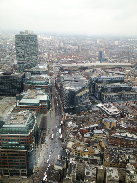
Duck & Waffle restaurant is located on the 40th floor of the building.
 |
| Looking down toward Liverpool Street (The image is taken by Networking City) |
 |
| The bar on the 40th floor of Heron tower (The image is taken by Networking City) |
 |
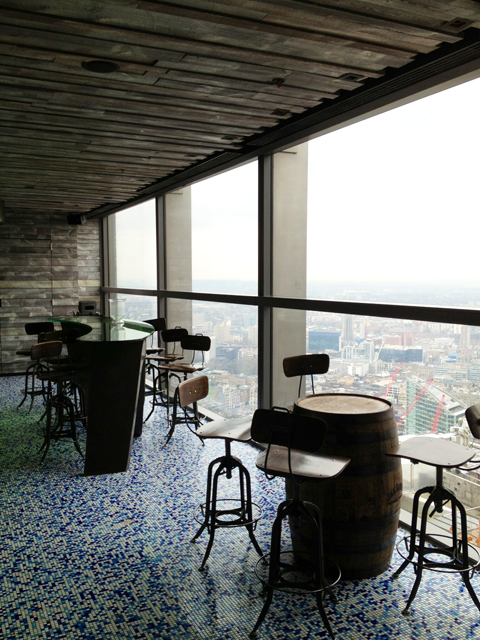
| The interior of Duck & Waffle (The image is taken by Networking City) |
 |
| The ‘Duck & Waffle’ at Duck & Waffle (The image is taken by Networking City) |
My friend recommended this place because I can see an incredible cityscape of London, although the menu is pricey.
Not only the beautiful scenery of London but unusual food, which is crispy fried duck and fried-egg covered a waffle with maple syrup, are there.
The interior design of the restaurant is not looking good as much as some photos on their website.
It feels like rather refined, but some materials such as yellow wave ceiling do not make a nice combination altogether.
However, looking down 30 St Mary Axe (or Gherkin) designed by Foster and 122 Leadenhall Street (or Cheese Grater) by Rogers just beside them was a strange and exciting experience. It gives a reason to go there.
 |
| Looking at 30 St Mary Axe and 122 Leadenhall Street (The image is taken by Networking City) |
I recorded a film image in a high-speed elevator of Heron Tower.
The feeling of coming down from the 40th floor to ground level by the elevator is similar to that of dreaming flying dim London air but immediately returning to desert reality.
Continue reading »

Having a lunch at Duck and Waffle, Heron Tower in London
|
| Looking at Heron Tower on the street (The image is taken by Networking City) |
Some days ago, I went to Heron Tower near Liverpool Street Station in London.
This 46 floors and 230meter remarkable high rise building,
which is designed by KPF with structure design by Arup, was built in 2011.
Duck & Waffle restaurant is located on the 40th floor of the building.
|
| Looking down toward Liverpool Street (The image is taken by Networking City) |
|
| The bar on the 40th floor of Heron tower (The image is taken by Networking City) |
|
| The interior of Duck & Waffle (The image is taken by Networking City) |
|
| The ‘Duck & Waffle’ at Duck & Waffle (The image is taken by Networking City) |
My friend recommended this place because I can see an incredible cityscape of London, although the menu is pricey.
Not only the beautiful scenery of London but unusual food, which is crispy fried duck and fried-egg covered a waffle with maple syrup, are there.
The interior design of the restaurant is not looking good as much as some photos on their website.
It feels like rather refined, but some materials such as yellow wave ceiling do not make a nice combination altogether.
However, looking down 30 St Mary Axe (or Gherkin) designed by Foster and 122 Leadenhall Street (or Cheese Grater) by Rogers just beside them was a strange and exciting experience. It gives a reason to go there.
|
| Looking at 30 St Mary Axe and 122 Leadenhall Street (The image is taken by Networking City) |
I recorded a film image in a high-speed elevator of Heron Tower.
The feeling of coming down from the 40th floor to ground level by the elevator is similar to that of dreaming flying dim London air but immediately returning to desert reality.
Continue reading »
Having a lunch at Duck and Waffle, Heron Tower in London
Looking at Heron Tower on the street (The image is taken by Networking City)Some days ago, I went to Heron Tower near Liverpool Street Station in London. This 46 floors and 230meter remarkable high rise building, which is designed by KPF with structure…
Continue reading »London’s Oyster Card Tidal Flow
Here is an animation I created a couple of years ago, one of a number I created for the “Sense and the City” exhibition at the London Transport Museum, which ran from Summer 2011 to Spring 2012. A version of this animation was branded appropriately for the exhibition and shown upstairs in the interactive section. […]
Continue reading »

BSP Seminar – Compact cities or garden suburbs?
 |
| Dr. Nicolas Falk presented for Bartlett School of Planning. Image is taken by Networking City |
In this year, Bartlett School of Planning run BSP seminar series over the semesters. On 6 March 2013, Dr. Nicolas Falk, Director of URBED (Urbanism Environment Design), provided a presentation the title of “Compact cities or garden suburbs?” at Central House of UCL.
Because I was bit late, I could not watch all his presentation. He suggested simple but well-summarised planning keywords and showed relevant examples over the European cities. For example, he argued there are five key elements to reach Smart Growth. The five keys can be represented as 5C: community, connectivity, character, climate and collaboration. And he mentioned the meaning of the community with examples such as ‘Schools as community hub with Houton, NL’ and ‘Places for all ages with Reiselfeld, Freiburg, Germany’.
Connected city, Five finger strategy and Redefining Greenbelt were mentioned as the future direction for smart growth in the UK as the conclusion of the lecture. In particular, he had expressed the negative feeling against current Greenbelt policy. According to him, the greenbelt of London is little bit old-fashioned and the greenbelt has been a strong obstacle to expand development areas and connecting between London and other cities. Although he said Redefining Greenbelt as one issue of the future direction, all three items should be accompanied with the reorganisation of London’s greenbelt.
During his lecture, some questions were emerging by myself. Is really Green belt the obstruction of smart growth? Is there smart growth? If possible, how are different process and method needed compared to typical urban development? How can it work in high density?
I think there are two reasons why the questions were come up.
In the first, he emphasised the term of ‘smart’ and ‘smarter’ several times in his lecture. However, the term, smart, has been considering with the development of technology in our built-environment while his suggestions and examples were more familiar with sustainable urban planning and design.
Secondly, the key issues what he argued are too abstract and vague. We know community, connectivity, character, climate and collaboration are crucial factors. People might want to listen from him how we can achieve those factors, what kind of process, the roles of stakeholders and so on.
 |
| One of his lecutre slide. Image is taken by Networking City |
There are good materials of urban design, field research and regional study on the homepage of URBED. They have run urban design and architectural design studios at University of Sheffield, so we can find the links of interesting students’ works. Also, they published ‘Sustainable Urban Neighbourhood’ in 2010 what includes some contents of today’s lecture.

BSP Seminar – Compact cities or garden suburbs?
|
| Dr. Nicolas Falk presented for Bartlett School of Planning. Image is taken by Networking City |
In this year, Bartlett School of Planning run BSP seminar series over the semesters. On 6 March 2013, Dr. Nicolas Falk, Director of URBED (Urbanism Environment Design), provided a presentation the title of “Compact cities or garden suburbs?” at Central House of UCL.
Because I was bit late, I could not watch all his presentation. He suggested simple but well-summarised planning keywords and showed relevant examples over the European cities. For example, he argued there are five key elements to reach Smart Growth. The five keys can be represented as 5C: community, connectivity, character, climate and collaboration. And he mentioned the meaning of the community with examples such as ‘Schools as community hub with Houton, NL’ and ‘Places for all ages with Reiselfeld, Freiburg, Germany’.
Connected city, Five finger strategy and Redefining Greenbelt were mentioned as the future direction for smart growth in the UK as the conclusion of the lecture. In particular, he had expressed the negative feeling against current Greenbelt policy. According to him, the greenbelt of London is little bit old-fashioned and the greenbelt has been a strong obstacle to expand development areas and connecting between London and other cities. Although he said Redefining Greenbelt as one issue of the future direction, all three items should be accompanied with the reorganisation of London’s greenbelt.
During his lecture, some questions were emerging by myself. Is really Green belt the obstruction of smart growth? Is there smart growth? If possible, how are different process and method needed compared to typical urban development? How can it work in high density?
I think there are two reasons why the questions were come up.
In the first, he emphasised the term of ‘smart’ and ‘smarter’ several times in his lecture. However, the term, smart, has been considering with the development of technology in our built-environment while his suggestions and examples were more familiar with sustainable urban planning and design.
Secondly, the key issues what he argued are too abstract and vague. We know community, connectivity, character, climate and collaboration are crucial factors. People might want to listen from him how we can achieve those factors, what kind of process, the roles of stakeholders and so on.
|
| One of his lecutre slide. Image is taken by Networking City |
There are good materials of urban design, field research and regional study on the homepage of URBED. They have run urban design and architectural design studios at University of Sheffield, so we can find the links of interesting students’ works. Also, they published ‘Sustainable Urban Neighbourhood’ in 2010 what includes some contents of today’s lecture.
BSP Seminar – Compact cities or garden suburbs?
Dr. Nicolas Falk presented for Bartlett School of Planning. Image is taken by Networking CityIn this year, Bartlett School of Planning run BSP seminar series over the semesters. On 6 March 2013, Dr. Nicolas Falk, Director of URBED (Urban…
Continue reading »
The London Bike Share Marches North
It’s not just Wandsworth and Fulham that will be getting Barclays Cycle Hire in the next year or so when Phase 3 goes live – Hackney and Islington will be getting a few too. The iconic “Boris Bikes” will be … Continue reading →
Continue reading »
London’s Oyster Card Flows
Here is an animation that Ollie O’Brien created a […]
Continue reading »
Me, Geolocated on Twitter
I was prompted by the excellent Twitter Tongues map, where geolocated tweets in London (including mine, and those from hundreds of thousands of others) were mined by Ed Manley over the summer, and then mapped by James Cheshire, to see … Continue reading →
Continue reading »World City Living and Working Densities: Poles Apart?
One of the most recognisable visualisation techniques used by LSE Cities in the Urban Age publications is the 3D density map- an intuitive and engaging way to represent built form, and enable comparison of very different city environments across the globe. I’ve been producing 3D density maps in my own research for around five years … Continue reading →![]()
Urban Age Electric City Conference
I recently began a new job at LSE Cities and have been working for the last month on materials for the Electric City conference in London, taking place on the 6th and 7th December this week. The conference will be exploring smart cities and disruptive urban tech from a sociological slant, and includes talks from … Continue reading →![]()

A Periodic Table for London
Here is a webpage that uses my own CityDashboard API*, to build a Periodic-Table inspired “data artwork” of live London information, as a series of coloured square panels on a website. The squares update regularly with fresh information, and throb … Continue reading →
Continue reading »
Identifying Communities in Traffic Flow
Edit: See new Central London image below! One recent bit of research I have been working on has been looking at the application of community detection algorithms to traffic flow in London. The idea is that within the traffic system exist a number …
Read more →

Update to CityDashboard CSV API & iPad Wall!
I’ve made some minor alterations to the CSV API for CityDashboard. The main changes are in the metadata rows (the top two) rather than the subsequent rows. Specifically, the top metadata row has now split out the description, source and … Continue reading →
Continue reading »

The Electric Tube
In six weeks time, London will have a second orbital railway. The Circle Line has been running for just over 100 years, and on 9 December will be joined by the latest addition to Transport for London (TfL)’s Overground network … Continue reading →
Continue reading »
Detecting Languages in London’s Twittersphere
Over the last couple of weeks, and as a bit of a distraction from finishing off my PhD, I’ve been working with James Cheshire looking at the use of different languages within my aforementioned dataset of London tweets. I’ve been handling the data …
Read more →
Mapped: Twitter Languages in London
**Update: You can see a new fully-interactive ve […]
Continue reading »
Prism: A Real-life CityDashboard
I was at the V&A earlier today to see Prism, a new installation by digital artist Keiichi Matsuda which is part of the London Design Festival. Prism uses data from UCL CASA’s CityDashboard and other London open data sources, to … Continue reading →
Continue reading »
Mapping London Presentation for the Society of Cartographers Conference
I presented on the Mapping London blog, at the Society of Cartographers’ 48th Annual Conference which was at UCL this year, showing a general outline of the blogs and some maps featured on it, plus some work done by James … Continue reading →
Continue reading »
Evelyn Grace Academy by Zaha Hadid Architects – Alternative way to consider the future of our school
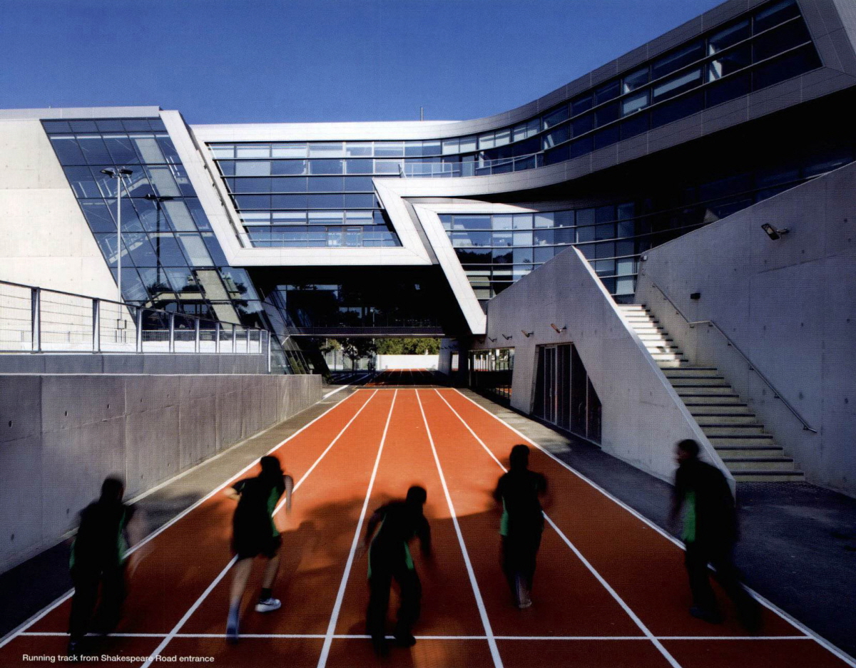
Image is taken from Zaha Hadid Architects / The main entrance of Evelyn Grace Academy
Last September, during Open City event in London, Evelyn Grace Academy in Brixton was included in the list of the event and it was a nice opportunity to visit recent Zaha’s work. Hundreds of people came to the school and agreed it is an unusual architecture and special experience. After the visiting, it was thought that writing an article about Evelyn Grace Academy would be worth to understand new trend of education buildings in UK and Zaha’s approach for the type of architecture. Therefore, when Korean Institute of Educational Facilities asked to contribute an article about recent UK education building, it was easy to decide topic of the article.
Through the article, there are three main arguments to look deeply at Evelyn Grace Academy. Firstly, from the point of urban policy, this building should be understood as a flagship project in a devastated urban area and as an education led urban regeneration. ARK Schools, an education charity and the founder of the school, believes that education is an important method to cut the cycle of poverty. This charity supports to increase education quality in impoverished areas and has set up 11 schools in UK. Evelyn Grace Academy has been planned for not only a stunning shape of architecture in old affordable housing areas but also finding a possibility to overcome poverty and inequality in Brixton that had no secondary school.
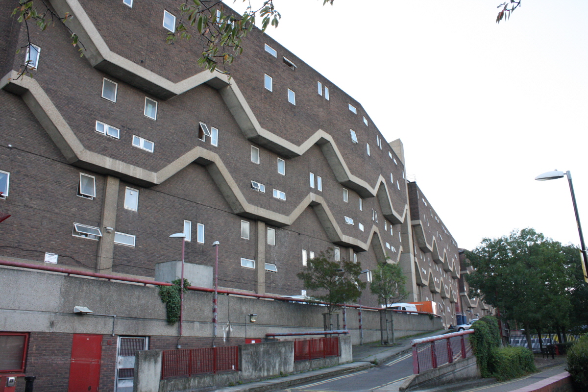
Image by Networking City / Social housing in Brixton
Secondly, as considering the internal relationships, this school needs to be examined as a small society, furthermore, as a city. Although school (especially university) generally has been understood as a city because lots of students and staffs stay in, Evelyn Grace Academy which has four schools in the building is much more complex and complicate than other schools. Definitely, there should be more delicate considerations to make discreet management system and adequate collaboration between the schools from the early stage of the building design. As a result of the considerations, the corridors of this building, wider than normal school corridors, play a role like streets in small town by variation of visual effects, diverse volumes of internal space and good connection with internal and external space, and it leads more social activities of students.

Image by Networking City / Inside corridor of Evelyn Grace Academy

Image by Networking City / Spatial Experience in Evelyn Grace Academy
Lastly, Evelyn Grace Academy is a good example to show how architects fight against the common ideas of ‘school’, one of the most quantificational and standardized architectural type, within limited budget and area with keeping their design ideas and its final quality. There are many regulations and basic standards for the school building like suitable class size, noise and so on. The architects had have to consider how dynamic form and space make a cool relationship with standardized room size, basic class unit and needed clear functionality. Z shape of Evelyn Grace Academy, which is very unusual among school projects, was suggested for complex programs and effective using the site rather than Zaha’s design tendency. (Interview with Lars Teichmann, Project Architect) Architects generally do not want to make Z shape because it is hard to solve functional problems in the plan even though it is a private house. But in this project, Z shape of the building makes a clear distinctive point in contrast to other school projects and the herald symbol showing the change of the most deprived area in the UK.

Image is taken from Zaha Hadid Architects / Site circulation and Composition
Some people have a cynical view for Zaha’s works. I was one of them.
However, after visiting Evelyn Grace Academy, when her project is seen on website or magazine, the project attracts me more than before.

Evelyn Grace Academy by Zaha Hadid Architects – Alternative way to consider the future of our school
Image is taken from Zaha Hadid Architects / The main entrance of Evelyn Grace Academy
Last September, during Open City event in London, Evelyn Grace Academy in Brixton was included in the list of the event and it was a nice opportunity to visit recent Zaha’s work. Hundreds of people came to the school and agreed it is an unusual architecture and special experience. After the visiting, it was thought that writing an article about Evelyn Grace Academy would be worth to understand new trend of education buildings in UK and Zaha’s approach for the type of architecture. Therefore, when Korean Institute of Educational Facilities asked to contribute an article about recent UK education building, it was easy to decide topic of the article.
Through the article, there are three main arguments to look deeply at Evelyn Grace Academy. Firstly, from the point of urban policy, this building should be understood as a flagship project in a devastated urban area and as an education led urban regeneration. ARK Schools, an education charity and the founder of the school, believes that education is an important method to cut the cycle of poverty. This charity supports to increase education quality in impoverished areas and has set up 11 schools in UK. Evelyn Grace Academy has been planned for not only a stunning shape of architecture in old affordable housing areas but also finding a possibility to overcome poverty and inequality in Brixton that had no secondary school.
Image by Networking City / Social housing in Brixton
Secondly, as considering the internal relationships, this school needs to be examined as a small society, furthermore, as a city. Although school (especially university) generally has been understood as a city because lots of students and staffs stay in, Evelyn Grace Academy which has four schools in the building is much more complex and complicate than other schools. Definitely, there should be more delicate considerations to make discreet management system and adequate collaboration between the schools from the early stage of the building design. As a result of the considerations, the corridors of this building, wider than normal school corridors, play a role like streets in small town by variation of visual effects, diverse volumes of internal space and good connection with internal and external space, and it leads more social activities of students.
Image by Networking City / Inside corridor of Evelyn Grace Academy
Image by Networking City / Spatial Experience in Evelyn Grace Academy
Lastly, Evelyn Grace Academy is a good example to show how architects fight against the common ideas of ‘school’, one of the most quantificational and standardized architectural type, within limited budget and area with keeping their design ideas and its final quality. There are many regulations and basic standards for the school building like suitable class size, noise and so on. The architects had have to consider how dynamic form and space make a cool relationship with standardized room size, basic class unit and needed clear functionality. Z shape of Evelyn Grace Academy, which is very unusual among school projects, was suggested for complex programs and effective using the site rather than Zaha’s design tendency. (Interview with Lars Teichmann, Project Architect) Architects generally do not want to make Z shape because it is hard to solve functional problems in the plan even though it is a private house. But in this project, Z shape of the building makes a clear distinctive point in contrast to other school projects and the herald symbol showing the change of the most deprived area in the UK.
Image is taken from Zaha Hadid Architects / Site circulation and Composition
Some people have a cynical view for Zaha’s works. I was one of them.
However, after visiting Evelyn Grace Academy, when her project is seen on website or magazine, the project attracts me more than before.

Olympic Venue Tweets on CityDashboard
There’s a new, temporary panel on the London CityDashboard which shows Twitter activity at the London 2012 venues. The panel is using data from new Twitter collector tools in the Big Data Toolkit, which being developed by my colleague Steven James Gray as part of his PhD. For each venue, the collectors count the number […]
Continue reading »
London 2012: Using Fear to Tame Transportation Demand
One of the biggest advantages, I feel, about studying urban transport phenomena in London is the simple ability to be able look out of the window and see what is actually going on. This week, the Olympics and its (supposed) transportation chaos, c…
Read more →
Lives on the Line: Life Expectancy and Child Poverty as a Tube Map
Maps have always been a powerful way of highlighting L […]
Continue reading »
London 2001 to 2011: The differences between Male and Female population change
Below are maps showing how the population change in London between 2001 and 2011 differs depending on the age range and gender. Swipe across each image to see how the male and female population change differs across London’s Boroughs. Here…
Continue reading »
2001 to 2011 Population Change in London
Following on from my previous post I thought I would look at London in some more detail. In the ten years between 2001 and 2011 every borough’s population has increased – with the exception of Kensington and Chelsea. The breakdowns…
Continue reading »
2001 to 2011 Population Change in England and Wales
Today (16th July) at 11am the Office for National Statistics (ONS) released the first results from the 2011 Census in England and Wales. This included population data at the local authority level, rounded to the nearest hundred in 5 year…
Continue reading »A Tale of Tech City: the future of Inner East London’s Digital Economy
Earlier this month Demos published a fascinating report on the hot topic of London’s “Tech City” cluster, which has been promoted by the government as a key growth pole for the UK. The report authors Max Nathan, Emma Vandore and Rob Whitehead, put the Inner East London cluster in the context of similar phenomena in … Continue reading »![]()
In Praise of Paper Maps
When was the last time you held a paper map? I don̵ […]
Continue reading »2007 fps – A London Conversation for the BFI SouthBank
The 37 minute film below by D-Fuse and Illustrious Company has been commissioned to make a new immersive visual and sound installation, to be presented as part of the opening of the revitalised and refurbished National Film Theatre, BFI Southbank. Desi…
Continue reading »2007 fps – A London Conversation for the BFI SouthBank
The 37 minute film below by D-Fuse and Illustrious Company has been commissioned to make a new immersive visual and sound installation, to be presented as part of the opening of the revitalised and refurbished National Film Theatre, BFI Southbank. Designed as a large scale piece of public art, the work will be projected onto […]
Continue reading »The Diamond Jubilee in London: A Tweet Location Analysis
I’ve been collecting Twitter data for a little while now, and have managed to identify some interesting (if slightly frivolous) trends. But, when considering the wider applications of such a dataset, one question that has continued to bug me is – …
Read more →
BBC London Calling Season
To mark the Olympic year a series of programs on London is being broadcast…
Continue reading »Mapping Intra-metropolitan Journey-to-work Sustainability
As cities expand with multiple centres spread over massive regional hinterlands, the need to better…
Continue reading »Sponsored Space
Cities have always been the great spaces of commerce, trade and advertising; and recent decades…
Continue reading »