Special Issue on Smart Buildings and Cities for IEEE Pervasive Computing
Submission deadline: 1 July 2016 Extended to July 18th, 2016
Publication date: April–June 2017
One of Mark Weiser’s first envisionments of ubiquitous and pervasive computing had the smart home as its central core. Since then, researchers focused on realizing this vision have built out from the smart home to the smart city. Such environments aim to improve the transparency of information and the quality of life through access to smarter and more appropriate services.
Despite efforts to build these environments, there are still many unanswered questions: What does it mean to make a building or a city “smart”? What infrastructure is necessary to support smart environments? What is the return on investment of a smart environment?
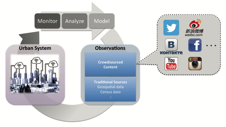
The key to building smart environments is the fusion of multiple technologies including sensing, advanced networks, the Internet of Things, cloud computing, big data analytics, and mobile devices. This special issue aims to explore new technologies, methodologies, case studies, and applications related to smart buildings and cities. Contributions may come from diverse fields such as distributed systems, HCI, ambient intelligence, architecture, transportation and urban planning, policy development, and cyber-physical systems. Relevant topics for issue include
- Applications, evaluations, or case studies of smart buildings/cities
- Architectures and systems software to support smart environments
- Big data analytics for monitoring and managing smart environments
- Economic models for smart buildings/cities
- Models for user interaction in smart environments
- Formative studies regarding the design, use, and acceptance of smart services
- Configuration and management of smart environments
- Embedded, mobile ,and crowd sensing approaches
- Cloud computing for smart environments
- Domain-specific investigations (such as transportation or healthcare)
The guest editors invite original and high-quality submissions addressing all aspects of this field, as long as the connection to the focus topic is clear and emphasized.
Guest Editors
Submission Information
Continue reading »