FW: Population Geography assistance, please

TweetFrom Mr Hubert Taylor – please reply to him, not to me… I will be grateful if your Population Geography or other colleagues are able to assist me please. Enquiry purpose The purpose of my enquiry is to seek informed support to identify in recognised terms, the geographical sub-regions of the vast multiple-race region Eurocentric […]

Continue reading »

GeoHCI 2013 – Geography meet Human-Computer Interaction

CHI (Computer-Human Interaction) is the premier conference in the calendar of Human-Computer Interaction (HCI) studies. While the first paper that deal with geographic technologies within this conference was presented in 1991 (it was about User Interfaces for Geographic Information Systems by Andrew Frank and presented at a special interest group meeting), geography did not received much attention […]

Continue reading »

Urban Ball – CityEngine, Unity and Agent Based Modelling on the iPad

CityEngine combined with Unity and a tablet – iOS requires a developers account, Android simple needs the 30 days Unity trial – allows city wide models to run with a touch based interface. We have used our recent work on Unity and Agent Based modelling to create a simple app…

Continue reading »

Augmented Reality City Table Top – Unity, CityEngine and Vufoira

The Vuforia AR Extension for Unity allows developers to build AR apps using the cross-platform game engine – Unity. Working with both the free and pro versions of Unity, Vuforia is not only free it is also one of the best out there in terms of tracking and image based tagging. Running…

Continue reading »

The iPad Video Wall

I am happy to report that the iPad Video wall has grown up from a prototype to a fully fledged finished project. If you have been following the blog then you would have saw the prototype video of the wall’s proof of concept and watched a single movie playing over all 8 iPads. Well I’ve […]

Continue reading »

Shortest Path Modelling and NavMesh in Unity and CityEngine

Shortest path network analysis, pedestrian modelling and moving agents around complex city scenes has always been a specialised domain. As regular readers will know we have always taken the view that game engines are arguably better suited to agent based modelling – especially in terms of pedestrian and transport than…

Continue reading »

Big Data Masochists must resist the Dominatrix of Social Theory

Here at the AAG in Los Angeles it has been good to witness at first hand the continued vibrancy and diversity of geographical inquiry.  In particular, themes such as Agent-based Modelling, Population Dynamics, and CyberGIS have been well represented alongside sessions on Social Theory, Gender and Cultural and Political Ecology.  At Friday’s sessions on big …
Read more

Continue reading »

Stickcrowd modelling

Commuting by train (if you’re lucky enough to get a seat) offers all sorts of opportunities for frivolous coding adventures (code-mmuting?). Having watched Andy Hudson-Smith’s review of Softimage crowd simulation.. … I decided to see how quick it would be (2 hours) to do something similar with stickmen, and at the same time develop a […]

Continue reading »

Flying Cities

Flying Cities is a concept animation by Stefan Haberkorn – it is one of the best uses of Lumion we have seen so far. It goes beyond the normal architectural visualisation and makes good use of landscaping and volumetric clouds. The full movie below sets the standard: Head over to http://www.vi-3d.de/ to see more examples of Stefans…

Continue reading »

GeoSocial Gauge

Over the last couple of months we have been working on getting our GeoSocial Gauge system up and running. The idea behind the website is to bring together social media and geographical analysis to monitor and explore people’s views, reactions, and interactions through space and time. It takes advantage of the emergence of social media to observe the human landscape as the living, breathing organism that it is: we can witness the explosion-like dissemination of information within a society, or the clusters of individuals who share common opinions or attitudes, and map the locations of these clusters. This is an unprecedented development that broadens drastically our understanding of the way that people act, react to events, and interact with each other and with their environment. We refer to this novel approach to study the integration of geography and society as GeoSocial Analysis.
The GeoSocial Gauge has several live streams ranging from exploring the political issues (e.g. Sequester) to to see what people are tweeting about TV (The Walking Dead).

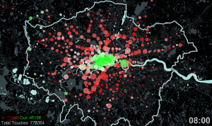
Screen shot of GeoSocial Gauge of the Sequester. Showing the location of tweets, the most frequent words and whether or not the messages are positive (green) or negative (red).
Screen shot of GeoSocial Gauge of The Walking Dead.

Some of our initial work on this type of analyis can be found at:

  • Stefanidis, T., Crooks, A.T. and Radzikowski, J. (2013), Harvesting Ambient Geospatial Information from Social Media Feeds, GeoJournal, 78, (2): 319-338.
  • Crooks, A.T., Croitoru, A., Stefanidis, A. and Radzikowski, J. (2013), #Earthquake: Twitter as a Distributed Sensor System, Transactions in GIS, 17(1): 124-147.

Continue reading »
1 2