GRIT: ‘geospatial restructuring of industrial trade’

Alison Heppenstall, Gordon Mitchell, Malcolm Sawyer (LUBS) and I have been awarded an 18 month grant by the ESRC through their secondary data analysis initiative. Titled ‘Geospatial Restructuring of Industrial Trade’ (GRIT), the motivation for the grant came from a deceptively simple question: what happens to the spatial economy when the costs of moving goods …
Read more

Continue reading »

Call for Abstracts – 7th International Conference on Population Geographies, Groningen, The Netherlands, 25-28 June 2013

TweetCall for Abstracts now open! 7th International Conference on Population Geographies, Groningen, The Netherlands, 25-28 June 2013 The Call for Abstracts for the 7th International Conference on Population Geographies is now open! We welcome papers from all fields of population geographies. In particular, we welcome papers for the special sessions on the following topics (more […]

Continue reading »

The Alpine Population Conference

TweetAlp-Pop brings together scholars interested in population issues across several disciplines, among them demography, economics, and sociology. The conference emphasizes empirical rigor and innovation over a given topic or geographical area, and meets the challenges of interdisciplinary and international audiences. Submissions are particularly welcome on topics concerning: • population, families, and the welfare state • […]

Continue reading »

Research – The Study of Housing Renewal for Neighbourhood Regeneration in Ansan

Image by Networking City/ Cover page of the research paper


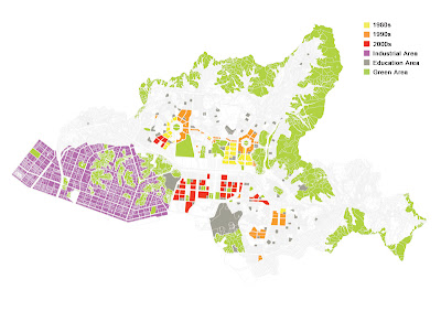
After 6 months efforts, the research paper ‘The Study of Housing Renewal for Neighbourhood Regeneration in Ansan’ was submitted to Centre for Creating Livable Village in Ansan, one of famous local NGO in South Korea, by this blog. The aim of the research is to understand the history of urban development of Ansan, a satellite city of Seoul, to identify the city’s characteristics by comparison with other cities in Korea, to investigate the present conditions of four low-rise housing areas through a field research and provide a planning guideline of neighbourhood regeneration for the NGO and the city government.
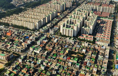
Image is taken from Naver/ The collision between high-rise apartments and low-rise housings


Ansan is a city in Gyeonggi Province, South Korea and a part of the Seoul Metropolitan Area. Originally, it was a small town on the coast of Yellow Sea until 1960’s. In 1970’s, Korean national government decided to develop it for the industrial city that contained small polluted factories. The small town was rapidly changed its shape as the first modern designed city (it means grid system) in Korea and lots of people have moved to the city for jobs and economic benefits since 1980’s.


At one time, Ansan was a symbol of successful economic achievement of Korea, however, now the city is facing a hard time that the numbers of closed factory are increasing and inextricable social problems related to the declining industry such as unstable employment, low income family, high residential mobility, poor residential environment and weak community networks.

Even though many researchers have been interested in this city, there was no challenge to clarify the relationship between the urban development process of Ansan and its impact on the change of residential areas. Also, there is no appropriate strategy to reorganize old, high dense, low-rise housing areas that the residents cannot support money for the redevelopment by high-rise apartments which has been the main development tool in Korea.
 
 
Image by Networking City/ The area and population of five cities


Image by Networking City/ The population structures of five cities


Therefore, Centre for Creating Livable Village, an independent organization for improving environment of residential areas based on local governments’ support, as a leading local NGO, set up a plan with young researchers to foster practical framework and in-detail analysis rather than grandiloquent words. The research paper is the first outcome of the plan.
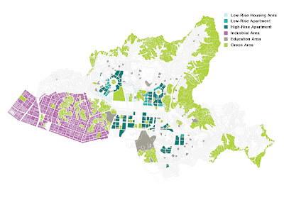
 

Image by Networking City/ The diagram of urban programme in Ansan


Image by Networking City/ The diagram of housing development process in Ansan


The research is composed of six chapters; Introduction, The characteristics of urban development and the change of housing areas in Ansan, The comparative analysis of urban characteristics between Ansan and four neighbour cities, The case study of four low-rise housing areas in Ansan, The strategy for neighbourhood regeneration and Conclusion.
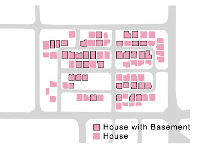
Image by Networking City/ The diagram of house that people live in basement in Bono-dong (One of low-rise housing area in Ansan)


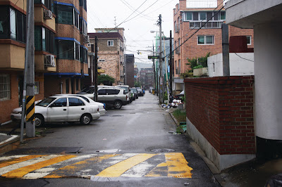
Image by Networking City/ The street view of Seonbu-dong (One of low-rise housing area in Ansan)

 
It will be used as a policy reference for the NGO and the Ansan city government, and hope it could be a tangible steppingstone for the future regeneration plan of the city.


Continue reading »

Research – The Study of Housing Renewal for Neighbourhood Regeneration in Ansan

Image by Networking City/ Cover page of the research paper


After 6 months efforts, the research paper ‘The Study of Housing Renewal for Neighbourhood Regeneration in Ansan’ was submitted to Centre for Creating Livable Village in Ansan, one of famous local NGO in South Korea, by this blog. The aim of the research is to understand the history of urban development of Ansan, a satellite city of Seoul, to identify the city’s characteristics by comparison with other cities in Korea, to investigate the present conditions of four low-rise housing areas through a field research and provide a planning guideline of neighbourhood regeneration for the NGO and the city government.
Image is taken from Naver/ The collision between high-rise apartments and low-rise housings


Ansan is a city in Gyeonggi Province, South Korea and a part of the Seoul Metropolitan Area. Originally, it was a small town on the coast of Yellow Sea until 1960’s. In 1970’s, Korean national government decided to develop it for the industrial city that contained small polluted factories. The small town was rapidly changed its shape as the first modern designed city (it means grid system) in Korea and lots of people have moved to the city for jobs and economic benefits since 1980’s.


At one time, Ansan was a symbol of successful economic achievement of Korea, however, now the city is facing a hard time that the numbers of closed factory are increasing and inextricable social problems related to the declining industry such as unstable employment, low income family, high residential mobility, poor residential environment and weak community networks.

Even though many researchers have been interested in this city, there was no challenge to clarify the relationship between the urban development process of Ansan and its impact on the change of residential areas. Also, there is no appropriate strategy to reorganize old, high dense, low-rise housing areas that the residents cannot support money for the redevelopment by high-rise apartments which has been the main development tool in Korea.
 
 
Image by Networking City/ The area and population of five cities


Image by Networking City/ The population structures of five cities


Therefore, Centre for Creating Livable Village, an independent organization for improving environment of residential areas based on local governments’ support, as a leading local NGO, set up a plan with young researchers to foster practical framework and in-detail analysis rather than grandiloquent words. The research paper is the first outcome of the plan.


Image by Networking City/ The diagram of urban programme in Ansan


Image by Networking City/ The diagram of housing development process in Ansan


The research is composed of six chapters; Introduction, The characteristics of urban development and the change of housing areas in Ansan, The comparative analysis of urban characteristics between Ansan and four neighbour cities, The case study of four low-rise housing areas in Ansan, The strategy for neighbourhood regeneration and Conclusion.

Image by Networking City/ The diagram of house that people live in basement in Bono-dong (One of low-rise housing area in Ansan)


Image by Networking City/ The street view of Seonbu-dong (One of low-rise housing area in Ansan)

 
It will be used as a policy reference for the NGO and the Ansan city government, and hope it could be a tangible steppingstone for the future regeneration plan of the city.


Continue reading »

Transactions of the Institute of British Geographers vritual issue on GIScience

Since early 2010, I had the privilege of being a member of the editorial board of the journal Transactions of the Institute of British Geographers . It is a fascinating position, as the journal covers a wide range of topics in geography, and is also recognised as one of the top journals in the field […]

Continue reading »

New paper: Agent-based modeling for community resource management: Acequia-based agriculture

We have just got a paper accepted in Computers, Environment and Urban Systems entitled “Agent-based modeling for community resource management: Acequia-based agriculture.” In the paper we explore the complex social interactions of water management, which involves landowners collectively maintaining and managing ditches which distribute water among the properties.

This system of the physical ditches and the maintaining organization together is known as an acequia, and the landowners who maintain it are called Parciantes. Acequias are interesting to researchers because of the developed common property regimes they require to function. The water carried by the ditches is a shared resource, and the complex management system of the acequia has evolved to avoid Hardin’s tragedy of the commons with regard to natural resources in the sense that it prevents the resource from being overused or under-maintained to the detriment of everyone. Ostrom has extensively studied the process of sharing such resources, investigating the structures set in place to preserve them. In ‘‘Governing the Commons’’, her book on common pool resources and human–ecosystem interactions, she suggests a set of characteristics that define stable communal social mechanisms. These characteristics include the presence of environment-appropriate rules governing the use of collective goods and the efficacy of individuals in the system.

Below is the abstract from the paper:

Water management is a major concern across the world. From northern China to the Middle East to Africa to the United States, growing populations can stress local water resources as they demand more water for both direct consumption and agriculture. Irrigation based agriculture draws especially heavily on these resources and usually cannot survive without them; however, irrigation systems must be maintained, a task individual agriculturalists cannot bear alone. We have constructed an agent-based model to investigate the significant interaction and cumulative impact of the physical water system, local social and institutional structures which regulate water use, and the real estate market on the sustainability of traditional farming as a lifestyle in the northern New Mexico area. The regional term for the coupled social organization and physical system of irrigation is ‘‘acequias’’. The results of the model show that depending on the future patterns of weather and government regulations, acequia-based farming may continue at near current rates, shrink significantly but continue to exist, or disappear altogether.
In the figure below we show some of our efforts in verification of the model, specifically, the water network, after 100 years of regular maintenance (A) and after 100 years of no maintenance (B). The darker the line, the more clear the segment is of sedimentation; only unmaintained acequias are impacted by sedimentation in this model, and appear in lighter shades.

Below is a movie are a few sample model runs showing how different scenarios play out, specifically with respect to land-use change.

Full reference:

Wise, S. and Crooks, A. T. (2012), Agent Based Modelling and GIS for Community Resource Management: Acequia-based Agriculture, Computers, Environment and Urban Systems. Doi http://dx.doi.org/10.1016/j.compenvurbsys.2012.08.004.
Continue reading »

New paper: Agent-based modeling for community resource management: Acequia-based agriculture

We have just got a paper accepted in Computers, Environment and Urban Systems entitled “Agent-based modeling for community resource management: Acequia-based agriculture.” In the paper we explore the complex social interactions of water management, which involves landowners collectively maintaining and managing ditches which distribute water among the properties.

This system of the physical ditches and the maintaining organization together is known as an acequia, and the landowners who maintain it are called Parciantes. Acequias are interesting to researchers because of the developed common property regimes they require to function. The water carried by the ditches is a shared resource, and the complex management system of the acequia has evolved to avoid Hardin’s tragedy of the commons with regard to natural resources in the sense that it prevents the resource from being overused or under-maintained to the detriment of everyone. Ostrom has extensively studied the process of sharing such resources, investigating the structures set in place to preserve them. In ‘‘Governing the Commons’’, her book on common pool resources and human–ecosystem interactions, she suggests a set of characteristics that define stable communal social mechanisms. These characteristics include the presence of environment-appropriate rules governing the use of collective goods and the efficacy of individuals in the system.

Below is the abstract from the paper:

Water management is a major concern across the world. From northern China to the Middle East to Africa to the United States, growing populations can stress local water resources as they demand more water for both direct consumption and agriculture. Irrigation based agriculture draws especially heavily on these resources and usually cannot survive without them; however, irrigation systems must be maintained, a task individual agriculturalists cannot bear alone. We have constructed an agent-based model to investigate the significant interaction and cumulative impact of the physical water system, local social and institutional structures which regulate water use, and the real estate market on the sustainability of traditional farming as a lifestyle in the northern New Mexico area. The regional term for the coupled social organization and physical system of irrigation is ‘‘acequias’’. The results of the model show that depending on the future patterns of weather and government regulations, acequia-based farming may continue at near current rates, shrink significantly but continue to exist, or disappear altogether.
In the figure below we show some of our efforts in verification of the model, specifically, the water network, after 100 years of regular maintenance (A) and after 100 years of no maintenance (B). The darker the line, the more clear the segment is of sedimentation; only unmaintained acequias are impacted by sedimentation in this model, and appear in lighter shades.

Below is a movie are a few sample model runs showing how different scenarios play out, specifically with respect to land-use change.

Full reference:

Wise, S. and Crooks, A. T. (2012), Agent Based Modelling and GIS for Community Resource Management: Acequia-based Agriculture, Computers, Environment and Urban Systems. Doi http://dx.doi.org/10.1016/j.compenvurbsys.2012.08.004.
Continue reading »

Wolfram Alpha’s Personal Analytics

Wolfram Alpha has just launched their new take on social media analysis, building personalised reports for Facebook users. The computational engine builds various metrics and visualisation based on usage over a period of time, number of friends, geographical distribution of friends and even a network graph showing connections between friends. If you head to the […]

Continue reading »