The Progress 1000: London’s most influential people 2016 – Mathematics – Evening Standard
The Progress 1000: London’s most influential people 2016 – Mathematics Evening Standard
Continue reading »The latest outputs from researchers, alumni and friends at the UCL Centre for Advanced Spatial Analysis (CASA).

The Progress 1000: London’s most influential people 2016 – Mathematics Evening Standard
Continue reading »The Progress 1000: London’s most influential people 2016 – Mathematics Evening Standard
Continue reading »Clarín.com |
Sin fallas en la primera cita con el detector portátil de emociones
Clarín.com Hasta la novela de Philip K. Dick y la película de Ridley Scott, este detector de emociones era sólo una máquina de ficción; hoy en día, el equipo de investigadores a cargo del proyecto, que incluye a expertos del Centre for Advanced Spatial Analysis … |
Mapping London editors James and Ollie were invited earlier this year to create a drawing for the 10×10 charity auction taking place later this week in London. The auction is organised by Article 25, an architectural charity (we took part last year too) and each invited artist is assigned a grid square somewhere in central […]
Continue reading »Every year, for the last few years, Mapping London editors Oliver and James have been invited to create and submit an artwork for 10×10 London, a charity art auction organised by Article 25, the architectural development charity (originally called Architects for Aid). Being neither artists or architects, it is very flattering that we have been […]
Continue reading »*Cross-posted from London: The Information Capital’s website* London’s maps are special. They were drawn by pioneers such as Charles Booth, who revealed the full extent of the city’s poverty, Jon Snow, who deployed maps to determine the cause of cholera, and Phyllis Pearsall, who mapped 23,000 streets in her hugely popular ‘A to Z’ guide. […]
Continue reading »
*Cross-posted from London: The Information Capital’s website* Whenever I teach an R class, I usually start by saying how the software is now used by the likes of The New York Times graphics department or Facebook to manipulate their data and produce great visualisations. However, I have always struggled to give tangible examples of how […]
Continue reading »*Cross-posted from London: The Information Capital’s website* As London: The Information Capital enters its second year in print, we think its maps and graphics continue to show London at its best. Here are 12 of our favourites… 12. Photogenic Features A sleepy tiger, a blue whale, the Queen’s Guards and the arc of the London Eye. To get […]
Continue reading »Evening Standard |
Meet London’s mathletes: from Aum Amin to Hannah Fry
Evening Standard A lecturer in the mathematics of cities at UCL’s Centre for Advanced Spatial Analysis, Fry has even applied maths to that seemingly illogical subject: the search for love. Understanding statistics, Fry says, shows us we should ditch our dating checklists. |
Evening Standard |
Meet London’s mathletes: from Aum Amin to Hannah Fry
Evening Standard A lecturer in the mathematics of cities at UCL’s Centre for Advanced Spatial Analysis, Fry has even applied maths to that seemingly illogical subject: the search for love. Understanding statistics, Fry says, shows us we should ditch our dating checklists. |
Meet London’s mathletes: from Aum Amin to Hannah Fry | London Evening Standard Evening Standard
Continue reading »Meet London’s mathletes: from Aum Amin to Hannah Fry Evening Standard
Continue reading »Meet London’s mathletes: from Aum Amin to Hannah Fry Evening StandardLondon is doing its sums. The capital has long been a magnet for great maths minds but the subject also underpins many of our industries here, from finance …
Continue reading »Meet London’s mathletes: from Aum Amin to Hannah Fry Evening Standard
Continue reading »
Like its English counterpart IMD, SIMD is released every few years by the Scottish government, as a dataset which scores and ranks every small statistical area in Scotland according to a number of measures. These are then combined to form an overall rank and measure of deprivation for the area. This can then be mapped … Continue reading SIMD 2016: The Scottish Index of Multiple Deprivation →
Continue reading »As I’ve noted in the earlier post, I’ve travelled through central California in August, from San Francisco, to Los Angeles. Reading ‘Citizen Scientist: Searching for Heroes and Hope in an Age of Extinction‘, made me think about citizen science, but this was my holiday – and for the past 4 years, as I finish setting the email away … Continue reading Opportunistic Citizen Science in central California![]()

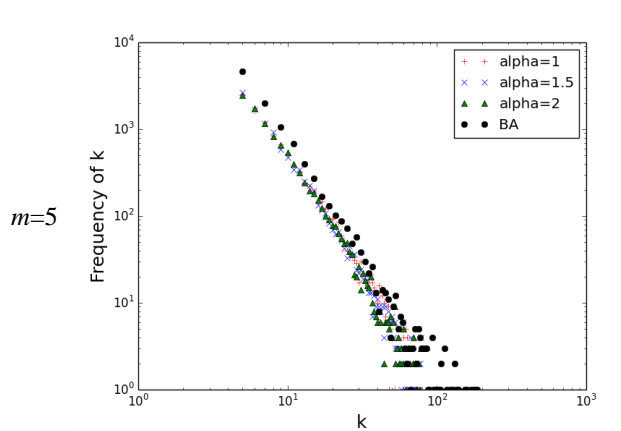
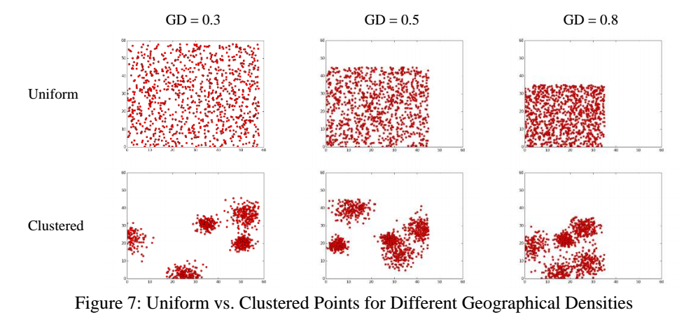
“In this paper, we propose a class of models for generating spatial versions of three classic networks: Erdös-Rényi (ER), Watts-Strogatz (WS), and Barabási-Albert (BA). We assume that nodes have geographical coordinates, are uniformly distributed over an m × m Cartesian space, and long-distance connections are penalized. Our computational results show higher clustering coefficient, assortativity, and transitivity in all three spatial networks, and imperfect power law degree distribution in the BA network. Furthermore, we analyze a special case with geographically clustered coordinates, resembling real human communities, in which points are clustered over k centers. Comparison between the uniformly and geographically clustered versions of the proposed spatial networks show an increase in values of the clustering coefficient, assortativity, and transitivity, and a lognormal degree distribution for spatially clustered ER, taller degree distribution and higher average path length for spatially clustered WS, and higher clustering coefficient and transitivity for the spatially clustered BA networks.”
Keywords: Spatial social networks, Network properties, Random network, Small-world network, Scale-free network.
The Python code for the models can be found here.
Full Reference:
Alizadeh, M., Cioffi-Revilla, C. and Crooks, A. (2016), Generating and Analyzing Spatial Social Networks. Computational and Mathematical Organization Theory, DOI: 10.1007/s10588-016-9232-2 (pdf)
The RGS-IBG annual conference has been on this week, and I presented as part of a series of geocomputation sessions arranged in advance of the 21st anniversary Geocomputation conference in Leeds next year. The topic was current CASA research from the RESOLUTION project, looking at developing fast and consistent methods of measuring public transport accessibility between different … Continue reading Open Source Public Transport Accessibility Modelling →![]()