Book review: A Framework for Geodesign:
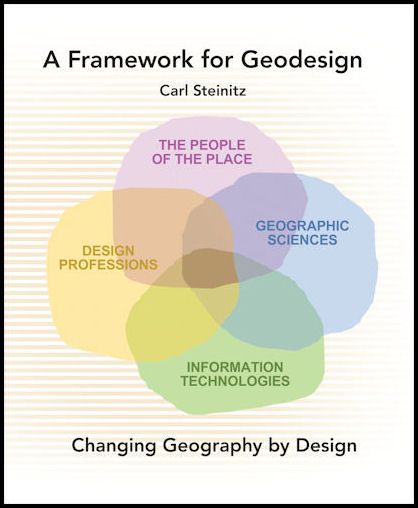
In his book “A Framework for Geodesign: Changing Geography by Design” Karl Steinitz brings his vast experience as a landscape architect and planner to such an issue. For those not familiar to the term geodesign, Steinitz (2012) writes in his preference to the book that it “is an invented word, and a very useful term to describe an activity that is not the territory of any single design profession, geographic science or information technology” (p ix). More generally Steinitz (2012) frames geodesign as “the development and application of design-related processes intended to change the geographical study areas in which they are applied and realised” (p1). Or another way of putting it, the merging of geography and design through computers. This is reiterated later on by a quote from Michael Flaxman were he states “Geodesign is a design and planning method which tightly couples the creation of design proposals with impact simulations informed by geographic contexts, systems thinking, and digital technology” (Flaxman quoted in Steinitz, 2012 p 12).
Moreover, geodesign can be considered both as a verb and as a noun which Steinitz relates to design more generally (see Steinitz, 1995). In the sense as a verb, geodesign is about asking questions and as a noun, geodesign is the content of the answers. In this book Steinitz not only clears up the meaning of geodesign but more importantly provides a comprehensive framework (based on his past work) for thinking about strategies of geodesign, and for organising and operationalizing these meanings.
The book is made up of twelve chapters and split into four parts. The first part is spent on framing geodesign and to set the scene for the remainder of book. For example, chapter 1 notes that for geodesign to be successful, one requires collaboration between the design professions (e.g. architects, planners, urban designers, etc.), geographical sciences (e.g. geographers, ecologists, etc), information technologies and those people living within the communities where geodesign is being applied. This is reiterated throughout the book. Chapter 1 also traces the history of geodesign, and how the advent of computer methods for the acquisition, management and display of digital data can be used to link many participants, thus making design not a solitary activity. Chapter 2 introduces the reader to the context for geodesign in the sense that 1) geography matters and that different societies think differently about their geography, 2) scale maters in the sense of what scale should a geodesign project be applied at (e.g., local, regional or global), and what are the appropriate considerations that need to incorporated at each scale, and finally 3) size matters, if the size of the geographic study area increases, there is a high risk of a harmful impact if one makes a mistake.
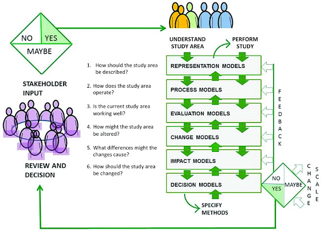
Part 2 of the book lays out a framework for geodesign. It is important to note that Steinitz does not call this a methodology for geodesign, as he argues one cannot have a singular methodology as the approaches, principles and methods are applied to projects across a range of geographies, scales and sizes. He therefore introduces a framework as a verb, specifically for asking questions, choosing among many methods and seeking possible answers. In order to develop this framework Steinitz walks the reader through six different questions and types of models common in geodesign projects.
Chapter 3 focuses on components of the framework and the questions one needs to address for a successful geodesign project. These questions broadly range from: 1) How should the study area be described? 2) How does the study area operate? 3) Is the current study area working well? 4) How might the study area be altered? 5) What differences might the changes cause?, and finally, 6) How should the study area be changed? As posed by Steinitz, these questions are not a linear progression, but have several iterative loops and feedbacks both with the geodesign team and the application stakeholders. Moreover, Steinitz argues that such questions should be asked three times during the geodesign study, the first to treat them as why questions (e.g. to understand the geographic study area and the scope of the study). Secondly, the questions are asked in reverse order to identify the how questions (e.g. to define the methods of the study, therefore geodesign becomes a decision rather than data driven process) and finally, the questions are asked in sequential order to address the what, where and when questions as the geodesign study is being implemented. Once these three iterations are complete, there can be three possible decisions, yes, no and maybe. If maybe or no, more feedback is needed between the geodesign team and the stakeholders. These iterations highlight how geodesign is an on-going process of changing geography by design.
Overall the book is extremely well written and Steinitz provides a critical and personal account of geodesign, which shows his expertise in the area from his years of teaching and carrying out geodesign work. The use of figures and real world examples really helps support the discussion. But if you are looking for a textbook for “how to” do geodesign, or a list of technologies that enable geodesign, you need to look elsewhere. This is a book the principles and practice of geodesign in a general sense, and which provides a valuable resource for those interested in this topic.”
References:
Brail, R.K. (ed.) (2008), Planning Support Systems for Cities and Regions, Lincoln Institute of Land Policy, Cambridge, MA.
Ervin, S. (2011), ‘A System for GeoDesign’, Proceedings of Digital Landscape Architecture, Anhalt University of Applied Science, Dessau, Germany, pp. 145-154.
Goodchild, M.F. (2010), ‘Towards Geodesign: Repurposing Cartography and GIS?.’ Cartographic Perspectives, 66(7-22).
Longley, P.A., Goodchild, M.F., Maguire, D.J. and Rhind, D.W. (2010), Geographical Information Systems and Science (3rd Edition), John Wiley & Sons, New York, NY.
Steinitz, C. (1995), ‘Design is a Verb; Design is a Noun’, Landscape Journal, 14(2): 188-200.
Steinitz, C. (2012), A Framework for Geodesign: Changing Geography by Design, ESRI Press, Redlands. CA.
Full reference to the book:
Review of Steinitz, C. (2012), A Framework for Geodesign: Changing Geography by Design, ESRI Press, Redlands. CA.
Full reference to the review:
Continue reading »Crooks, A.T. (2013), Crooks on Steinitz: A Framework for Geodesign: Changing Geography by Design, Environment and Planning B, 40 (6): 1122-1124.