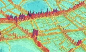
3D Map of Nitrogen Dioxide Pollution

Air pollution has long been a problem in London, and the current mayor has identified pollution as one of his major goals to highlight and tackle polluion, and improve the capital’s air quality during his time in charge. This map, of the modelled 2020 annual pollution levels of NO2, has been produced by Parallel, using […]

Continue reading »

Tranquil Pavement

Tranquil Pavement is an online map recently launched by the Tranquil City project based in London, in association with the Outlandish Cooperative and funded by Organicity. It aims to highlight tranquil places to visit, if the hustle and bustle of city life gets too much, by plotting “crowdsourced “locations – referenced in an Instagram feed […]

Continue reading »

SmellyMaps

SmellyMaps reveals the “olfactory footprint of London” – the streets which are dominated by traffic fumes, the animal smells emanating out from London Zoo, and the influence of parks and greenspaces on London’s scent experience. Streets are measured for four smell groupings – emissions (coloured red on the map), nature (green), food (blue) and animals […]

Continue reading »

New Citizen Science for air quality campaign

Mapping for Change, the social enterprise that I co-founded, has been assisting community groups to run air quality studies for the past 5 years. During this period we have worked in 30 communities across London, carrying out studies with different tools – from collecting leaves, to examining lichens, to using diffusion tubes. We have also followed … Continue reading New Citizen Science for air quality campaign

Continue reading »

London Cycle Hire and Pollution

As a cyclist in London you can do your best to avoid left turning buses and dozy pedestrians. One thing you can’t really avoid though is pollution (although I accept cyclists probably aren’t much worse off than pedestrians and drivers in this respect). To illustrate this I have taken data for 3.2 million journeys from …

Continue reading »