King’s Cross’ Monster Trail
King’s Cross Central, the area behind King’s Cross and St Pancras stations, has launched a monster trail, which is running up to and including Hallowe’en
Continue reading »The latest outputs from researchers, alumni and friends at the UCL Centre for Advanced Spatial Analysis (CASA).

King’s Cross Central, the area behind King’s Cross and St Pancras stations, has launched a monster trail, which is running up to and including Hallowe’en
Continue reading »The new map is the latest in a long line in attractively packaged, specialist maps from Blue Crow Media which highlight the locations of a single feature of London on a bepoke basemap and guide – be it notable trees, Brutalist buildings or in thi…
Continue reading »Central London has long been a spatial challenge for tourists and others unfamiliar with it. It’s very big, and most of it isn’t built on an easily understandable grid pattern. Quirks and kinks in streets built back in Roman times, persist …
Continue reading »Various central London locations are this week, as part of London Car Free Day (which is today!), stocking free copies of a paper map (you can also order a copy online) for walking routes in central London – it’s called Footways, and was fi…
Continue reading »The London Greenground Map, by designer Helen Ilus (Hi Design), takes its inspiration from the famous tube map to create a network of walking routes, with parks as “stations” in and around the capital. The map was first created a couple of …
Continue reading »We’ve all had plenty of to explore our local areas, over the last year, with several lockdowns and other movement restrictions meaning that our local village, town or part of London is our exercise arena. With this in mind it’s always nice …
Continue reading »“Bloody London” is a new book by author, illustrator cartographer David Fathers. Previously writing about the Thames Path in London, the Regents’ Canal and London’s “lost rivers“, David has for this book focused on a…
Continue reading »This artistic map of a green walking route in central London was drawn by graphic designer Helen Ilus. By showing just the parks that are the focus of the walk, and not the rest of London’s hustle and bustle, it is an effective and attractive way…
Continue reading »
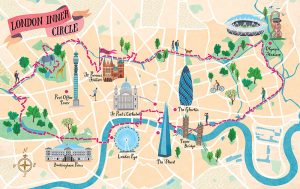
Urban Rambles is a new book by Nicholas Rudd-Jones, featuring walks through many of England’s cities. The book comes with a 22 route maps, drawn by illustrator Sara Mulvanny (see her portfolio page for the book), including a couple in London, which we feature here. Above is the “London Inner Circle” which stretches from Hyde […]
Continue reading »

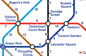
There’s a tube strike on today, with many tube stations expected to be closed. The inner city and central London are likely to be hardest hit, with stations closed in most in Zone 1 and all inside the Circle Line’s loop. Usefully, TfL recently published this map, which shows the central part of the Tube […]
Continue reading »Here is an extract of a map I co-created with Ollie O […]
Continue reading »
After reviewing many fine maps produced by others, it […]
Continue reading »
Strava, one of a number of services that walkers, runne […]
Continue reading »