Simplifying London’s Network – “Mappi Lundi”, A Hand Drawn Map
Mappa Lundi is a hand-drawn map of central London which […]
Continue reading »The latest outputs from researchers, alumni and friends at the UCL Centre for Advanced Spatial Analysis (CASA).

Mappa Lundi is a hand-drawn map of central London which […]
Continue reading »
This is an extract of a map, by Matt Ashby of the UCL S […]
Continue reading »
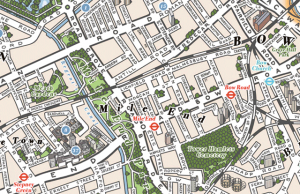
The above map is an extract from a reproduction of the […]
Continue reading »
Stephen Walter, most famous for his “Hub” m […]
Continue reading »
UbiSoft have created this compelling live map of London […]
Continue reading »
A map full of striking patterns, from Savills’ an […]
Continue reading »
This is a screenshot of a heatmap of runs carried out i […]
Continue reading »
The above is just a small extract from Stephen Walter […]
Continue reading »
As a followup to last week’s post about universit […]
Continue reading »
[Update – additional article on Middlesex University] I […]
Continue reading »
These two artwork maps (East London above, and South-Ea […]
Continue reading »
Here’s a map of Zone 1 London (concentrating on t […]
Continue reading »
Here is part of a map, The Map of Roman Britain, Second […]
Continue reading »
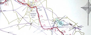
I somehow missed, until now, this set of oblique-projec […]
Continue reading »
This is a view from the LondonTown Christmas Map. While […]
Continue reading »
The London Blitz, from 1940-1941, was a traumatic event […]
Continue reading »
Ever thought the ribbon of the River Thames, weaving it […]
Continue reading »
We’ve featured at least three maps since the last […]
Continue reading »
Rentonomy, who describe themselves as, for now, “ […]
Continue reading »A book, by author and illustrator David Fathers, has re […]
Continue reading »
Silky Map is a bespoke map of central London, printed o […]
Continue reading »
Crossrail are currently building a new deep-level railw […]
Continue reading »
This map is produced by The Green Traveller in collabor […]
Continue reading »
[Updated] This map of London districts, was intended to […]
Continue reading »
Above is an extract from a map of the London Undergroun […]
Continue reading »
The A-Z is probably the most famous London Atlas – […]
Continue reading »
Thanks to the Chairman of CASA, Prof Michael Batty, for […]
Continue reading »This is an extract of a map produced in 1928 for London […]
Continue reading »This wonderful map (above is just an extract) has been […]
Continue reading »The Mind the Map exhibition, at the London Transport Mu […]
Continue reading »A major new exhibition on mapping the London Undergroun […]
Continue reading »Now this is just excellent – it’s a roll of […]
Continue reading »We featured the first official Olympic Park map at the […]
Continue reading »Stamen Design are a bespoke design and technology compa […]
Continue reading »The image above is a photo of part of a large map of Lo […]
Continue reading »This post was going to appear on Friday but I’ve […]
Continue reading »