New Paper: A Thematic Similarity Network Approach for Analysis of Places Using VGI

Building upon our work on volunteered geographical information (VGI) and ambient geographic information (AGI) and how such data (e.g. social media) can be used to understand place, Xiaoyi Yuan, Andreas Züfle and myself have a new paper entitled: “A Th…

Continue reading »

New Paper: Cancer and Social Media

Continuing our work on geosocial analysis we recently had a paper entitled “Cancer and Social Media: A Comparison of Traffic about Breast Cancer, Prostate Cancer, and Other Reproductive Cancers on Twitter and Instagram” published in the Journal of Health Communication. In the paper we  present a comparative study of differences in messaging for women’s and men’s cancer campaigns on social media through three discrete approaches. 
  1. we directly compare the incident rates of women’s and men’s cancers in the United States to the corresponding levels of traffic that these cancers elicited during World Cancer Day across two social media platforms, Twitter and Instagram. 
  2. we examine social media activity for breast cancer versus prostate cancer on both Twitter and Instagram during the dedicated month-long campaigns (October and November, respectively). 
  3. we compare the top terms associated with each campaign on these two social media platforms to discover whether there are differences in the terms associated with these online discussions.
Below you can read the abstract to our paper, see some of our results and at the bottom of the post have the full citation and link to the paper.

Abstract: 

Social media are often heralded as offering cancer campaigns new opportunities to reach the public. However, these campaigns may not be equally successful, depending on the nature of the campaign itself, the type of cancer being addressed, and the social media platform being examined. This study is the first to compare social media activity on Twitter and Instagram across three time periods: #WorldCancerDay in February, the annual month-long campaigns of National Breast Cancer Awareness Month (NBCAM) in October and Movember in November, and during the full year outside of these campaigns. Our results suggest that women’s reproductive cancers – especially breast cancer – tend to outperform men’s reproductive cancer – especially prostate cancer – across campaigns and social media platforms. Twitter overall generates substantially more activity than Instagram for both cancer campaigns, suggesting Instagram may be an untapped resource. However, the messaging for both campaigns tends to focus on awareness and support rather than on concrete actions and behaviors. We suggest health communication efforts need to focus on effective messaging and building engaged communities for cancer communication across social media platforms.

A comparison of percentages of cancer cases (green bars) and references to corresponding cancers in Twitter (blue bar) and Instagram (orange bar) during World Cancer Day 2016.

 References to breast cancer (green line), prostate cancer (orange line), and Movember (blue line) over the full year 2015 in Instagram.

Full Reference: 

Vraga, E., Stefanidis, A., Lamprianidis, G., Croitoru, A., Crooks, A.T. Delamater, P.L., Pfoser, D., Radzikowski, J. and Jacobsen, K.H. (2018), Cancer and Social Media: A Comparison of Traffic about Breast Cancer, Prostate Cancer, and Other Reproductive Cancers on Twitter and Instagram, Journal of Health Communication. 3(2), 181-189. (pdf)

Continue reading »

Zika in Twitter: Health Narratives

In the paper we explored how health narratives and event storylines pertaining to the recent Zika outbreak emerged in social media and how it related to news stories and actual events.

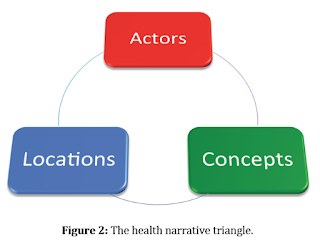
Specifically we combined actors (e.g. twitter uses), locations (e.g. where the tweets originated) and concepts (e.g. emerging narratives such as pregnancy) to gain insights on the mechanisms that drive participation, contributions, and interactions on social media  during a disease outbreak. Below you can read a summary of our paper along with some of the figures which highlight our methodology and findings.  
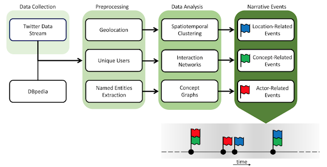
An overview of the Twitter narrative analysis approach, starting with data collection, and proceeding with preprocessing and data analysis to identify narrative events, which can be used to build an event storyline.

Abstract:
 

Background: The recent Zika outbreak witnessed the disease evolving from a regional health concern to a global epidemic. During this process, different communities across the globe became involved in Twitter, discussing the disease and key issues associated with it. This paper presents a study of this discussion in Twitter, at the nexus of location, actors, and concepts.

Objective: Our objective in this study was to demonstrate the significance of 3 types of events: location related, actor related, and concept- related for understanding how a public health emergency of international concern plays out in social media, and Twitter in particular. Accordingly, the study contributes to research efforts toward gaining insights on the mechanisms that drive participation, contributions, and interaction in this social media platform during a disease outbreak. 

Methods: We collected 6,249,626 tweets referring to the Zika outbreak over a period of 12 weeks early in the outbreak (December 2015 through March 2016). We analyzed this data corpus in terms of its geographical footprint, the actors participating in the discourse, and emerging concepts associated with the issue. Data were visualized and evaluated with spatiotemporal and network analysis tools to capture the evolution of interest on the topic and to reveal connections between locations, actors, and concepts in the form of interaction networks. 

Results: The spatiotemporal analysis of Twitter contributions reflects the spread of interest in Zika from its original hotspot in South America to North America and then across the globe. The Centers for Disease Control and World Health Organization had a prominent presence in social media discussions. Tweets about pregnancy and abortion increased as more information about this emerging infectious disease was presented to the public and public figures became involved in this. 

Conclusions: The results of this study show the utility of analyzing temporal variations in the analytic triad of locations, actors, and concepts. This contributes to advancing our understanding of social media discourse during a public health emergency of international concern.

Keywords: Zika Virus; Social Media; Twitter Messaging; Geographic Information Systems.
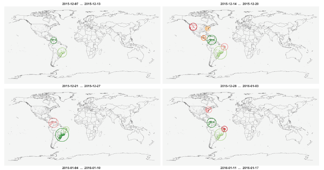
Spatiotemporal participation patterns and identifiable clusters over 4 of our twelve week study. The top left panel shows the data during the first week, and time progresses from left to right and from top to bottom towards .

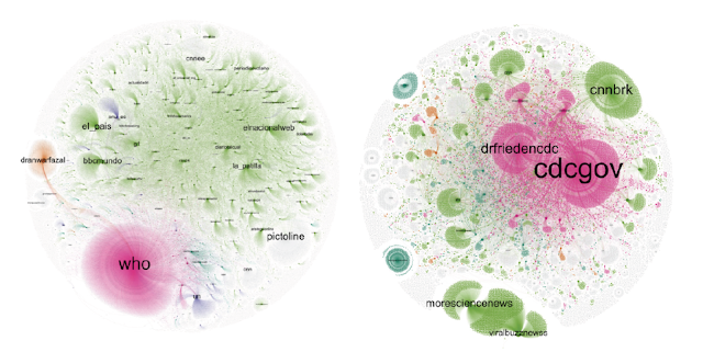
Subsets of the full retweet network pertaining to the WHO (left) and CDC (right), and clusters identified within them. Magenta clusters are centered upon health entities, green upon news organizations, orange upon political entities.

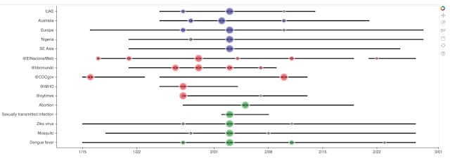
Visualizing a narrative storyline across locations (blue), actors (red), and concepts (green).

Full Reference:

Stefanidis, A., Vraga, E., Lamprianidis, G., Radzikowski, J., Delamater, P.L., Jacobsen, K.H., Pfoser, D., Croitoru, A. and Crooks, A.T. (2017). “Zika in Twitter: Temporal Variations of Locations, Actors, and Concepts”, JMIR Public Health and Surveillance, 3 (2): e22. (pdf)

As normal, any feedback or comments are most welcome. 

Continue reading »

Zika in Twitter: Health Narratives

In the paper we explored how health narratives and event storylines pertaining to the recent Zika outbreak emerged in social media and how it related to news stories and actual events.

Specifically we combined actors (e.g. twitter uses), locations (e.g. where the tweets originated) and concepts (e.g. emerging narratives such as pregnancy) to gain insights on the mechanisms that drive participation, contributions, and interactions on social media  during a disease outbreak. Below you can read a summary of our paper along with some of the figures which highlight our methodology and findings.  

An overview of the Twitter narrative analysis approach, starting with data collection, and proceeding with preprocessing and data analysis to identify narrative events, which can be used to build an event storyline.

Abstract:
 

Background: The recent Zika outbreak witnessed the disease evolving from a regional health concern to a global epidemic. During this process, different communities across the globe became involved in Twitter, discussing the disease and key issues associated with it. This paper presents a study of this discussion in Twitter, at the nexus of location, actors, and concepts.

Objective: Our objective in this study was to demonstrate the significance of 3 types of events: location related, actor related, and concept- related for understanding how a public health emergency of international concern plays out in social media, and Twitter in particular. Accordingly, the study contributes to research efforts toward gaining insights on the mechanisms that drive participation, contributions, and interaction in this social media platform during a disease outbreak. 

Methods: We collected 6,249,626 tweets referring to the Zika outbreak over a period of 12 weeks early in the outbreak (December 2015 through March 2016). We analyzed this data corpus in terms of its geographical footprint, the actors participating in the discourse, and emerging concepts associated with the issue. Data were visualized and evaluated with spatiotemporal and network analysis tools to capture the evolution of interest on the topic and to reveal connections between locations, actors, and concepts in the form of interaction networks. 

Results: The spatiotemporal analysis of Twitter contributions reflects the spread of interest in Zika from its original hotspot in South America to North America and then across the globe. The Centers for Disease Control and World Health Organization had a prominent presence in social media discussions. Tweets about pregnancy and abortion increased as more information about this emerging infectious disease was presented to the public and public figures became involved in this. 

Conclusions: The results of this study show the utility of analyzing temporal variations in the analytic triad of locations, actors, and concepts. This contributes to advancing our understanding of social media discourse during a public health emergency of international concern.

Keywords: Zika Virus; Social Media; Twitter Messaging; Geographic Information Systems.

Spatiotemporal participation patterns and identifiable clusters over 4 of our twelve week study. The top left panel shows the data during the first week, and time progresses from left to right and from top to bottom towards .

Subsets of the full retweet network pertaining to the WHO (left) and CDC (right), and clusters identified within them. Magenta clusters are centered upon health entities, green upon news organizations, orange upon political entities.

Visualizing a narrative storyline across locations (blue), actors (red), and concepts (green).

Full Reference:

Stefanidis, A., Vraga, E., Lamprianidis, G., Radzikowski, J., Delamater, P.L., Jacobsen, K.H., Pfoser, D., Croitoru, A. and Crooks, A.T. (2017). “Zika in Twitter: Temporal Variations of Locations, Actors, and Concepts”, JMIR Public Health and Surveillance, 3 (2): e22. (pdf)

As normal, any feedback or comments are most welcome. 

Continue reading »

Measles Vaccination Narrative in Twitter

A summary of our approach
Continuing our work with respects to GeoSocial analysis we have recently published a paper in JMIR Public Health and Surveillance entitled “The Measles Vaccination Narrative in Twitter: A Quantitative Analysis“. In this paper we explore how social media can be quantitatively studied to explore the narrative behind measles vaccinations. Below you can read the abstract to the paper which includes the background to why we chose to study this topic, the study objective, our methodology, a summary of our results and conclusions. 

Background: The emergence of social media is providing an alternative avenue for information exchange and opinion formation on health-related issues. Collective discourse in such media leads to the formation of a complex narrative, conveying public views and perceptions.

Objective: This paper presents a study of Twitter narrative regarding vaccination in the aftermath of the 2015 measles outbreak, both in terms of its cyber and physical characteristics. The contributions of this work are the analysis of the data for this particular study, as well as presenting a quantitative interdisciplinary approach to analyze such open-source data in the context of health narratives.

Methods: 669,136 tweets were collected in the period February 1 through March 9, 2015 referring to vaccination. These tweets were analyzed to identify key terms, connections among such terms, retweet patterns, the structure of the narrative, and connections to the geographical space.

Results: The data analysis captures the anatomy of the themes and relations that make up the discussion about vaccination in Twitter. The results highlight the higher impact of stories contributed by news organizations compared to direct tweets by health organizations in communicating health-related information. They also capture the structure of the anti-vaccination narrative and its terms of reference. Analysis also revealed the relationship between community engagement in Twitter and state policies regarding child vaccination. Residents of Vermont and Oregon, the two states with the highest rates of non-medical exemption from school-entry vaccines nationwide, are leading the social media discussion in terms of participation.

Conclusions: The interdisciplinary study of health-related debates in social media across the cyber-physical debate nexus leads to a greater understanding of public concerns, views, and responses to health-related issues. Further coalescing such capabilities shows promise towards advancing health communication, supporting the design of more effective strategies that take into account the complex and evolving public views of health issues.

Global distribution of tweets in our data corpus
The paper is open access and can be viewed and downloaded from here.
Full reference:

Radzikowski, J., Stefanidis, A., Jacobsen K.H., Croitoru, A., Crooks, A.T. and Delamater, P.L. (2016). “The Measles Vaccination Narrative in Twitter: A Quantitative Analysis”, JMIR Public Health and Surveillance, 2(1):e1. 

Hashtag associations: clustering based on co-occurrences of hashtags in individual tweets
Continue reading »

Mapping Protest in 3D with Twitter Data


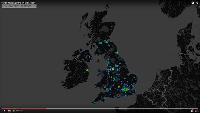
As one part of my docotoral thesis, I have made the video that shows the relationship between ‘London End Austerity Now’ Protest on 20thJune 2015 and the Twitter acitivity on that day.

The video gives you some details about the protest, the data and 3D visualisation.
If the following YouTube video is not displayed on your device, please use this link. 


Continue reading »

Mapping Protest in 3D with Twitter Data


As one part of my docotoral thesis, I have made the video that shows the relationship between ‘London End Austerity Now’ Protest on 20thJune 2015 and the Twitter acitivity on that day.

The video gives you some details about the protest, the data and 3D visualisation.
If the following YouTube video is not displayed on your device, please use this link. 


Continue reading »

Mapping Protest in 3D with Twitter Data

As one part of my docotoral thesis, I have made the video that shows the relationship between ‘London End Austerity Now’ Protest on 20thJune 2015 and the Twitter acitivity on that day.The video gives you some details about the protest, the data and 3D …

Continue reading »
Mapping London’s Twitter Activity in 3d

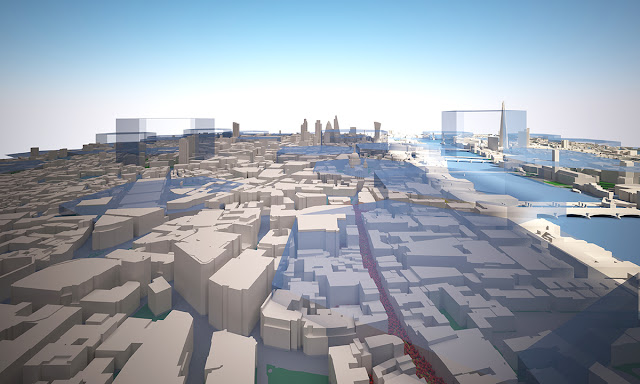
Image 1. The tweet density from 8am to 4pm on 20th June 2015, Central London


Twitter Mapping is increasingly useful method to link virtual activities and geographical space. Geo-tagged data attached to tweets containing the users’ location where they tweeted and it can visualise the locations of users on the map. Although the number of the geo-taggedtweets is a relatively small portion of all tweets, we can figure out the density, spatial patterns and other invisible relationships between online and offline.


Recently, studies with geo-tagged tweets have been developed to analyse the public response tospecific urban events, natural disasters and regional characteristics (Li et al., 2013) [1].  Furthermore, it is extending to traditional urban research topics, for example, revealing spatial segregation and inequality in cities (Shelton et al., 2015) [2].


Twitter mapping in 3D can augment 2d visualisation by providing built environment contexts and improved information. There are many examples of Twitter mapping in 3d such as A) #interactive/Andes [3] , B) London’s Twitter Island [4], C) Mapping London in real time, using Tweets [5]. A) and B) build up 3d mountains of the geo-tagged tweet on the map.  In the case of C), when the geo-tagged tweets are sent in the city, the heights of nearest buildings increase in the 3d model. These examples are creative and show different ways to view the integrated environments.

From a Networking City’s view, if we make a Twitter visualisation more tangible in a 3d urban model, it would help us to have a better understanding how urban environments are interconnected with the invisible media flow.


To make the visualisation, the Twitter data has been collected by using Big Data Toolkit developed by Steven Gray at CASA, UCL. All 53,750 geo-tagged tweets are collected on 20thJune, 2015 across the UK. As we can see from Table 1, the number of tweets was at the lowest point at 5am and reached to the highest point at 10pm with 3495 tweets. Moreover, Video 1 shows the location of the data in the UK and London on that day in real time.


Table 1. The Number of Geo-Coded Tweets in the UK on 20th June, 2015


https://www.youtube.com/watch?v=dg-2VlVfFaM


Video 1. The location of Geo-Coded Tweets in the UK on 20th June, 2015


When we calculate the density of the data, London, particularly Central London, contains the largest number of the tweets. (Image 2)


Image 2. The density of Geo-Coded Tweets in the UK on 20th June, 2015

In order to focus on the high density data, 6 km x 3.5 km area of Central London is chosen for the 3d model. Buildings, bridges, roads and other natural environments of the part of London have been set in the model based on OS Building Heights data[6]. Some Google 3d warehouse buildings are added to represent important landmark buildings like St.Pauls, London Eye and Tower Bridge as you can see from Image 3, Image 4 and Image 5.


Image 3. The plan view of Central London model

Image 4. The perspective view of Central London model

Image 5. The perspective view of Central London model (view from BT Tower)

The geo-tagged data set is divided into one hour periodsand distributed on the map to identify the tweet density in the area. Through this process, we can see how the density is changing depending on the time period. For example, the tweets are mainly concentrated around Piccadilly Circus and Trafalgar Square between 10am and 11am, but  there are two high-density areas between 12pm and 1pm (See Image 6, Image 7, Image 8 and Image 9)

Image 6. The tweet density between 10am and 11am on 20th June 2015

Image 7. The tweet density between 12pm and 1pm on 20th June 2015

Image 8. The tweet density from 12am to 12pm

Image 9. The tweet density from 12pm to Midnight


As we’ve seen above, the 2d mapping is useful to understand the relative density in one period such as which area is high and which area is low between 12pm and 1pm. However, we cannot understand the degree of intensity in the highest peak areas. It is believed that 3d mapping is needed at this stage. We can clearly see the density of the tweet data in each periodand the intensity of the tweet density across the time periods from Image 10 to Image 14.

West End area shows high density throughout the whole day but City area shows the peak only during lunch time. This pattern likely relates to the activities of office workers in City and leisure/tourist in West End.

Image 10. The tweet density in 3d between 10am and 11am on 20th June 2015

Image 11. The tweet density in 3d between 12pm and 1pm on 20th June 2015


Image 12. The tweet density in 3d from 12am to 8pm

Image 13. The tweet density in 3d from 8am to 4pm

Image 14. The tweet density from 4pm to Midnight


 ________________________________________

[1] Linna Li , Michael F. Goodchild & Bo Xu (2013) Spatial, temporal, and socioeconomic patterns in the use of Twitter and Flickr, Cartography and Geographic Information Science, 40:2, 61-77


[2] Taylor Shelton, Ate Poorthuis & Matthew Zook (2015) Social Media and the City: Rethinking Urban Socio-Spatial Inequality Using User-Generated Geographic Information, Landscape and Urban Planning (Forthcoming), http://papers.ssrn.com/abstract=2571757


[3] Nicolas Belmonte, #interactive/Andes,   http://twitter.github.io/interactive/andes/  (Strived on 15th August 2015)


[4] Andy Hudson-Smith, London’s Twitter Island – From ArcGIS to Max to Lumion, http://www.digitalurban.org/2012/01/londons-twitter-island-from-arcgis-to.html#comment-7314


(Strived on 15thAugust 2015)

 
[5] Stephan Hugel and Flora Roumpani, Mapping London in real time, using Tweets, https://www.youtube.com/watch?feature=player_embedded&v=3fk_qxGZWFQ (Strived on 15th August 2015)

[6] OS Building Heights-Digimap Home Page  http://digimap.edina.ac.uk/webhelp/os/data_information/os_products/os_building_heights.htm  (Strived on 15th August 2015)


Continue reading »

Mapping London’s Twitter Activity in 3d

Image 1. The tweet density from 8am to 4pm on 20th June 2015, Central London


Twitter Mapping is increasingly useful method to link virtual activities and geographical space. Geo-tagged data attached to tweets containing the users’ location where they tweeted and it can visualise the locations of users on the map. Although the number of the geo-taggedtweets is a relatively small portion of all tweets, we can figure out the density, spatial patterns and other invisible relationships between online and offline.


Recently, studies with geo-tagged tweets have been developed to analyse the public response tospecific urban events, natural disasters and regional characteristics (Li et al., 2013) [1].  Furthermore, it is extending to traditional urban research topics, for example, revealing spatial segregation and inequality in cities (Shelton et al., 2015) [2].


Twitter mapping in 3D can augment 2d visualisation by providing built environment contexts and improved information. There are many examples of Twitter mapping in 3d such as A) #interactive/Andes [3] , B) London’s Twitter Island [4], C) Mapping London in real time, using Tweets [5]. A) and B) build up 3d mountains of the geo-tagged tweet on the map.  In the case of C), when the geo-tagged tweets are sent in the city, the heights of nearest buildings increase in the 3d model. These examples are creative and show different ways to view the integrated environments.

From a Networking City’s view, if we make a Twitter visualisation more tangible in a 3d urban model, it would help us to have a better understanding how urban environments are interconnected with the invisible media flow.


To make the visualisation, the Twitter data has been collected by using Big Data Toolkit developed by Steven Gray at CASA, UCL. All 53,750 geo-tagged tweets are collected on 20thJune, 2015 across the UK. As we can see from Table 1, the number of tweets was at the lowest point at 5am and reached to the highest point at 10pm with 3495 tweets. Moreover, Video 1 shows the location of the data in the UK and London on that day in real time.


Table 1. The Number of Geo-Coded Tweets in the UK on 20th June, 2015


https://www.youtube.com/watch?v=dg-2VlVfFaM


Video 1. The location of Geo-Coded Tweets in the UK on 20th June, 2015


When we calculate the density of the data, London, particularly Central London, contains the largest number of the tweets. (Image 2)


Image 2. The density of Geo-Coded Tweets in the UK on 20th June, 2015

In order to focus on the high density data, 6 km x 3.5 km area of Central London is chosen for the 3d model. Buildings, bridges, roads and other natural environments of the part of London have been set in the model based on OS Building Heights data[6]. Some Google 3d warehouse buildings are added to represent important landmark buildings like St.Pauls, London Eye and Tower Bridge as you can see from Image 3, Image 4 and Image 5.


Image 3. The plan view of Central London model

Image 4. The perspective view of Central London model

Image 5. The perspective view of Central London model (view from BT Tower)

The geo-tagged data set is divided into one hour periodsand distributed on the map to identify the tweet density in the area. Through this process, we can see how the density is changing depending on the time period. For example, the tweets are mainly concentrated around Piccadilly Circus and Trafalgar Square between 10am and 11am, but  there are two high-density areas between 12pm and 1pm (See Image 6, Image 7, Image 8 and Image 9)

Image 6. The tweet density between 10am and 11am on 20th June 2015

Image 7. The tweet density between 12pm and 1pm on 20th June 2015

Image 8. The tweet density from 12am to 12pm

Image 9. The tweet density from 12pm to Midnight


As we’ve seen above, the 2d mapping is useful to understand the relative density in one period such as which area is high and which area is low between 12pm and 1pm. However, we cannot understand the degree of intensity in the highest peak areas. It is believed that 3d mapping is needed at this stage. We can clearly see the density of the tweet data in each periodand the intensity of the tweet density across the time periods from Image 10 to Image 14.

West End area shows high density throughout the whole day but City area shows the peak only during lunch time. This pattern likely relates to the activities of office workers in City and leisure/tourist in West End.

Image 10. The tweet density in 3d between 10am and 11am on 20th June 2015

Image 11. The tweet density in 3d between 12pm and 1pm on 20th June 2015


Image 12. The tweet density in 3d from 12am to 8pm

Image 13. The tweet density in 3d from 8am to 4pm

Image 14. The tweet density from 4pm to Midnight


 ________________________________________

[1] Linna Li , Michael F. Goodchild & Bo Xu (2013) Spatial, temporal, and socioeconomic patterns in the use of Twitter and Flickr, Cartography and Geographic Information Science, 40:2, 61-77


[2] Taylor Shelton, Ate Poorthuis & Matthew Zook (2015) Social Media and the City: Rethinking Urban Socio-Spatial Inequality Using User-Generated Geographic Information, Landscape and Urban Planning (Forthcoming), http://papers.ssrn.com/abstract=2571757


[3] Nicolas Belmonte, #interactive/Andes,   http://twitter.github.io/interactive/andes/  (Strived on 15th August 2015)


[4] Andy Hudson-Smith, London’s Twitter Island – From ArcGIS to Max to Lumion, http://www.digitalurban.org/2012/01/londons-twitter-island-from-arcgis-to.html#comment-7314


(Strived on 15thAugust 2015)

 
[5] Stephan Hugel and Flora Roumpani, Mapping London in real time, using Tweets, https://www.youtube.com/watch?feature=player_embedded&v=3fk_qxGZWFQ (Strived on 15th August 2015)

[6] OS Building Heights-Digimap Home Page  http://digimap.edina.ac.uk/webhelp/os/data_information/os_products/os_building_heights.htm  (Strived on 15th August 2015)


Continue reading »

Mapping London’s Twitter Activity in 3d

Image 1. The tweet density from 8am to 4pm on 20th June 2015, Central London Twitter Mapping is increasingly useful method to link virtual activities and geographical space. Geo-tagged data attached to tweets containing the users’ location where the…

Continue reading »
1 2 3