Advances in Geographic Data Science – Open Data and Systems
Talk given at the EEO-AGI seminar series at the University of Edinburgh 31/1/14.
Continue reading »The latest outputs from researchers, alumni and friends at the UCL Centre for Advanced Spatial Analysis (CASA).

Talk given at the EEO-AGI seminar series at the University of Edinburgh 31/1/14.
Continue reading »Talk given at the EEO-AGI seminar series at the University of Edinburgh 31/1/14.
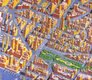
Continue reading »Once upon a time, Streetmap.co.uk was one of the most popular Web Mapping sites in the UK, competing successfully with the biggest rival at the time, Multimap. Moreover, it was ranked second in The Daily Telegraph list of leading mapping sites in October 2000 and described at ‘Must be one of the most useful services on […]![]()

Diamond Geezer escaped from London by plotting the shortest distance (as the crow flies) from his home to the London boundary, and then taking the shortest walking route that gets to that same point on the boundary. He identified a pub in Woodford Green as the closest point on the boundary from a nominal start […]
Continue reading »Image 1. The book cover of ‘Designing Cities: Basics, Principles, Projects’ What is the basic knowledge for urban design? Which techniques are necessary for designing decent urban spaces? ‘Designing Cities: Basics, Principles, Projects’, wr…
Continue reading »
 |
| Image 1. The book cover of ‘Designing Cities: Basics, Principles, Projects’ |
The book is structured along three parts,
1) General principles of urban design
2) Practical techniques for designing cities with relative examples
 |
| Image 2. The sample page of Chpter 2. Page 18 and 19 |
 |
| Image 3. The sample page of Chpter 2. Page 20 and 21 |
 |
| Image 4. Good project images are helpful to understand the intention of the author. Page 40 and 41 |
 |
| Image 5. Sample pages. Page 74 and 75 |
 |
| Image 6. Sample pages. Page 110 and 111 |
 |
| Image 7. Sample pages. Page 276 and 277 |
 |
| Image 8. Sample pages. Page 280 and 281 |
Designing Cities: Basics, Principles, ProjectsHardcover: 356 pages
Publisher: Birkhauser Verlag AG (25 July 2013)
Language: English
ISBN-10: 3034613253
ISBN-13: 978-3034613255
Product Dimensions: 24.4 x 17.5 x 3 cm
Amazon UK http://bit.ly/KRenmV
Continue reading »
|
| Image 1. The book cover of ‘Designing Cities: Basics, Principles, Projects’ |
The book is structured along three parts,
1) General principles of urban design
2) Practical techniques for designing cities with relative examples
|
| Image 2. The sample page of Chpter 2. Page 18 and 19 |
|
| Image 3. The sample page of Chpter 2. Page 20 and 21 |
|
| Image 4. Good project images are helpful to understand the intention of the author. Page 40 and 41 |
|
| Image 5. Sample pages. Page 74 and 75 |
|
| Image 6. Sample pages. Page 110 and 111 |
|
| Image 7. Sample pages. Page 276 and 277 |
|
| Image 8. Sample pages. Page 280 and 281 |
Designing Cities: Basics, Principles, ProjectsHardcover: 356 pages
Publisher: Birkhauser Verlag AG (25 July 2013)
Language: English
ISBN-10: 3034613253
ISBN-13: 978-3034613255
Product Dimensions: 24.4 x 17.5 x 3 cm
Amazon UK http://bit.ly/KRenmV
Continue reading »

|
| Image 1. The book cover of ‘Designing Cities: Basics, Principles, Projects’ |
The book is structured along three parts,
1) General principles of urban design
2) Practical techniques for designing cities with relative examples
|
| Image 2. The sample page of Chpter 2. Page 18 and 19 |
|
| Image 3. The sample page of Chpter 2. Page 20 and 21 |
|
| Image 4. Good project images are helpful to understand the intention of the author. Page 40 and 41 |
|
| Image 5. Sample pages. Page 74 and 75 |
|
| Image 6. Sample pages. Page 110 and 111 |
|
| Image 7. Sample pages. Page 276 and 277 |
|
| Image 8. Sample pages. Page 280 and 281 |
Designing Cities: Basics, Principles, ProjectsHardcover: 356 pages
Publisher: Birkhauser Verlag AG (25 July 2013)
Language: English
ISBN-10: 3034613253
ISBN-13: 978-3034613255
Product Dimensions: 24.4 x 17.5 x 3 cm
Amazon UK http://bit.ly/KRenmV
Continue reading »
When members of staff within your department retire, there are usually office clearouts, resulting in piles of interesting old books being given away.
A recent addition to my collection is a cartographic gem from 1995 titled “Statlas UK: A Statistic…
Continue reading »UCL has many famous sons. Brian Berry graduated here in 1955 before he went Stateside and Roger Tomlinson, the ‘father of GIS’ who coined the very term in the early 1960s, did his PhD here. Carl Steinitz who is a … Continue reading →
Continue reading »Tweet CALL FOR PAPERS Population Geographies of Childhood and Youth Fourth Biannual British-Irish Population Conference 12th-13th May 2014 Hosted by Department of Geography, Swansea University under the auspices of the Population Geography Research Group of the RGS-IBG Papers are invited for a forthcoming conference on any aspects of the Population Geographies of Childhood […]
Continue reading »
In the past I have blogged (and even written papers) about agent-based modeling toolkits / frameworks such as MASON, Repast and NetLogo for the creation of models. One issue is the deployment of models over the internet. Thanks to Richard Milton from t…
Continue reading »
In the past I have blogged (and even written papers) about agent-based modeling toolkits / frameworks such as MASON, Repast and NetLogo for the creation of models. One issue is the deployment of models over the internet. Thanks to Richard Milton from t…
Continue reading »
In the past I have blogged (and even written papers) about agent-based modeling toolkits / frameworks such as MASON, Repast and NetLogo for the creation of models. One issue is the deployment of models over the internet. Thanks to Richard Milton from t…
Continue reading »
Over the last year I have been working with Ammar Malik and Hilton Root on a small project which explores the relationship between human creativity and urban development via an agent-based model. We have recently just completed a working paper for this…
Continue reading »
Over the last year I have been working with Ammar Malik and Hilton Root on a small project which explores the relationship between human creativity and urban development via an agent-based model. We have recently just completed a working paper for this…
Continue reading »
Over the last year I have been working with Ammar Malik and Hilton Root on a small project which explores the relationship between human creativity and urban development via an agent-based model. We have recently just completed a working paper for this…
Continue reading »Following the two previous assertions, namely that: ‘you can be supported by a huge crowd for a very short time, or by few for a long time, but you can’t have a huge crowd all of the time (unless data collection is passive)’ (original post here) And ‘All information sources are heterogeneous, but some are more […]![]()

I’m now the proud owner of this lovely green glass globe paperweight – it was my prize from the web map category of the mapping competition at the FOSS4G conference last year, but it’s taken me this long to finally get my hands on it, as I was disappearing on a train before the end […]
Continue reading »About a year ago, I wrote this post which rounded up some useful books showcasing and providing techniques for datavis. I should say that I’m primarily a programmatic visualator (i.e I tend not to deal with the GUI-style visualisation platforms, … Continue reading →![]()
About a year ago, I wrote this post which rounded up some useful books showcasing and providing techniques for datavis. I should say that I’m primarily a programmatic visualator (i.e I tend not to deal with the GUI-style visualisation platforms, … Continue reading →![]()
|
10 Years of London Underground Ridership Data in One Map
The Atlantic Cities Oliver O’Brien, a researcher at the University College London’s Center for Advanced Spatial Analysis (and the developer behind an equally entrancing global bikeshare visualization), has just put all of these Tube stats online in an in-depth interactive … |

London Tube Stats maps data about how the London Underground is used – how many people use each station at various times of the day, and where they go once they are on the tube. Transport for London, the city’s public transport authority, have a huge amount of data available in their Developers’ Area website, […]
Continue reading »10 Years of London Underground Ridership Data in One Map Bloomberg
Continue reading »I am not a great fan of pie charts since they are often […]
Continue reading »
Many maps use overlays to display different types of features on the map. Many examples show old hand drawn maps that have been re-projected to fit on our modern day, online ‘slippy’ map but
very few show these overlays over time. In this tutorial we are going to explore animations using the Google Maps iOS SDK to show the current live weather conditions in the UK.
The Met Office is responsible for reporting the current weather conditions, issuing warnings, and creating forecasts across the UK. They also provide data through their API, called DataPoint, so that
developers can take advantage of the live weather feeds in their apps. I’ve used the ground overlays from DataPoint to create a small iOS application, called Synoptic, to loop around the real-time overlays
and display them on top of a Google Map, very handy if your worried about when it’s going to rain.
I always find it interesting when these tutorials show you what we’re going to create before digging deep into the code so here is a small animation on the right of the page of what the end product should look like.
What you’re looking at is the real-time precipitation, or rain, observations for the UK on Sunday 19th January 2014. It’s been quite sunny in London today so much of the rain is back home in
the North. You can grab a copy of the code for this tutorial from GitHub.
They’re a few things we need before we can start putting the data onto the map. Firstly, you’ll need an API key for Google Maps iOS SDK and you can access this by turning on the SDK from the
Cloud Console (https://cloud.google.com/console/). If you haven’t created a project yet then click Create Project and give your project a name and a unique id. I have a project called
TestSDK, which I use when I’m playing around with various API’s from Google. Follow the instructions on https://developers.google.com/maps/documentation/ios/start#the_google_maps_api_key
for getting your key. If you’ve downloaded the code from GitHub then the bundle identifier is set up as com.stevenjamesgray.Synoptic.
You’ll also need to sign up for a key for DataPoint. Once you’ve
registered for the API they’ll email you a key and your good to go.
When you have your keys and source code then open the project in Xcode and copy and paste your keys into Constants.m (it’s in the Object folder). If the keys are valid then you’ll be able to
build and run the project and you’ll start to download the overlay images and they’ll start to animate. I’ve already setup the mapView in the project but if you haven’t used the Google Maps
iOS SDK before then you should check out Mano Marks excellent HelloMap example on Google Developers Live. This will get you up to speed with creating a MapView and linking it into your project. The only extra part I’ve added is a custom base layer which will be covered in
another blog post.
Datapoint has 2 types of data that can be visualised – observations and forecasts which, naturally, are contained in 2 separate API endpoints. If you look at Constants.m you’ll see the URL
to both endpoints:
NSString* const api_forecast_layers_cap = @"http://datapoint.metoffice.gov.uk/public/data/layer/wxfcs/all/json/capabilities?key=%@";
NSString* const api_obs_layers_cap = @"http://datapoint.metoffice.gov.uk/public/data/layer/wxobs/all/json/capabilities?key=%@";
If you copy the URL and paste it into your browser along with your key you’ll find that this JSON file lists all the layers that are available from the Met Office and where you can fetch the
images from the server. For observations we fetch the LayerName, ImageFormat (for us on iOS it will be png), the Time of the image (the timestamp of the image given by the time array – watch
out for the Z on the end) and most importantly our API key. Once we have constructed this URL we fetch the image.
-(void) selectLayer: (NSString*)layerID withTimeSteps: (NSArray *)timestep_set{
    for(NSString *timestep in timestep_set){

        NSURL *hourlyCall = [NSURL URLWithString: [NSString stringWithFormat: @"http://datapoint.metoffice.gov.uk/public/data/layer/wxobs/%@/png?TIME=%@Z&key=%@", layerID, timestep, MET_OFFICE_API_KEY]];

        NSLog(@"Calling URL: %@", [hourlyCall absoluteString]);
        NSURLRequest *request = [NSURLRequest requestWithURL: hourlyCall];
        AFImageRequestOperation *operation = [[AFImageRequestOperation alloc] initWithRequest:request];
        [operation setCompletionBlockWithSuccess:^(AFHTTPRequestOperation *operation, id responseObject) {

            //Check for a UIImage before adding it to the array
            if([responseObject class] == [UIImage class]){

                // Setup our image object and write it to our array
                SGMetOfficeForecastImage *serverImage = [[SGMetOfficeForecastImage alloc] init];
                serverImage.image = [UIImage imageWithData: operation.responseData];
                serverImage.timestamp = timestep;
                serverImage.timeStep = nil;
                serverImage.layerName = layerID;

                [overlayArray addObject: serverImage];

                // Increment our expected count so that we know when to start playing the animation
                imagesExpected = @([imagesExpected intValue] + 1);
                }
        } failure:^(AFHTTPRequestOperation *operation, NSError *error) {
                //We didn't get the image but that won't stop us!
                imagesExpected = @([imagesExpected intValue] + 1);
                NSLog(@"Couldn't download image.");
        }];

        [operation start];

    // Start the Timer to check that we have all the images we requested downloaded and stored in the layer array
        checkDownloads = [NSTimer scheduledTimerWithTimeInterval: 1 target:self selector:@selector(checkAllImagesHaveDownloaded:) userInfo: [NSNumber numberWithInt: [timestep_set count]] repeats: YES];
    }
}
This code fetches the images asynchronously and adds them into an array for us to use later in the code. We start a timer to check that we have downloaded all of our images before
starting to loop around the images on the map. The observant reader will notice that if we use loop around this array of images then they would be out of sync as we don’t know what order the images are downloaded so we need to sort them before we
show them on the map. This happens inside our checkAllImagesHaveDownloaded function. This is called every second and checks that all the images are downloaded. If we’ve got all the images then we clear the timer,
sort the array and then kick off the animation on the map. We sort the array using a Comparator which will compare the timestamps of each of the objects and orders them in asending order.
if([imagesExpected isEqualToNumber: imageFiles]){
        [checkDownloads invalidate];

        NSArray *sortedArray;
        sortedArray = [overlayArray sortedArrayUsingComparator:^NSComparisonResult(SGMetOfficeForecastImage *a, SGMetOfficeForecastImage *b) {
             return [a.timestamp compare: b.timestamp];
        }];

        overlayArray = [NSMutableArray arrayWithArray: sortedArray];
    ...
When we are ready to animate we create yet another timer which will call the updateLayer method every second. This is where the magic happens! The images we have downloaded from
the Met Office have been created to fit the following bounding box: 48° to 61° North and 12° West to 5° East. This is really easy to convert into decimal degrees using the following rule. Anything west of the
meridian is a negative number and anything east is, of course, positive. Now that we know the bounding box then we create references to the bottom left and top right corners of the
image using the following code:
CLLocationCoordinate2D UKSouthWest = CLLocationCoordinate2DMake(48.00, -12.00);
CLLocationCoordinate2D UKNorthEast = CLLocationCoordinate2DMake(61.00, 5.00);
We grab our current image from the array by using a counter that has been set in the loadView method and then put it on to the map. We set the bearing of the image to 0 (we don’t need
to rotate the image as it’s already in North/South orientation), set the z-index of the image and then add it to the map by setting the ground overlays map property to the mapView we created and set
in the loadView method (our only map object)
GMSCoordinateBounds *uk_overlayBounds = [[GMSCoordinateBounds alloc] initWithCoordinate:UKSouthWest
                                                                             coordinate:UKNorthEast];

GMSGroundOverlay *layerOverlay = [GMSGroundOverlay groundOverlayWithBounds: uk_overlayBounds icon: layerObject.image];
layerOverlay.bearing = 0;
layerOverlay.zIndex = 5  * ([currentLayerIndex intValue] + 1);
layerOverlay.map = mapView;
Increment the counter and check that we haven’t got to the end of the array, if we have then we reset the counter and then wait a second until updateLayer is called again.
// Check if we're at the end of the layerArray and then loop
if([currentLayerIndex intValue] < [overlayArray count] - 1){
    currentLayerIndex = @([currentLayerIndex intValue] + 1);
}else{
    currentLayerIndex = @0;
}
If we run the code like this after we’ve looped around all the images we would get something that looks like this.

Unfortunately that’s not quite what we’re looking for! What’s happened is that we have created a new GroundOverlay object and put it on the map above the previous layer without removing the older layer
first. To fix this we need to keep an array of GroundOverlays so that we can remove the layer on the next loop and then remove the old layer from the array. This is done by loop around
the array and setting the map property of the older layer to nil like this:
//Clear the Layers in the MapView
for(GMSGroundOverlay *gO in overlayObjectArray){
    gO.map = nil;
    [overlayObjectArray removeObject: gO];
}
The app is now adding and removing the layers correctly and giving us the illusion of animation on the map.
The complete method to add the current image and remove the old image looks like this:
-(void) updateLayer: (id)selector{
    //Setup the bounds of our layer to place on the map
    CLLocationCoordinate2D UKSouthWest = CLLocationCoordinate2DMake(48.00, -12.00);
    CLLocationCoordinate2D UKNorthEast = CLLocationCoordinate2DMake(61.00, 5.00);

    //Get next layer and place it on the map
    SGMetOfficeForecastImage *layerObject = [overlayArray objectAtIndex: [currentLayerIndex intValue]];

    //Clear the Layers in the MapView
    for(GMSGroundOverlay *gO in overlayObjectArray){
        gO.map = nil;
        [overlayObjectArray removeObject: gO];
    }

    GMSCoordinateBounds *uk_overlayBounds = [[GMSCoordinateBounds alloc] initWithCoordinate:UKSouthWest
                                                                                 coordinate:UKNorthEast];

    GMSGroundOverlay *layerOverlay = [GMSGroundOverlay groundOverlayWithBounds: uk_overlayBounds icon: layerObject.image];
    layerOverlay.bearing = 0;
    layerOverlay.zIndex = 5  * ([currentLayerIndex intValue] + 1);
    layerOverlay.map = mapView;

    [overlayObjectArray addObject: layerOverlay];

    // Check if we're at the end of the layerArray and then loop
    if([currentLayerIndex intValue] < [overlayArray count] - 1){
           currentLayerIndex = @([currentLayerIndex intValue] + 1);
    }else{
           currentLayerIndex = @0;
    }
}
And there you go, animating ground overlays on Google Maps. I hope you’ve found this tutorial useful and if you have then why not share it with your developer friends or
follow me on Twitter (I’m @frogo) or Google+ (+StevenGray).
If you have any questions about this tutorial then either drop me a line via the social links above and I’ll try my very best to answer them. You can also follow the conversation over on Hacker News
Is architecture real? At times the discussion seems to imply that there is a certain degree of disconnectedness between real live and the abstract concepts architecture is thought of. Does it still have anything to do with real live? The large scale l…
Continue reading »
Is architecture real? At times the discussion seems to imply that there is a certain degree of disconnectedness between real live and the abstract concepts architecture is thought of. Does it still have anything to do with real live? The large scale l…
Continue reading »
Is architecture real? At times the discussion seems to imply that there is a certain degree of disconnectedness between real live and the abstract concepts architecture is thought of. Does it still have anything to do with real live? The large scale l…
Continue reading »Is architecture real? At times the discussion seems to imply that there is a certain degree of disconnectedness between real live and the abstract concepts architecture is thought of. Does it still have anything to do with real live? The large scale l…
Continue reading »
Is architecture real? At times the discussion seems to imply that there is a certain degree of disconnectedness between real live and the abstract concepts architecture is thought of. Does it still have anything to do with real live? The large scale l…
Continue reading »Over the last month or so I’ve been involved in some consultancy work for the Evening Standard. The task was to develop a map to communicate the extension of the newspaper’s distribution network, a plan that was announced on their website and went into action last week. The work involved the production of three maps, …
Read more →
Over the last month or so I’ve been involved in some consultancy work for the Evening Standard. The task was to develop a map to communicate the extension of the newspaper’s distribution network, a plan that was announced on their website and went into action last week. The work involved the production of three maps, …
Read more →

Following the last post, which focused on an assertion about crowdsourced geographic information and citizen science I continue with another observation. As was noted in the previous post, these can be treated as ‘laws’ as they seem to emerge as common patterns from multiple projects in different areas of activity – from citizen science to crowdsourced […]![]()
Image 1. The book cover of ‘Rhythmanalysis: Space, Time and Everyday Life’ In the book, Rhythmanalysis: Space, Time and Everyday Life, French sociologist Henri Lefebvre suggests ‘Rhythm’ as an alternative tool to understa…
Continue reading »
 |
|
Image 1. The book cover of ‘Rhythmanalysis: Space, Time and Everyday Life’
|
 |
|
Image 2. London Public Bike share map by Oliver O’Brien. http://bikes.oobrien.com/london/
|
 |
|
Image 3. Analysis of Happiness on Twitter during 9th September 2008 to 31stAugust 2011.
Dodds PS, Harris KD, Kloumann IM, Bliss CA, Danforth CM (2011) Temporal Patterns of Happiness and Information in a Global Social Network: Hedonometrics and Twitter. PLoS ONE 6(12)
|

|
|
Image 1. The book cover of ‘Rhythmanalysis: Space, Time and Everyday Life’
|
|
|
Image 2. London Public Bike share map by Oliver O’Brien. http://bikes.oobrien.com/london/
|
|
|
Image 3. Analysis of Happiness on Twitter during 9th September 2008 to 31stAugust 2011.
Dodds PS, Harris KD, Kloumann IM, Bliss CA, Danforth CM (2011) Temporal Patterns of Happiness and Information in a Global Social Network: Hedonometrics and Twitter. PLoS ONE 6(12)
|