A review of volunteered geographic information quality assessment methods

One of the joys of academic life is the opportunity to participate in summer schools – you get a group of researchers, from PhD students to experienced professors, to a nice place in the Italian countryside, and for a week the group focuses on a topic – discussing, demonstrating and trying it out. The Vespucci … Continue reading A review of volunteered geographic information quality assessment methods

Continue reading »

The Participatory City & Participatory Sensing – new paper

The Participatory City is a new book, edited by Yasminah Beebeejaun , which came out in March and will be launched on the 1st June. The book gather 19 chapters that explore the concept of participation in cities of all shapes and sizes. As Yasminah notes, concern about participation has started in the 1960s and never gone … Continue reading The Participatory City & Participatory Sensing – new paper

Continue reading »

UCL Institute for Global Prosperity Talk: Extreme Citizen Science – Current Developments

The slides below are from a talk that I gave today at UCL Institute for Global Prosperity The abstract for the talk is: With a growing emphasis on civil society-led change in diverse disciplines, from International Development to Town Planning, there is an increasing demand to understand how institutions might work with the public effectively … Continue reading UCL Institute for Global Prosperity Talk: Extreme Citizen Science – Current Developments

Continue reading »

Citizen Science Data & Service Infrastructure

Following the ECSA meeting, the Data & tools working group workshop was dedicated to progressing the agenda on data & infrastructure. Jaume Piera (chair, Data and Tools working group of ECSA) covered the area of citizen science data – moving from ideas, to particular solutions, to global proposals – from separate platforms (iNaturalist, iSpot, GBIF, … Continue reading Citizen Science Data & Service Infrastructure

Continue reading »

Environmental information: between scarcity/abundance and emotions/rationality

The Eye on Earth Summit, which was held in Abu Dhabi last week, allowed me to immerse myself in the topics that I’ve been researching for a long time: geographic information, public access to environmental information, participation, citizen science, and the role of all these in policy making. My notes (day 1 morning, day 1 afternoon, … Continue reading Environmental information: between scarcity/abundance and emotions/rationality

Continue reading »

Being philosophical about crowdsourced geographic information

Originally posted on Geo: Geography and Environment:
By Renée Sieber (McGill University, Canada) and Muki Haklay (University College London, UK) Our recent paper, The epistemology(s) of volunteered geographic information: a critique, started from a discussion we had about changes within the geographic information science (GIScience) research communities over the past two decades. We’ve both been working in the…

Continue reading »

Eye on Earth (Day 2 – Afternoon) – Cost of knowledge, citizen science & visualisation

The first afternoon session was dedicated to Understanding the Costs of Knowledge – Cost of Data Generation and Maintenance (my second day morning post is here) The session was moderated by Thomas Brooks (IUCN) – over the last couple of days we heard about innovation in mobilisation of environmental and socio-economic data. All these innovations have … Continue reading Eye on Earth (Day 2 – Afternoon) – Cost of knowledge, citizen science & visualisation

Continue reading »

Eye on Earth (Day 2 – Morning) – moving to data supply

Eye on Earth (Day 2 – Morning) – moving to data supply The second day of Eye on Earth moved from data demand to supply . You can find my posts from day one, with the morning and the afternoon sessions. I have only partial notes on the plenary Data Revolution-data supply side, although I’ve posted separately the slides from … Continue reading Eye on Earth (Day 2 – Morning) – moving to data supply

Continue reading »

New paper: The epistemology(s) of volunteered geographic information: a critique

Considering how long Reneé Sieber  (McGill University) and I know each other, and working in similar areas (participatory GIS, participatory geoweb, open data, socio-technical aspects of GIS, environmental information), I’m very pleased that a collaborative paper that we developed together is finally published. The paper ‘The epistemology(s) of volunteered geographic information: a critique‘ took some … Continue reading New paper: The epistemology(s) of volunteered geographic information: a critique

Continue reading »

Citizen Cyberlab Summit (day 1)

The Citizen Cyberlab Summit is the final event of the Citizen Cyberlab project. The name might sound grand, but the event itself was fairly intimate and focused, with about 40 participants from across the world. The aim of the event was to share the learning from the project and compare them to similar activities around the world. It … Continue reading Citizen Cyberlab Summit (day 1)

Continue reading »

Science-Society Dialogue – from Citizen Science to Co-Design (ICCB/ECCB 2015 – Day 4)

The final day of the ICCB/ECCB 2015 (see my notes on citizen science sessions from Day 1, Day 2 and Day 3) included a symposoium that was organised by Aletta Bonn and members of the European Citizen Science Association (ECSA) to explore the wider context of citizen science. The symposium title was Science-Society Dialogue – … Continue reading Science-Society Dialogue – from Citizen Science to Co-Design (ICCB/ECCB 2015 – Day 4)

Continue reading »

Esri survey123 tool – rapid prototyping geographical citizen science tool

There are several applications that allow creating forms rapidly – such as Open Data Kit (ODK) or EpiCollect. Now, there is another offering from Esri, in the form of Survey123 app – which is explained in the video below. Survey123 is integrated into ArcGIS Online, so you need an ArcGIS account to use it (you … Continue reading Esri survey123 tool – rapid prototyping geographical citizen science tool

Continue reading »

Call for papers – special issue of the Cartographic Journal on Participatory GIS

Call for papers on a special issue on past, present and future of Participatory GIS and Public Participation in GIS. In the 1990s, participatory GIS (PGIS) and Public Participation GIS (PPGIS) emerged as an approach and tool to make geospatial technologies more relevant and accessible to marginalized groups. The goal has been to integrate the qualitative … Continue reading Call for papers – special issue of the Cartographic Journal on Participatory GIS

Continue reading »

Citizen Science and Policy – possible frameworks

Back in February, my report ‘Citizen Science & Policy: a European Perspective‘ was published by the Wilson Centre in the US. As I was trying to make sense of the relevance of citizen science to policy making, I used a framework that included the level of geography, area of policy making and the type of … Continue reading Citizen Science and Policy – possible frameworks

Continue reading »

COST Energic Summer School on VGI and Citizen Science in Malta

COST Energic organised a second summer school that is dedicated to Volunteered Geographic Information (VGI) and citizen science. This time, the school was run by the Institute for Climate Change & Sustainable Development of the University of Malta. with almost 40 participants from across Europe and beyond (Brazil, New Zealand), and, of course, participants from … Continue reading COST Energic Summer School on VGI and Citizen Science in Malta

Continue reading »

COST ENERGIC meeting – Tallinn 21-22 May

The COST Energic network is progressing in its 3rd year. The previous post showed one output from the action – a video that describe the links between volunteered geographic information and indigenous knowledge. The people who came to the meeting represent the variety of interest in crwodsourced geographic information, from people with background in Geography, … Continue reading COST ENERGIC meeting – Tallinn 21-22 May

Continue reading »

VGI and indigenous knowledge – COST Energic Video

The COST Energic network has been running now for 3 years, and one of the outputs from the network is the video below, which explore a very valuable form of Volunteered Geographic Information (VGI). This is information that is coming from participatory projects between researchers and indigenous communities, and this short film provide examples from Bolivia, British Columbia, … Continue reading VGI and indigenous knowledge – COST Energic Video

Continue reading »

Spatial Conversation – #VGIday #COSTEnergic

The COST Energic network (see VGIBox.eu ) is running a 2 day geolocated twitter chat, titled ‘Volunteered Geographic Information Day’ so the hashtag is #VGIDay. The conversation will take place on 14th and 15th May 2015, and we are universalists – join from anywhere in the world! Joining is easy – and require 3 steps: Follow the … Continue reading Spatial Conversation – #VGIday #COSTEnergic

Continue reading »

AAG 2015 – day 4 notes – Citizen Science & OpenStreetMap Studies

The last day of AAG 2015 is about citizen science and OpenStreetMap studies. The session Beyond motivation? Understanding enthusiasm in citizen science and volunteered geographic information was organised together with Hilary Geoghegan. We were interest to ‘explore and debate current research and practice moving beyond motivation, to consider the associated enthusiasm, materials and meanings of participating in citizen … Continue reading AAG 2015 – day 4 notes – Citizen Science & OpenStreetMap Studies

Continue reading »

Geographic Information Science and Citizen Science

Thanks to invitations from UNIGIS and from Edinburgh Earth Observatory / AGI Scotland, I had an opportunity to reflect on how Geographic Information Science (GIScience) can contribute to citizen science, and what citizen science can contribute to GIScience. Despite the fact that it’s been 8 years since the term Volunteers Geographic Information (VGI) was coined, […]

Continue reading »

Crowdsourcing Urban Form and Function

We have just had published a new paper entitled: “Crowdsourcing Urban Form and Function” in International Journal of Geographical Information Science which showcases some of our recent work with respect to cities and how new sources of information can be used to study urban morphology at a variety of spatial and temporal scales. Below is the abstract for the paper: 

“Urban form and function have been studied extensively in urban planning and geographic information science. However, gaining a greater understanding of how they merge to define the urban morphology remains a substantial scientific challenge. Towards this goal, this paper addresses the opportunities presented by the emergence of crowdsourced data to gain novel insights into form and function in urban spaces. We are focusing in particular on information harvested from social media and other open-source and volunteered datasets (e.g. trajectory and OpenStreetMap data). These data provide a first-hand account of form and function from the people who define urban space through their activities. This novel bottom-up approach to study these concepts complements traditional urban studies work to provide a new lens for studying urban activity. By synthesizing recent advancements in the analysis of open-source data we provide a new typology for characterizing the role of crowdsourcing in the study of urban morphology. We illustrate this new perspective by showing how social media, trajectory, and traffic data can be analyzed to capture the evolving nature of a city’s form and function. While these crowd contributions may be explicit or implicit in nature, they are giving rise to an emerging research agenda for monitoring, analyzing and modeling form and function for urban design and analysis.”

This paper builds and extends considerably our prior work, with respect to crowdsourcing, volunteered and ambient geographic information. In the scope of this paper we use the term ‘urban form’ to refer to the aggregate of the physical shape of the city, its buildings, streets, and all other elements that make up the urban space. In essence, the geometry of the city. In contrast, we use the term ‘urban function’ to refer to the activities that are taking place within this space. To this end we contrast how crowdsourced data can related to more traditional sources of such information both explicitly and implicitly as shown in the table below. 
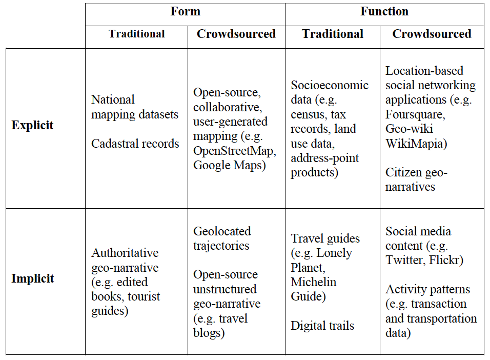
A typology of implicit and explicit form and function content

In addition, we also discuss in the paper how these new sources of data, which are often at finer resolutions than more authoritative data are allowing us to to customize the we we aggregate the data  at various geographical levels as shown below. Such aggregations can range from building footprints and addresses to street blocks (e.g. for density analysis), or street networks (e.g. for accessibility analysis). For large-scale urban analysis we can revert to the use of zonal geographies or grid systems.  
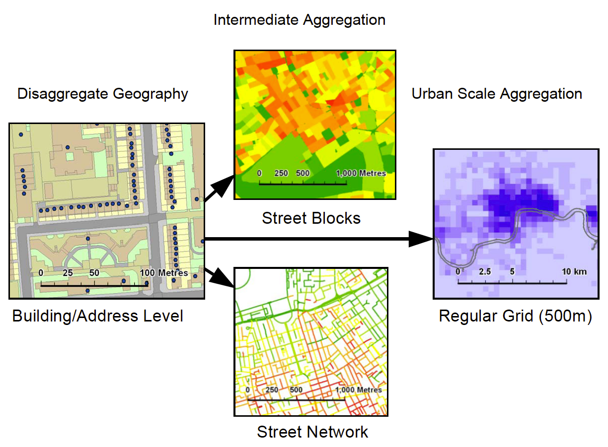
Aggregation methods for varied scales of built environment analysis

In the application section of the paper we highlight how we can extract implicit form and function from crowdsourced data. The image below for example, shows how we can take information from Twitter, and differentiate different neighborhoods over space and time.

Neighborhood map and topic modeling results showing the mixture of social functions in each area.
Finally in the paper, we outline an emerging research agenda related to the “persistent urban morphology concept” as shown below. Specifically how crowdsourcing is changing how we collect, analyze and model urban morphology. Moreover, how this new paradigm provides a new lens for studying the conceptualization of how cities operate, at much finer temporal, spatial, and social scales than we had been able to study so far.

The persistent urban morphology concept.

We hope you enjoy the paper.

Full Reference:  

Crooks, A.T., Pfoser, D., Jenkins, A., Croitoru, A., Stefanidis, A., Smith, D. A., Karagiorgou, S., Efentakis, A. and Lamprianidis, G. (2015), Crowdsourcing Urban Form and Function, International Journal of Geographical Information Science. DOI: 10.1080/13658816.2014.977905 (pdf)


Continue reading »

International Encyclopedia of Geography – Quality Assurance of VGI

The Association of American Geographers is coordinating an effort to create an International Encyclopedia of Geography. Plans started in 2010, with an aim to see the 15 volumes project published in 2015 or 2016. Interestingly, this shows that publishers and scholars are still seeing the value in creating subject-specific encyclopedias. On the other hand, the weird […]

Continue reading »

OpenStreetMap studies (and why VGI not equal OSM)

As far as I can tell, Nelson et al. 2006 ‘Towards development of a high quality public domain global roads database‘ and Taylor & Caquard 2006 Cybercartography: Maps and Mapping in the Information Era are the first peer review papers that mention OpenStreetMap. Since then, OpenStreetMap received plenty of academic attention. More ‘conservative’ search engines such as ScienceDirect […]

Continue reading »

Happy 10th Birthday, OpenStreetMap!

Today, OpenStreetMap celebrates 10 years of operation as counted from the date of registration. I’ve heard about the project when it was in early stages, mostly because I knew Steve Coast when I was studying for my Ph.D. at UCL.  As a result, I was also able to secured the first ever research grant that focused […]

Continue reading »

Crowdsourced Geographic Information in Government

Today marks the publication of the report ‘crowdsourced geographic information in government‘. The report is the result of a collaboration that started in the autumn of last year, when the World Bank Global Facility for Disaster Reduction and Recovery(GFDRR)  requested to carry out a study of the way crowdsourced geographic information is used by governments. The […]

Continue reading »

Crowdsourcing, Citizen Science and INSPIRE

The INSPIRE 2014 conference marks the middle of the implementation process of  the INSPIRE directive (Infrastructure for Spatial Information in the European Community). The directive is aimed at establishing a pan-European Spatial Data Infrastructure (SDI), and that mean lots of blueprints, pipes, machine rooms and protocols for enabling the sharing of geographic information. In GIS jargon,  blueprints translate to […]

Continue reading »

Assertions on crowdsourced geographic information & citizen science #3

Following the two previous assertions, namely that: ‘you can be supported by a huge crowd for a very short time, or by few for a long time, but you can’t have a huge crowd all of the time (unless data collection is passive)’ (original post here) And ‘All information sources are heterogeneous, but some are more […]

Continue reading »

Assertions on crowdsourced geographic information & citizen science #2

Following the last post, which focused on an assertion about crowdsourced geographic information and citizen science I continue with another observation. As was noted in the previous post, these can be treated as ‘laws’ as they seem to emerge as common patterns from multiple projects in different areas of activity – from citizen science to crowdsourced […]

Continue reading »

Assertions on crowdsourced geographic information & citizen science #1

Looking across the range of crowdsourced geographic information activities, some regular patterns are emerging and it might be useful to start notice them as a way to think about what is possible or not possible to do in this area. Since I don’t like the concept of ‘laws’ – as in Tobler’s first law of […]

Continue reading »
1 2 3