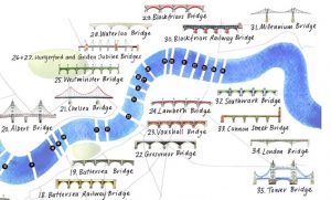
13 Bridges Challenge
The 13 Bridges Challenge, organised by SSAFA (the Armed Forces charity) is taking place on Saturday 24 June (this Saturday) and participants will be walking
Continue reading »The latest outputs from researchers, alumni and friends at the UCL Centre for Advanced Spatial Analysis (CASA).

The 13 Bridges Challenge, organised by SSAFA (the Armed Forces charity) is taking place on Saturday 24 June (this Saturday) and participants will be walking
Continue reading »London has a lot more rivers than just the River Thames and River Lea – but many of the rest are either very small and easily overlooked, or buried underground (culverted), typically by industrious Victorians looking to clean up channels that bec…
Continue reading »The Little Globe Company is Loraine Rutt, a London-based cartographer and artist who specialises in maps created from clay, perhaps most famously crafting and hand-painting miniature porcelain globes in painstakingly precise detail. Her output is not just globe-based though, as this piece, showing London’s relief (hills and valleys) as well as its river network, both […]
Continue reading »
The River Thames is London’s defining geographical feature and its inclusion is almost mandatory on any map attempting to cover the whole of the capital. Bridges are most Londoners’ visible contact with the river, with over 30 spanning the river in London, including elevated crossing by the so-called “Underground”. As such, illustrated maps of the […]
Continue reading »As London swelters a heatwave, people in search of a cooling waterside stroll might notice that London doesn’t apparently have many rivers. There is of course the mighty River Thames, and a few others here and there visible. But there are many more that you don’t just come across – they are just hidden underground. […]
Continue reading »
Londoners will be very familiar with the crowded London Underground services and their famous diagrammatic Tube Map, but might be less familiar with another public transport network – boats on the River Thames. Yes, you can commute to work by catamaran – as long as you live and work close to the river. London’s river […]
Continue reading »
These attractive hand-drawn maps have been produced for a pocket guide “London’s Canals & Rivers” published by the Canal & River Trust by illustrator and cartographer Bek Cruddace. They show the navigable waterways around London, including the Thames and Lea Rivers and the Regent’s and Grand Union canals. The maps are designed for walkers and […]
Continue reading »
Every year, for the last few years, Mapping London editors Oliver and James have been invited to create and submit an artwork for 10×10 London, a charity art auction organised by Article 25, the architectural development charity (originally called Architects for Aid). Being neither artists or architects, it is very flattering that we have been […]
Continue reading »
The London Thames Path is a brand new book by author/il […]
Continue reading »
This is a new work by Stephen Walter, in his characteri […]
Continue reading »Canalology is a short “festival of contemporary a […]
Continue reading »Travelling around London is a little harder today. With […]
Continue reading »
The London Thames is a new poster – a small extra […]
Continue reading »