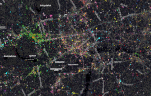
A Celestial Map
Ever thought the ribbon of the River Thames, weaving it […]
Continue reading »The latest outputs from researchers, alumni and friends at the UCL Centre for Advanced Spatial Analysis (CASA).

Ever thought the ribbon of the River Thames, weaving it […]
Continue reading »
Edit: See new Central London image below! One recent bit of research I have been working on has been looking at the application of community detection algorithms to traffic flow in London. The idea is that within the traffic system exist a number …
Read more →
I’ve been using 37Signals’ Basecamp now for over 5 years. I’m involved in many projects with people from multiple departments and organisations. In the first large project that I run in 2007 – Mapping Change for Sustainable Communities – Basecamp was recommended to us by Nick Black (just before he co-founded CloudMade), so we’ve started […]![]()
Spatial interaction lies at the basis of much of our science but it has been hard, if not impossible to develop an equivalent theory of social interactions. Social interactions are hard to pin down, hard to observe and explain but … Continue reading →
Continue reading »
I’ve made some minor alterations to the CSV API for CityDashboard. The main changes are in the metadata rows (the top two) rather than the subsequent rows. Specifically, the top metadata row has now split out the description, source and … Continue reading →
Continue reading »
In an attempt to find out a little bit about how development projects have been distributed between countries and types of project (health, education etc.) I have created a kind of trawler for Google information. You give the trawler three … Continue reading →
Continue reading »Last week, I attended a round table discussion about Social Enterprise and Higher Education Institutions at the department of Business, Innovation and Skills (BIS). The meeting was part of a larger event on social enterprise that was organised by Social Enterprise UK and UnLtd to mark Social Enterprise day. The discussion explored different aspects in […]![]()

We’ve featured at least three maps since the last […]
Continue reading »Check out Luc D’Acci’s Blog. He has some very interesting projects on mega cities and the internal structure of cities which blends lots of ideas from economics and complexity theory with spatial structures and patterns. Some papers are downloadable
Continue reading »
I’ve been looking into whether Google’s “search result count” facility can help direct the focus of my research a little bit, by recording the result count for a series of search strings relating to different countries, in different years, and … Continue reading →
Continue reading »One last lecture before I seek landfall back In Blighty after a long trip. Today at Portugal’s oldest University Coimbra (founded 1290). Click to see pdf. This is a reworking of our lecture on real time data analysis of London’s … Continue reading →
Continue reading »As part of the ESRC Festival of Social Science, CASA and Leeds University held a three day event at Leeds City museum called “Smart Cities: Bridging the Physical and Digital”. This took place on the 8th, 9th and 10th of November. The museum’s central arena venue for the exhibition was a fantastic choice because of …
Read more →
12 years ago we held a meeting in CASA on Cellular Automata Models. David O’Sullivan and Paul Torrens, both PhD students at the time – in fact David had finished and it was just before he went to Penn State … Continue reading →
Continue reading »Here is a pretty picture of envelopes which are overlaid each with their maximum range (including the observed curve) … to allow multiple variables to be looked at simultaneously even when the range of each curve is very different! For example in year 2011 health, social grade, and transport to work are well below their 1% …
Read more →

Let me start this post with a couple of disclaimers: 1) This post is of no interest to anyone other than myself and possibly a few of my colleagues at UCL’s Centre for Advanced Spatial Analysis. It’s here as a … Continue reading →
Continue reading »Tweet17th-18th December 2012 To be held at the RGS-IBG Headquarters, London Background to the conference 20 years ago, Champion and Fielding’s (1992) two volume edited collection on migration patterns and processes was published. This provided a landmark intervention within migration studies and wider human geography, demonstrating how different types of migration in GB were undergoing […]
Continue reading »Check out our paper in Scientific Reports published on the 6th November. Click to Open Access, so no fear of breaking copyright by reading it ! What a surprise. We or rather a grant paid for it. What we argue … Continue reading →
Continue reading »This interesting meeting is being held in Oporto, Portugal and involves a reassessment of progress and problems in this field of simulation. I am giving the keynote at 2-30pm November 8th -19th and the pdf of my power point can … Continue reading →
Continue reading »
image source: obey magazine
3D Paris is an interactive application designed for IPad and following Recce, it aims in bringing the 3D city closer to the user. The viewer can wander in the streets of Paris of 1829, learn about the evolution of the city, or enjoy an aerial view of the city from the top floor of the Eiffel tower.
In this application the city itself becomes the object of interest, creating a bridge between the broader public and urban history. Virtual reality and the interactive approaches of gaming are being applied on the actual form of the city and that makes me wonder of how long till we see interactive city planning.
In any case, watching something like this makes me anticipate for an application narrating the history of Athens, the Parthenon and the Ancient Agora. I am looking forward to chatting with the ancient philosophers instead of kinect’s (now cancelled) “Milo“…
Experience 3D Paris in your browser at:
http://paris.3ds.com/#Patrimoine
for more images:
Read more »
Tweet Closing date :30/11/2012 Reference :HUM-01939 Faculty / Organisational unit :Humanities School / Directorate :School of Social Sciences Division :Social Statistics Salary : £32,901 to £55,908 Employment type :Permanent Hours per week :Full-time Location :Oxford Road We wish to recruit three Lecturers or Senior Lecturers in Social Statistics / Quantitative Social Science. These posts are tenable […]
Continue reading »Data engineers examined more than 3 million tweets to create this sprawling linguistic cartography.See it on Scoop.it, via Spatial Analysis
Continue reading »Data engineers examined more than 3 million tweets to create this sprawling linguistic cartography.See it on Scoop.it, via Spatial Analysis
Continue reading »Alternative Tube Maps: The Electric Tube | LondonistLondonistThe latest artistic re-imagining of the malleable London Underground map comes courtesy of Oliver O'Brien (@oobr), of UCL's Centre for Advanced Spatial Analysis (CASA). Responding to …
Continue reading »Following on from my previous post about controlling the Hex Bug spiders from a computer, I’ve added a computer vision system using a cheap web cam to allow them to be tracked. The web cam that I’m using is a Logitech C270, but mainly because it was the cheapest one in the shop (£10). I’ve …
Read more →
Alternative Tube Maps: The Electric Tube LondonistThe latest artistic re-imagining of the malleable London Underground map comes courtesy of Oliver O’Brien (@oobr), of UCL’s Centre for Advanced Spatial …
Continue reading »
In six weeks time, London will have a second orbital railway. The Circle Line has been running for just over 100 years, and on 9 December will be joined by the latest addition to Transport for London (TfL)’s Overground network … Continue reading →
Continue reading »A couple of days ago I posted how you can go about installing Routino on OSX; and now I have just finished writing a quick post over on my Rpubs blog about how you go about using it from within R. I also wanted to know a bit more about how R and Twitter play […]
Continue reading »
Recently I reviewed a book for JASSS entitled “Modeling and Simulating Urban Processes” edited by Andreas Koch and Peter Mandl. The full review can be found here.Modelling and Simulating Urban Processes brings together six papers ranging from spatial-e…
Continue reading »
Recently I reviewed a book for JASSS entitled “Modeling and Simulating Urban Processes” edited by Andreas Koch and Peter Mandl. The full review can be found here.Modelling and Simulating Urban Processes brings together six papers ranging from spatial-e…
Continue reading »
We have just had a paper published in Journal of Artificial Societies and Social Simulation the entitled “Slumulation: An Agent-Based Modeling Approach to Slum Formations”. This paper adds to the small but growing body of agent-based models explo…
Continue reading »
We have just had a paper published in Journal of Artificial Societies and Social Simulation the entitled “Slumulation: An Agent-Based Modeling Approach to Slum Formations”. This paper adds to the small but growing body of agent-based models explo…
Continue reading »
This is intriguing, a new 3D package to map and explore data – Datascape, by Daden Ltd, known perviously for their work in Second Life, provides an immersive environment in which users can explore and interact with data from almost any source. David Burden, Daden’s Managing Director said “Datascape is ground-breaking and we’re…
Continue reading »The Jugular Project, led by Shama Rahman, is one of those brave beasts that attempts to meld science and art – or as they have it, “the head and the heart” – with talks from physicists, biologists and gerentologists, among … Continue reading →![]()
Heat map reveals Olympic tweetsLegalbrief (subscription)The map, inspired by one by self-named 'map geek' Eric Fischer, was compiled for the social network site by James Cheshire, a lecturer at University College London's Centre for Advance…
Continue reading »A couple of days ago I posted how you can go about installing Routino on OSX; and now I have just finished writing a quick post over on my Rpubs blog about how you go about using it from within R. I also wanted to know a bit more about how R and Twitte…
Continue reading »For the Smart Cities exhibition in Leeds in a couple of weeks, we’ve been building a physical representation of an agent based simulation. Hex Bug Spiders are relatively cheap hexapod robots that are controlled via an infra-red transmitter which has an A or B code so that you can control two simultaneously. The way it walks …
Read more →

Rentonomy, who describe themselves as, for now, “ […]
Continue reading »