Esri User Conference 2016 – plenary day

The main Esri User conference starts with a plenary day, where all the participants (16,000 of them) join together for a set of presentation from 8:30 to 3:30 (with some breaks, of course). Below you’ll find some notes that I took during the day: The theme of the keynote was GIS – Enabling a Smarter … Continue reading Esri User Conference 2016 – plenary day

Continue reading »

Esri Education Conference 2016 – day 1

I’ve been working with Geographic Information Systems (GIS) since 1988. During the first 2 years, I wasn’t even aware that what we were doing was GIS – it was a mapping/inventory system that run on second generation PC (80286 processors) and was used to map facilities. Once I’ve discovered that this was a GIS, the … Continue reading Esri Education Conference 2016 – day 1

Continue reading »

Esri Education User Conference talk: Citizen Science & Geographical Technologies: creativity, learning, and engagement

The slides below are from my keynote talk at the Esri Education User Conference 2016. The conference focused on creativity and its relevant to education and the utilisation of GIS (especially Esri software) at different levels of education. My talk explored the area of citizen science and extreme citizen science and the way geographical technologies … Continue reading Esri Education User Conference talk: Citizen Science & Geographical Technologies: creativity, learning, and engagement

Continue reading »

A review of volunteered geographic information quality assessment methods

One of the joys of academic life is the opportunity to participate in summer schools – you get a group of researchers, from PhD students to experienced professors, to a nice place in the Italian countryside, and for a week the group focuses on a topic – discussing, demonstrating and trying it out. The Vespucci … Continue reading A review of volunteered geographic information quality assessment methods

Continue reading »

A Semester with Urban Analytics

This past semester I gave a new class at GMU entitled “Urban Analytics”. In a nutshell the class was about introducing students to a broad interdisciplinary field that focuses on the use of data to study cities. More specifcally the emphasis of the cla…

Continue reading »

New PhD Opportunity: Human Computer Interaction and Spatial Data Quality for Online Civic Engagement

We have a new scholarship opening at the Extreme Citizen Science group for a PhD student who will research in Human Computer Interaction and Spatial Data Quality for Online Civic Engagement. The studentship is linked and contextualised by the European Union H2020 funded project, WeGovNow! . This project will focus on the use of digital technologies for effectively … Continue reading New PhD Opportunity: Human Computer Interaction and Spatial Data Quality for Online Civic Engagement

Continue reading »

Living Maps Review launched today

Living Maps review is a new online journal about maps, map making and thinking of mapping (I’m on the editorial board of the journal). As the launch email describes: “map making as a democratic medium for visual artists, writers, social  researchers and community activists. The journal has its roots in the highly successful series of … Continue reading Living Maps Review launched today

Continue reading »

Extreme Citizen Science in Esri ArcNews

The winter edition of Esri ArcNews (which according to Mike Gould of Esri, is printed in as many copies as Forbes) includes an article on the activities of the Extreme Citizen Science group in supporting indigenous groups in mapping. The article highlights the Geographical Information Systems (GIS) aspects of the work, and mentioning many members of … Continue reading Extreme Citizen Science in Esri ArcNews

Continue reading »

“Space, the Final Frontier”: How Good are Agent-Based Models at Simulating Individuals and Space in Cities?

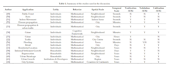
Recently, Alison Heppenstall, Nick Malleson  and myself have just had a paper accepted in Systems entitled: “Space, the Final Frontier”: How Good are Agent-Based Models at Simulating Individuals and Space in Cities?” In the paper we critically examine how well agent-based models have  simulated a variety of urban processes. We discus what considerations are needed when choosing the appropriate level of spatial analysis and time frame to model urban phenomena and what role Big Data can play in agent-based modeling. Below you can read the abstract of the paper and see a number of example applications discussed.

Abstract: Cities are complex systems, comprising of many interacting parts. How we simulate and understand causality in urban systems is continually evolving. Over the last decade the agent-based modeling (ABM) paradigm has provided a new lens for understanding the effects of interactions of individuals and how through such interactions macro structures emerge, both in the social and physical environment of cities. However, such a paradigm has been hindered due to computational power and a lack of large fine scale datasets. Within the last few years we have witnessed a massive increase in computational processing power and storage, combined with the onset of Big Data. Today geographers find themselves in a data rich era. We now have access to a variety of data sources (e.g., social media, mobile phone data, etc.) that tells us how, and when, individuals are using urban spaces. These data raise several questions: can we effectively use them to understand and model cities as complex entities? How well have ABM approaches lent themselves to simulating the dynamics of urban processes? What has been, or will be, the influence of Big Data on increasing our ability to understand and simulate cities? What is the appropriate level of spatial analysis and time frame to model urban phenomena? Within this paper we discuss these questions using several examples of ABM applied to urban geography to begin a dialogue about the utility of ABM for urban modeling. The arguments that the paper raises are applicable across the wider research environment where researchers are considering using this approach.

Keywords: cities; agent-based modeling; big data; crime; retail; space; simulation

Figure 1. (A) System structure; (B) System hierarchy; and (C) Related subsystems/processes (adapted from Batty, 2013).

Reference cited:

Batty, M. (2013).  The New Science of Cities; MIT Press: Cambridge, MA, USA.

Full reference to the open access paper:

Heppenstall, A., Malleson, N. and Crooks A.T. (2016). “Space, the Final Frontier”: How Good are Agent-based Models at Simulating Individuals and Space in Cities?, Systems, 4(1), 9; doi: 10.3390/systems4010009 (pdf)


Continue reading »

“Space, the Final Frontier”: How Good are Agent-Based Models at Simulating Individuals and Space in Cities?

Recently, Alison Heppenstall, Nick Malleson  and myself have just had a paper accepted in Systems entitled: “Space, the Final Frontier”: How Good are Agent-Based Models at Simulating Individuals and Space in Cities?” In the paper we critically examine how well agent-based models have  simulated a variety of urban processes. We discus what considerations are needed when choosing the appropriate level of spatial analysis and time frame to model urban phenomena and what role Big Data can play in agent-based modeling. Below you can read the abstract of the paper and see a number of example applications discussed.

Abstract: Cities are complex systems, comprising of many interacting parts. How we simulate and understand causality in urban systems is continually evolving. Over the last decade the agent-based modeling (ABM) paradigm has provided a new lens for understanding the effects of interactions of individuals and how through such interactions macro structures emerge, both in the social and physical environment of cities. However, such a paradigm has been hindered due to computational power and a lack of large fine scale datasets. Within the last few years we have witnessed a massive increase in computational processing power and storage, combined with the onset of Big Data. Today geographers find themselves in a data rich era. We now have access to a variety of data sources (e.g., social media, mobile phone data, etc.) that tells us how, and when, individuals are using urban spaces. These data raise several questions: can we effectively use them to understand and model cities as complex entities? How well have ABM approaches lent themselves to simulating the dynamics of urban processes? What has been, or will be, the influence of Big Data on increasing our ability to understand and simulate cities? What is the appropriate level of spatial analysis and time frame to model urban phenomena? Within this paper we discuss these questions using several examples of ABM applied to urban geography to begin a dialogue about the utility of ABM for urban modeling. The arguments that the paper raises are applicable across the wider research environment where researchers are considering using this approach.

Keywords: cities; agent-based modeling; big data; crime; retail; space; simulation

Figure 1. (A) System structure; (B) System hierarchy; and (C) Related subsystems/processes (adapted from Batty, 2013).

Reference cited:

Batty, M. (2013).  The New Science of Cities; MIT Press: Cambridge, MA, USA.

Full reference to the open access paper:

Heppenstall, A., Malleson, N. and Crooks A.T. (2016). “Space, the Final Frontier”: How Good are Agent-based Models at Simulating Individuals and Space in Cities?, Systems, 4(1), 9; doi: 10.3390/systems4010009 (pdf)


Continue reading »

UCL Institute for Global Prosperity Talk: Extreme Citizen Science – Current Developments

The slides below are from a talk that I gave today at UCL Institute for Global Prosperity The abstract for the talk is: With a growing emphasis on civil society-led change in diverse disciplines, from International Development to Town Planning, there is an increasing demand to understand how institutions might work with the public effectively … Continue reading UCL Institute for Global Prosperity Talk: Extreme Citizen Science – Current Developments

Continue reading »

Citizen Science Data & Service Infrastructure

Following the ECSA meeting, the Data & tools working group workshop was dedicated to progressing the agenda on data & infrastructure. Jaume Piera (chair, Data and Tools working group of ECSA) covered the area of citizen science data – moving from ideas, to particular solutions, to global proposals – from separate platforms (iNaturalist, iSpot, GBIF, … Continue reading Citizen Science Data & Service Infrastructure

Continue reading »

Environmental information: between scarcity/abundance and emotions/rationality

The Eye on Earth Summit, which was held in Abu Dhabi last week, allowed me to immerse myself in the topics that I’ve been researching for a long time: geographic information, public access to environmental information, participation, citizen science, and the role of all these in policy making. My notes (day 1 morning, day 1 afternoon, … Continue reading Environmental information: between scarcity/abundance and emotions/rationality

Continue reading »

Being philosophical about crowdsourced geographic information

Originally posted on Geo: Geography and Environment:
By Renée Sieber (McGill University, Canada) and Muki Haklay (University College London, UK) Our recent paper, The epistemology(s) of volunteered geographic information: a critique, started from a discussion we had about changes within the geographic information science (GIScience) research communities over the past two decades. We’ve both been working in the…

Continue reading »

Eye on Earth (Day 3 – Afternoon) Remote sensing, conservation monitoring and closing remarks

The afternoon of the last day of Eye on Earth included two plenary sessions, and a discussion (for the morning, see this post). The first plenary focused on Remote sensing and location enabling applications: Taner Kodanaz (digitalglobe) technology that looking out to the sky now allow us to look at the Earth from 400 miles. Digital … Continue reading Eye on Earth (Day 3 – Afternoon) Remote sensing, conservation monitoring and closing remarks

Continue reading »

Eye on Earth (Day 2 – Afternoon) – Cost of knowledge, citizen science & visualisation

The first afternoon session was dedicated to Understanding the Costs of Knowledge – Cost of Data Generation and Maintenance (my second day morning post is here) The session was moderated by Thomas Brooks (IUCN) – over the last couple of days we heard about innovation in mobilisation of environmental and socio-economic data. All these innovations have … Continue reading Eye on Earth (Day 2 – Afternoon) – Cost of knowledge, citizen science & visualisation

Continue reading »

Eye on Earth (Day 2 – Morning) – moving to data supply

Eye on Earth (Day 2 – Morning) – moving to data supply The second day of Eye on Earth moved from data demand to supply . You can find my posts from day one, with the morning and the afternoon sessions. I have only partial notes on the plenary Data Revolution-data supply side, although I’ve posted separately the slides from … Continue reading Eye on Earth (Day 2 – Morning) – moving to data supply

Continue reading »
1 3 4 5 6 7 11