London’s Hidden Rivers
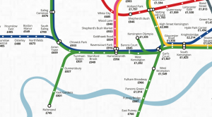
As London swelters a heatwave, people in search of a cooling waterside stroll might notice that London doesn’t apparently have many rivers. There is of course the mighty River Thames, and a few others here and there visible. But there are many more that you don’t just come across – they are just hidden underground. […]
Continue reading »